- Landmarks of the Nebraska Territory
-
Landmarks of the Nebraska Territory were important to settlers on the Oregon, California and Mormon trails. While the majority of the landmarks were close to the Platte River, others were spread across the state.[1]
Contents
The trails
Landmarks in the Nebraska Territory were often related to their proximity to the several trails that crossed the area. The Oregon and California Trails entered the Territory from the Kansas Territory Kansas at Gage County. They continue east/northeasterly across present-day Nebraska. The Mormon Trail entered the Nebraska Territory at Cutler's Park, across the Missouri River from Kanesville, Iowa. It continued easterly along the Elkhorn and Platte Rivers.
Landmarks
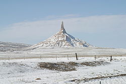 Chimney Rock, 2002
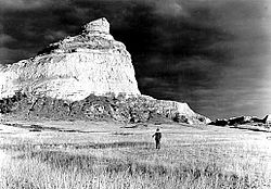 Scotts Bluff, 1938. Photo: George A. Grant
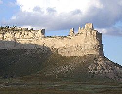 Saddle Rock in Scotts Bluff National Monument
Landmarks of the Nebraska Territory (East-to-west order) Name Nearest town Details Audubon Spring Creek Prairie Denton Rock Creek Station Endicott A Pony Express Station and now a State Historical Park. Setting of an 1861 gunfight between David McCanles and Wild Bill Hickok. Oak Grove Station Oak A Pony Express station is marked by a monument commemorating an 1864 Indian battle called the Little Blue Raid. Simonton-Smith wagon train attack site Hastings First fatal action of the Indian War of 1864. Spring Ranch Pauline A stagecoach stop, trading post and village. Susan Hail Grave Kenesaw Died 2 June 1852, probably of cholera. Many emigrants, including William Woodhams, described her grave. Her grief stricken husband returned to St. Joseph for a tombstone and moved it by wheelbarrow back to this location. Fort Kearny (Fort Childs) Kearney An open fort made of sod and adobe, and located south of the Platte River. Midway Station Gothenburg Built in 1855 as a trading post before being used as an Overland stage station and Pony Express station. Mark Twain referenced it in his 1872 novel, Roughing It, as did Charles Dawson and Mattes & Henderson. Cottonwood Springs Maxwell The only good water along the trails in either direction. Fort McPherson Maxwell Important during the Indian Wars. Among the dead at the Fort McPherson National Cemetery is Spotted Horse. Also a monument to the 1854 Grattan Massacre. O'Fallon's Bluff Sutherland On the south bank of the South Platte River, location of a stage station and military post. Beauvais Trading Post (Starr Ranch) Brule An 1859 trading post was established by Geminien P. Beauvais, and the famous pre-1859 Upper Crossing or Old California Crossing. California Crossing Brule A South Platte River crossing. Windlass Hill and Ash Hollow State Historical Park Big Springs- Lewellen-area Rachel Pattison Grave at Ash Hollow Cemetery Lewellen John Hollman Grave Oshkosh Courthouse and Jail Rocks Bridgeport Courthouse Rock is a sandstone outcropping south of the Oregon Trail. A smaller feature to the east is called the Jail Rock. Chimney Rock National Historic Site Bayard A clay and sandstone column resembling a tall factory chimney that is over 300 feet (91 m) today. Rebecca Winter's Grave site Scottsbluff Rebecca Winters of the Mormon pioneers died enroute to Salt Lake City. Scotts Bluff Gering A bluff over the North Platte River, now within Scotts Bluff National Monument. Mitchell Pass Gering A gap in the Wildcat Hills used by travelers on the Emigrant Trail after 1851 after improvement by the United States Army Corps of Engineers, now within Scotts Bluff National Monument. Pierre D. Papin Grave Gering Pierre was a well known trapper who died at nearby Fort John in May 1853. Robidoux Trading Post Gering Small log trading post was established by Joseph E. Robidoux in late 1848. See also
References
- ^ "Nebraska Trail Sites", Nebraska Chapter of Oregon-California Trails Association. Retrieved 9/7/07.
Categories:- Landmarks in Nebraska
- Pre-state history of Nebraska
- Visitor attractions in Nebraska
- Nebraska Territory


Wikimedia Foundation. 2010.