- Bad Mergentheim
-
Bad Mergentheim 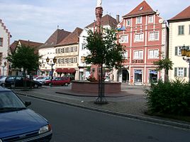


 Bad MergentheimLocation of the town of Bad Mergentheim within Main-Tauber-Kreis district
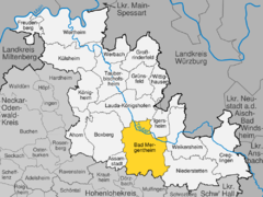
Coordinates 49°30′0″N 9°46′0″E / 49.5°N 9.766667°ECoordinates: 49°30′0″N 9°46′0″E / 49.5°N 9.766667°E Administration Country Germany State Baden-Württemberg Admin. region Stuttgart District Main-Tauber-Kreis Town subdivisions Kernstadt and 13 Stadtteile Lord Mayor Udo Glatthaar (CDU) Basic statistics Area 129.97 km2 (50.18 sq mi) Elevation 206 m (676 ft) Population 22,394 (31 December 2010)[1] - Density 172 /km2 (446 /sq mi) Other information Time zone CET/CEST (UTC+1/+2) Licence plate TBB Postal code 97980 Area code 07931 Website www.bad-mergentheim.de Bad Mergentheim (Mergentheim until 1926) is a town in the Main-Tauber district in the German state of Baden-Württemberg.
Contents
History
Mergentheim is mentioned in chronicles as early as 1058, as the residence of the family of the counts of Hohenlohe, who early in the 13th century assigned the greater part of their estates in and around Mergentheim to the Teutonic order. In 1340 Mergentheim got Town privileges. It rapidly increased in fame, and became the most important of the eleven commanderies of that society. On the secularization of the Teutonic Order in Prussia in 1525, Mergentheim became the residence of the grand master, and remained so until the final dissolution of the order in 1809 by Napoleon.
Bad Mergentheim's fortunes were reversed in 1826, when a shepherd by the name of Franz Gehring discovered rich mineral springs in the surrounding area, during the time when spas were expanding in Germany at a rapid pace. The water turned out to be the strongest sodium-sulfate water in all of Europe, especially effective for the treatment of digestive disorders.
In the 1970s several neighbouring villages were incorporated during the "Gemeindereform".
Year Population 1660 1,064 1855 2,917 1900 4,372 1933 6,191 1945 9,300 1950 10,184 1961 11,608 1975 19,895 1990 21,567 2005 22,486 Villages
(inhabitants)
Althausen (600), Apfelbach (350), Dainbach (370), Edelfingen (1.400), Hachtel (360), Herbsthausen (200), Löffelstelzen (1,000), Markelsheim (2,000), Neunkirchen (1,000), Rengershausen (480), Rot (260), Stuppach (680), Wachbach (1,300)Main sights
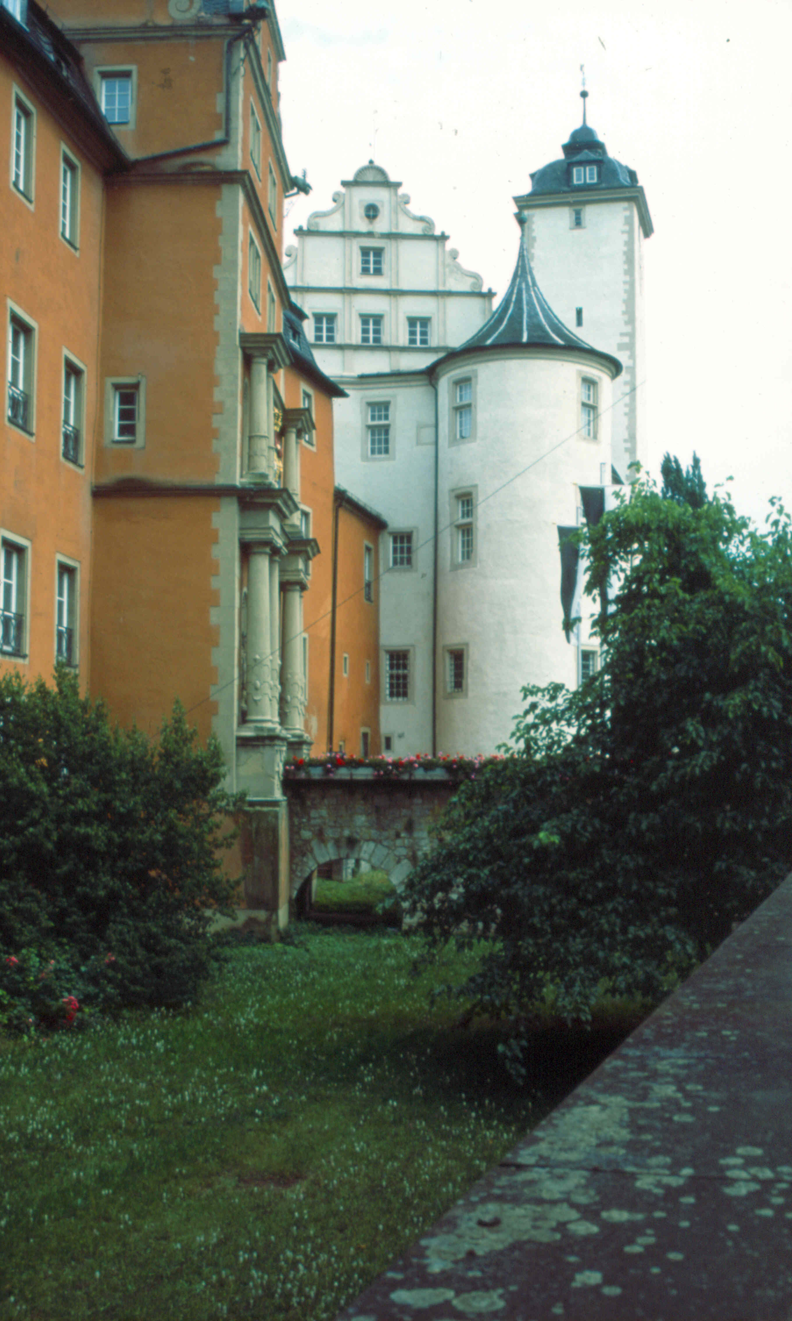
 Deutschordenschloss
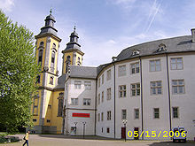 Deutschordenschloss - Interior including Deutschordensmuseum and Schlosskirche Towers.
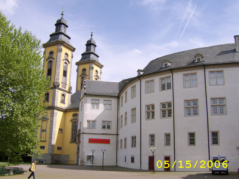
The most interesting sight in Bad Mergentheim is the Deutschordenschloss, the medieval castle where the Teutonic Knights once had their home base. It is a complex of buildings built over a period of eight hundred years. The first buildings of the castle were probably erected as early as the 12th century. The castle was expanded in the late 16th century under Grand Master Walter von Cronberg. Over the course of time a representative Renaissance complex was built by connecting the individual buildings in the inner palace courtyard to a closed ring of buildings. In 1574, the main architect, Blasius Berwart, also constructed the spiral staircase between the west and north wing still famous today. Today the castle houses the Deutschordensmuseum (Museum of the Teutonic Order).
The castle complex is dominated by the Schlosskirche (Castle Church), built in 1730 in Baroque style. Its Rococo interior features elaborate ceiling frescos by the court painter Nikolaus Gottfried Stuber, depicting The Defense of Faith, the Glorification of the Cross in Heaven and on Earth and the Emperor Constantine's Vision of the Cross. Almost 200 years ago the Schlosskirche became a Protestant church.
Modern facilities
- Löffelstelzen Transmitter
Twin towns — sister cities
Bad Mergentheim is twinned with:
Notable residents and natives
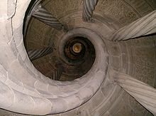 Spiral staircase in the Deutschordensmuseum.
- Heinrich von Hohenlohe, buried in the church in Mergentheim
- Ottmar Mergenthaler, (1854–1899), inventor of the Linotype[2]
- Felix Fechenbach, (1894–1933) German journalist, poet and political activist, who was murdered by the Nazis
- Barbara Stamm, German politician and vice-chairwoman of the CSU
- Fritz Kuhn, German politician and former co-chairman of the German Green Party
- Martin Lanig, German footballer
- Eduard Mörike, German poet, lived in Bad Mergentheim from 1844-1851.
- Ludwig van Beethoven, was viola player in the court's musical establishment of the Hochmeister (Grand Master) of the Teutonic Knights Maximilian Franz of Austria in 1791.
- Edvard Hjelt, Finnish chemist and politician, died July 2, 1921 in Bad Mergentheim
Notes
- ^ "Bevölkerung und Erwerbstätigkeit" (in German). Statistisches Landesamt Baden-Württemberg. 31 December 2009. http://www.statistik-bw.de/Veroeffentl/Statistische_Berichte/3126_10001.pdf.
- ^ Who Was Who in America, Historical Volume, 1607-1896. Chicago: Marquis Who's Who. 1963.
References
 This article incorporates text from a publication now in the public domain: Chisholm, Hugh, ed (1911). Encyclopædia Britannica (11th ed.). Cambridge University Press.
See also
 Franconian Circle (1500–1806) of the
  Holy Roman Empire
Ecclesiastical 
Secular Ansbach · Bayreuth · Henneberg (Römhild, Schleusingen) · Hohenlohe-Waldenburg · Löwenstein-Wertheim · SchwarzenbergCounts / Lords Cities Ahorn | Assamstadt | Bad Mergentheim | Boxberg | Creglingen | Freudenberg am Main | Großrinderfeld | Grünsfeld | Igersheim | Königheim | Külsheim | Lauda-Königshofen | Niederstetten | Tauberbischofsheim | Weikersheim | Werbach | Wertheim am Main | Wittighausen Categories:
- Towns in Baden-Württemberg
- Castles of the Teutonic Knights
- Spa towns in Germany
- Main-Tauber district
- Franconian Circle


Wikimedia Foundation. 2010.