- Pennsylvania Route 616
-
PA Route 616
Route information Maintained by PennDOT Length: 14.9 mi[1] (24 km) Existed: 1930 – present Major junctions South end:  PA 851 in Railroad
 PA 216 in Glen Rock
 PA 214 in Seven Valleys
North end:  US 30 in West Manchester Township.
Location Counties: York Highway system Roads in Pennsylvania
Interstate • US • State • Legislative←  PA 615
PA 618  →
→Pennsylvania Route 616 (PA 616) is an 15-mile (24 km) long state highway located in York county in Pennsylvania. The southern terminus is at PA 851 in Railroad. The northern terminus is at US 30 in West Manchester Township.
Route description
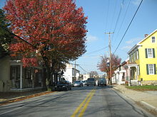 PA 616 in New Salem
PA 616 begins at an intersection with PA 851 in Railroad, heading northwest on two-lane undivided North Main Street. The road runs through hilly forested areas and passes under the York County Heritage Rail Trail before entering Shrewsbury Township and becoming Pleasant Valley Road. The route continues to the east of the Old Mill Creek and the rail trail as it passes through more wooded areas with a few homes. PA 616 passes a few farms before it turns west and crosses the Old Mill Creek and passes under the trail, making a curve north to run along the west bank of the creek. The road runs through more forests with small areas of homes and fields, continuing into Glen Rock. At this point, the route becomes Baltimore Street and heads northwest past homes before intersecting PA 216. Here, PA 616 turns northwest to form a concurrency with PA 216 on Main Street, passing businesses in the center of town as it crosses the creek and the York County Heritage Rail Trail and an inactive railroad line. The road heads into more wooded areas again as it crosses back into Shrewsbury Township.[1][2]
PA 216 splits from PA 516 by heading northeast on Glen Rock Road, and PA 616 makes a turn west onto Seven Valleys Road, crossing the South Branch Codorus Creek and the trail/railroad line before turning northwest into Codorus Township. The route runs through more hilly forests immediately to the west of the rail trail and the creek. Farther to the northwest, PA 616 winds through a mix of farmland and woodland with a few homes, eventually reaching the community of Seltzville. From here, the road continues northwest through wooded areas of residences and reaches Hanover Junction, crossing into North Codorus Township. The route curves north past more farms and woods, intersecting the western terminus of PA 214 near Seven Valleys. Here, PA 616 turns northwest to continue on Seven Valleys Road, heading away from the creek and rail trail. The road passes through more hilly forests before entering a mix of farmland, woodland, and residences. The route heads into New Salem, where it becomes Main Street and passes homes and businesses. Upon leaving New Salem, PA 616 becomes Trinity Road and runs through woodland before heading into farmland and crossing the Codorus Creek into West Manchester Township. In this area, the route crosses a York Railway line and continues through more agricultural surroundings with a few homes. PA 616 reaches its northern terminus at an intersection with US 30.[1][2]
Major intersections
The entire route is in York County.
Location Mile Destinations Notes Railroad 0.0 PA 851 (South Main Street/East Main Street)Glen Rock 3.2 PA 216 west (Manchester Street)Southern end of concurrency 3.9 PA 216 east (Glen Rock Road)Northern end of concurrency Seven Valleys 9.1 PA 214 east (Main Street)Western terminus of PA 214 West Manchester Township 14.9 US 30 (Market Street)1.000 mi = 1.609 km; 1.000 km = 0.621 mi References
- ^ a b c Google, Inc. Google Maps – overview of Pennsylvania Route 616 (Map). Cartography by Google, Inc. http://maps.google.com/maps?f=d&source=s_d&saddr=PA+616+and+PA+851&daddr=US+30+and+PA+616&hl=en&geocode=FRuxXgIdiKRt-ykJmg2gRGTIiTGP9nH5LBwgZA%3BFdVTYQId5wBs-ylDDtRxPIvIiTG4VDm1eGE_6Q&mra=ls&sll=39.794293,-76.835632&sspn=0.237412,0.676346&ie=UTF8&ll=39.847031,-76.753235&spn=0.23723,0.676346&t=h&z=11. Retrieved February 25, 2011.
- ^ a b PennDOT (2011). York County, Pennsylvania Highway Map (Map). ftp://ftp.dot.state.pa.us/public/pdf/BPR_pdf_files/Maps/GHS/Roadnames/york_GHSN.PDF. Retrieved February 22, 2011.
Categories:- State highways in Pennsylvania


Wikimedia Foundation. 2010.