Amungula Parish, Murray

Amungula Parish, Murray

Infobox Australian cadastral
name = Amungula Parish
state = New South Wales


imagesize = 250px
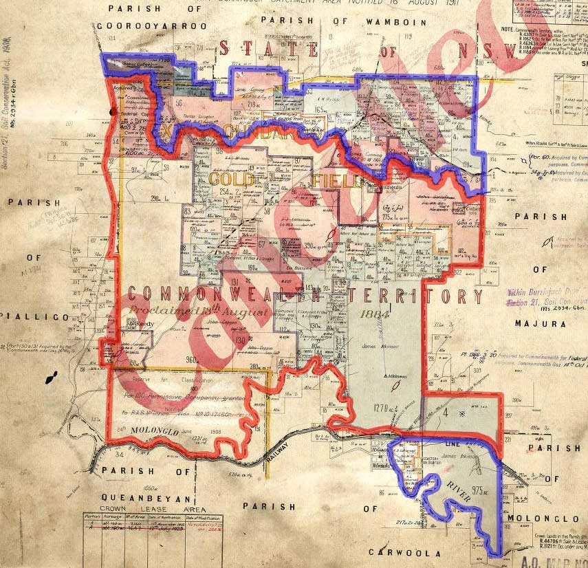
caption = Early 20th Century cadastral map with highlights: legend|#130eff|The two sections of Amungula parish since 1909 legend|#e5151a|Formerly part of the parish; transferred to the Commonwealth for the ACT in 1909
lga = Palerang Council
county = Murray
land district = Queanbeyan
division = Eastern
hundred =
est =
near-nw = Goorooyarroo
near-n = Wamboin
near-ne = Majura
near-e = Majura
near-se = Molonglo
near-s = Carwoola
near-sw = Queanbeyan
near-w = Pialligo
note = The 'cadastral units' around box refers to the original nineteenth century parish, not the current two portions of the parish.

Amungula Parish, Murray County is a parish of Murray County, New South Wales, a cadastral unit for use on land titles. It is located in two non-contiguous sections, divided by the Australian Capital Territory, as most of the parish was transferred to the ACT in 1909. The northern section, the larger of the two, is located just to the south of Wamboin around coord|35|15|50|S|149|17|29|E|type:city; the southern, a section of land between the Goulburn-Queanbeyan railway and the Molonglo River around coord|35|20|48|S|149|19|49|E|type:city. Before 1909, the Molonglo River was the southern boundary of the parish. The Kings Highway passes through a small part of the southern remaining portion. It was formerly located in Yarrowlumla Shire, but is now located in Palerang Council.

External links

* [http://www.nla.gov.au/cdview/nla.map-gmod83-sd&mode=moreinfo Map showing proposed Federal Capital Territory and tenures of land within same, Charles Robt. Scrivener, 22nd May, 1909]
* [http://www.gnb.nsw.gov.au/name_search/extract?id=JPKqwpUl Geographic names board of New South Wales]


Wikimedia Foundation. 2010.

Игры ⚽ Поможем написать курсовую

Look at other dictionaries:

  • Majura Parish, Murray — Infobox Australian cadastral name = Majura Parish state = New South Wales imagesize = 250px caption = 1924 cadastral map with highlights: legend|#130eff|Boundary of Majura parish since 1909 legend|#e5151a|The eastern tip of the ACT, which was… …   Wikipedia

  • Goorooyarroo Parish, Murray — Infobox Australian cadastral name = Goorooyarroo Parish state = New South Wales imagesize = 250px caption = 1932 cadastral map with highlights: legend|#130eff|Boundary of Goorooyarroo parish since 1909 legend|#e5151a|Formerly part of the parish;… …   Wikipedia

  • Queanbeyan Parish, Murray — Infobox Australian cadastral name = Queanbeyan Parish state = New South Wales imagesize = 250px caption = legend|#130eff|The Parish of Queanbeyan since 1909 legend|#e5151a|Formerly part of the parish; transferred to the Commonwealth for the ACT… …   Wikipedia

  • Carwoola Parish, Murray — Infobox Australian cadastral name = Carwoola Parish state = New South Wales imagesize = caption = lga = Palerang Council and Queanbeyan land district = Queanbeyan county = Murray hundred = est = near nw = Amungula near n = Molonglo near ne =… …   Wikipedia

  • Pialligo Parish, Murray — Infobox Australian cadastral name = Pialligo Parish state = New South Wales imagesize = caption = lga = Palerang Council county = Murray hundred = est = near nw = Goorooyarroo near n = Goorooyarroo near ne = Wamboin near e = Amungula near se =… …   Wikipedia

  • Wamboin Parish, Murray — Infobox Australian cadastral name = Wamboin Parish state = New South Wales imagesize = caption = lga = Palerang Council county = Murray land district = Queanbeyan division = Eastern est = near nw = Goorooyarroo near n = Bywong near ne = Lake… …   Wikipedia

  • Murray County, New South Wales — Map of all coordinates from Google Map of all coordinates from Bing Export all coordinates as KML …   Wikipedia

  • Majura Parish — New South Wales 1924 cadastral map with highlights:   Boundary of Majura paris …   Wikipedia

Share the article and excerpts

Direct link
Do a right-click on the link above
and select “Copy Link”