Land District of Queanbeyan
- Land District of Queanbeyan
Infobox Australian cadastral
name = Land District of Queanbeyan
state = New South Wales
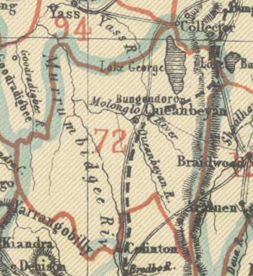
caption = Map of the district in 1907
county = Murray, Cowley, Buccleuch
division = Eastern
lga = Yarrowlumla Shire (former)
board = Cooma
region =
est =
area =
near-nw = Yass
near-n = Yass
near-ne = Goulburn
near-e = Braidwood
near-se = Braidwood
near-s = Cooma
near-sw = Tumut
near-w = Tumut
The Land District of Queanbeyan was one of the around 100 land districts of New South Wales which were introduced with the Crown Lands Act of 1884. It was based around the town of Queanbeyan, and included the area from near Lake George in the north, to Colinton in the south, and west to the Goodradigbee River and beyond it. In 1909, a large part of the district was transferred to the Commonwealth government to become the Australian Capital Territory.
The district was located in the Eastern Division, and included land in the counties of Murray and Cowley, and a small part of Buccleuch. In 1890 the district was part of the Cooma Land Board [ [http://nla.gov.au/nla.map-rm894-1 Map of New South Wales shewing all divisions for the purposes of the Crown Lands Acts, 1890] . MAP RM 894, National Library of Australia] . By 1907 the district was administered by the Goulburn Land Board [ [http://nla.gov.au/nla.map-rm2795 Map of New South Wales showing all divisions for the purposes of the Crown Lands acts. 1907] . MAP RM 2795. National Library of Australia] . Cadastral maps made in the area have the name of the land district written on them. [ [http://nla.gov.au/anbd.bib-an000040994878 Parish of Gibralter, County of Cowley, Land District of Queanbeyan] , Cadastral map showing parish boundaries and land holdings. ] [ [http://www.nla.gov.au/cdview/nla.map-f46&mode=moreinfo Plan of the town of Queanbeyan] , parish of Queanbeyan, County of Murray, land district of Queanbeyan N.S.W. 1887]
References
Wikimedia Foundation.
2010.
Look at other dictionaries:
Queanbeyan Parish, Murray — Infobox Australian cadastral name = Queanbeyan Parish state = New South Wales imagesize = 250px caption = legend|#130eff|The Parish of Queanbeyan since 1909 legend|#e5151a|Formerly part of the parish; transferred to the Commonwealth for the ACT… … Wikipedia
Queanbeyan — /ˈkwinbiən/ (say kweenbeeuhn) noun a city in NSW, just east of Canberra; agriculture; building industry. Queanbeyan is in territory traditionally inhabited by the Ngunnawal people. The area was explored by Charles Throsby Smith and his party in… …
Murray County, New South Wales — Map of all coordinates from Google Map of all coordinates from Bing Export all coordinates as KML … Wikipedia
Histoire du Territoire de la capitale australienne — La ville de Canberra. L histoire du Territoire de la capitale australienne (ACT), une division administrative de l Australie a commencé après la création de la Fédération de l Australie en 1901, quand une loi crée le site de Canberra, la capitale … Wikipédia en Français
Lands administrative divisions of New South Wales — The 141 counties of New South Wales, with the original Nineteen shown in pink … Wikipedia
Carwoola Parish, Murray — Infobox Australian cadastral name = Carwoola Parish state = New South Wales imagesize = caption = lga = Palerang Council and Queanbeyan land district = Queanbeyan county = Murray hundred = est = near nw = Amungula near n = Molonglo near ne =… … Wikipedia
Tuggeranong Parish, Murray — Infobox Australian cadastral name = Tuggeranong Parish state = New South Wales imagesize = 220px caption = 1904 cadastral map with highlights: legend|#130eff|Boundary of Tuggeranong parish since 1909 legend|#e5151a|Formerly part of the parish;… … Wikipedia
Narrabundah Parish, Murray — Infobox Australian cadastral type = former parish name = Narrabundah Parish state = Australian Capital Territory imagesize = 180px caption = Map of the parish from 1904 lga = Yarrowlumla Shire (former) county = Murray land district = Queanbeyan… … Wikipedia
Narrabundah Parish — Australian Capital Territory Map of the parish from 1904 County: Murray Land District … Wikipedia
Amungula Parish, Murray — Infobox Australian cadastral name = Amungula Parish state = New South Wales imagesize = 250px caption = Early 20th Century cadastral map with highlights: legend|#130eff|The two sections of Amungula parish since 1909 legend|#e5151a|Formerly part… … Wikipedia