Queanbeyan Parish, Murray
- Queanbeyan Parish, Murray
Infobox Australian cadastral
name = Queanbeyan Parish
state = New South Wales
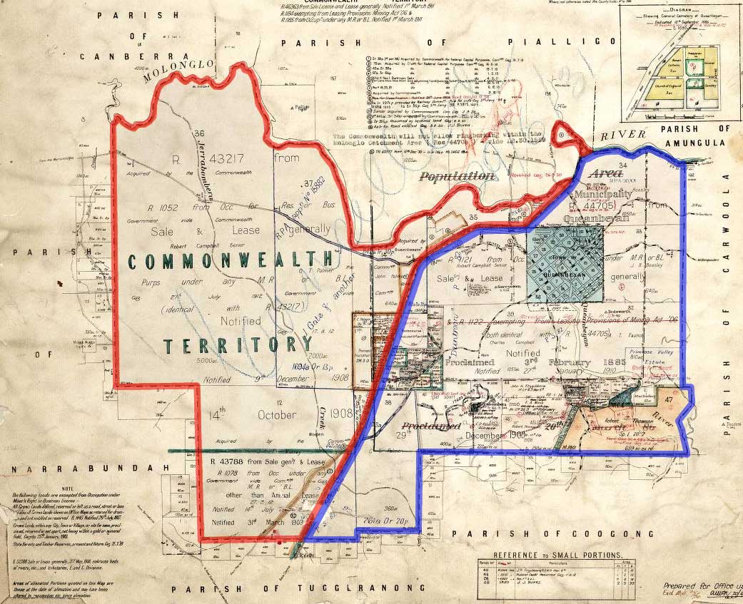
imagesize = 250px
caption = legend|#130eff|The Parish of Queanbeyan since 1909 legend|#e5151a|Formerly part of the parish; transferred to the Commonwealth for the ACT in 1909
lga = Palerang Council
county = Murray
land district = Queanbeyan
hundred =
est =
near-nw = Canberra
near-n = Pialligo
near-ne = Amungula
near-e = Carwoola
near-se = Googong
near-s = Googong
near-sw = Tuggeranong
near-w = NarrabundahQueanbeyan Parish, Murray County is a parish of Murray County, New South Wales, a cadastral unit for use on land titles. It covers the city of Queanbeyan. It was originally bounded by the Molonglo River to the north, but is now bounded by the NSW-ACT border in the north and west. Parts of the western area of the parish were transferred to the Australian Capital Territory in 1909, including what are now the Canberra suburbs of Fyshwick, Narrabundah, Kingston, Oaks Estate, Harman and part of Hume.
References
* [http://nla.gov.au/anbd.bib-an000040821018 Draft assessment of crown land at Queanbeyan, Parish of Queanbeyan]
* [http://www.nla.gov.au/cdview/nla.map-gmod83-sd&mode=moreinfo Map showing proposed Federal Capital Territory and tenures of land within same, Charles Robt. Scrivener, 22nd May, 1909]
* [http://www.gnb.nsw.gov.au/name_search/extract?id=ujjtjzsyKW Geographic Names Board of New South Wales]
Wikimedia Foundation.
2010.
Look at other dictionaries:
Carwoola Parish, Murray — Infobox Australian cadastral name = Carwoola Parish state = New South Wales imagesize = caption = lga = Palerang Council and Queanbeyan land district = Queanbeyan county = Murray hundred = est = near nw = Amungula near n = Molonglo near ne =… … Wikipedia
Tuggeranong Parish, Murray — Infobox Australian cadastral name = Tuggeranong Parish state = New South Wales imagesize = 220px caption = 1904 cadastral map with highlights: legend|#130eff|Boundary of Tuggeranong parish since 1909 legend|#e5151a|Formerly part of the parish;… … Wikipedia
Narrabundah Parish, Murray — Infobox Australian cadastral type = former parish name = Narrabundah Parish state = Australian Capital Territory imagesize = 180px caption = Map of the parish from 1904 lga = Yarrowlumla Shire (former) county = Murray land district = Queanbeyan… … Wikipedia
Amungula Parish, Murray — Infobox Australian cadastral name = Amungula Parish state = New South Wales imagesize = 250px caption = Early 20th Century cadastral map with highlights: legend|#130eff|The two sections of Amungula parish since 1909 legend|#e5151a|Formerly part… … Wikipedia
Canberra Parish, Murray — Infobox Australian cadastral type = former parish name = Canberra Parish state = Australian Capital Territory imagesize = 180px caption = 1888 map of the parish lga = Yarrowlumla Shire (former) county = Murray land district = Queanbeyan division … Wikipedia
Majura Parish, Murray — Infobox Australian cadastral name = Majura Parish state = New South Wales imagesize = 250px caption = 1924 cadastral map with highlights: legend|#130eff|Boundary of Majura parish since 1909 legend|#e5151a|The eastern tip of the ACT, which was… … Wikipedia
Keewong Parish, Murray — Infobox Australian cadastral name = Keewong Parish state = New South Wales imagesize = caption = lga = Palerang Council county = Murray land district = Queanbeyan hundred = est = near nw = Gigerline near n = Burra near ne = Urialla near e =… … Wikipedia
Goorooyarroo Parish, Murray — Infobox Australian cadastral name = Goorooyarroo Parish state = New South Wales imagesize = 250px caption = 1932 cadastral map with highlights: legend|#130eff|Boundary of Goorooyarroo parish since 1909 legend|#e5151a|Formerly part of the parish;… … Wikipedia
Gigerline Parish, Murray — Infobox Australian cadastral type = former parish name = Gigerline Parish state = Australian Capital Territory imagesize = caption = lga = Yarrowlumla Shire (former) county = Murray land district = Queanbeyan hundred = est = near nw = Congwarra… … Wikipedia
Pialligo Parish, Murray — Infobox Australian cadastral name = Pialligo Parish state = New South Wales imagesize = caption = lga = Palerang Council county = Murray hundred = est = near nw = Goorooyarroo near n = Goorooyarroo near ne = Wamboin near e = Amungula near se =… … Wikipedia