- Nafpaktia
-
Nafpaktia
ΝαυπακτίαLocation 
 Nafpaktia
Coordinates 38°23′N 21°49′E / 38.383°N 21.817°ECoordinates: 38°23′N 21°49′E / 38.383°N 21.817°E Location within the region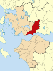
Government Country: Greece Region: West Greece Regional unit: Aetolia-Acarnania Population statistics (as of 2001) Municipality - Population: 29,842 - Area: 870.4 km2 (336 sq mi) - Density: 34 /km2 (89 /sq mi) Other Time zone: EET/EEST (UTC+2/3) Nafpaktia (Greek: Ναυπακτία) is a municipality in the Aetolia-Acarnania peripheral unit, West Greece Periphery, Greece. The seat of the municipality is the town Naupactus.[1]
Contents
Municipality
The municipality Nafpaktia was formed at the 2011 local government reform by the merger of the following 6 former municipalities, that became municipal units:[1]
Geography
Nafpaktia is one of the most popular mountainous areas in Greece. Visitors observe the scenery, as well as participate in outdoor activities such as mountainous trekking, biking, horseback-riding, and archery. The approximately 60 villages are famous for their scenery. The villages are built at altitudes of 700–1,000 m (2,300–3,300 ft) and are located from 30–90 km (19–56 mi) away of Nafpaktos, surrounded by rich vegetation and natural springs.
Elatou is approximately one hour away from Nafpaktos and is built in a pine forest. This small, picturesque settlement is built amphitheatrically, while it only has a few permanent residents. Another popular village is Ano Chora. It used to be called Megali Lobotina, while it has a population of 30. It has narrow cobblestone paths and traditional houses, while there are many guesthouses, which are quite popular in the winter months. Katafygio is also one of the historical villages in mountainous Nafpaktia. The village is built at an altitude of 650 m (2,130 ft), and abstains 33 km (21 mi) from Nafpaktos. Katafygio in the old days was named Amorani.
External links
- Nafpaktia and Nafpaktos
- Nafpaktia
- Katafygion Nafpaktias
- Katafigio Nafpaktias(Mountainous Nafpaktia)
- Paleopirgos (Mountainous Nafpaktia)
References
- ^ a b Kallikratis law Greece Ministry of Interior (Greek)
Administrative division of the West Greece Region 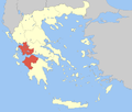 Regional unit of Elis
Municipal unit of Apodotia Ano Chora · Ampelakiotissa · Anavryti · Aspria · Elatovrysi · Elatou · Grammeni Oxya · Grigori · Kalloni · Katafygio · Kato Chora · Kentriki · Kokkinochori · Kryoneria · Kydonea · Lefka · Limnitsa · Mandrini · Podos · TerpsitheaMunicipal unit of Chalkeia Ano Vasiliki · Gavrolimni · Galatas · Kalavrouza · Perithori · Trikorfo · VasilikiMunicipal unit of Naupactus Municipal unit of Platanos Achladokastro · Agios Dimitrios · Arachova · Chomori · Dendrochori · Kastanea · Klepa · Livadaki · Neochori · Perdikovrysi · Perista · PlatanosMunicipal unit of Pyllini Anthofyto · Dorvitsia · Eleftheriani · Famila · Gavros · Milea · Palaiopyrgos · Pokista · Simos · Stranoma · StyliaCategories:- Populated places in Aetolia-Acarnania
- Municipalities of West Greece
- Mountains of Greece
- Greece geography stubs


Wikimedia Foundation. 2010.