- Gert Town, New Orleans
Geobox Neighborhood
name = Gert Town
native_name =
other_name =
other_name1 =
category = New Orleans Neighborhood

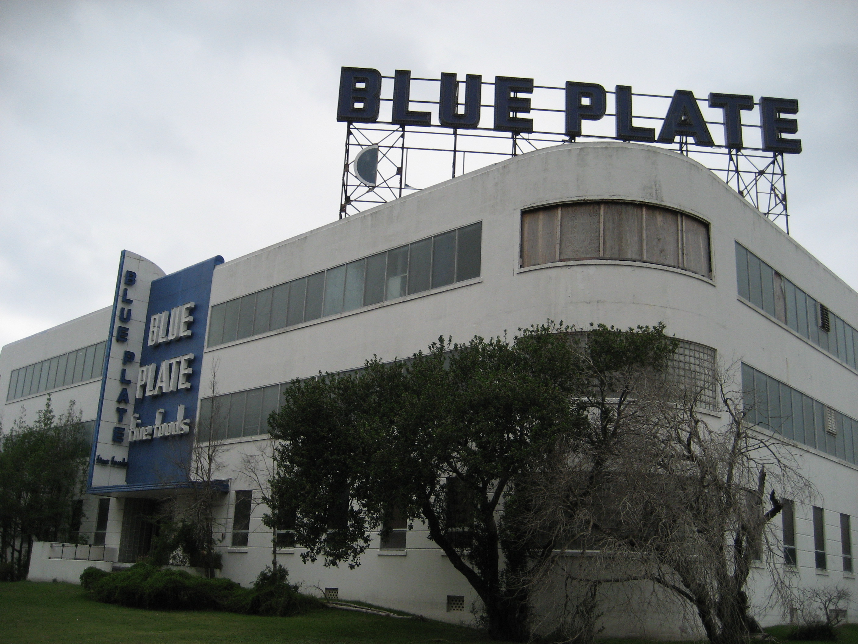
image_caption = Blue Plate Mayonnaise factory
flag_size =
symbol =
symbol_size =
etymology_type =
etymology =
nickname =
motto =
country = United States
state = Louisiana
region_type = City
region = New Orleans
district_type = Planning District
district = District 4, Mid-City District
area_imperial = 0.73
area_land_imperial = 0.73
area_water_imperial = 0.00
area_water_percentage = auto
area_percentage_round = 2
area_round = 1
location =
lat_d = 29
lat_m = 57
lat_s = 37
lat_NS = N
long_d = 90
long_m = 06
long_s = 19
long_EW = W
elevation_imperial = 0
elevation_round = 1
population_as_of = 2000
population = 4748
population_density_imperial = auto
established_type =
established =
mayor =
timezone = CST
utc_offset = -6
timezone_DST = CDT
utc_offset_DST = -5
postal_code =
postal_code_type = ZIP Codes
area_code = 504
area_code_type =
code2_type =
code2 =
free_type =
free =
free1_type =
free1 =
map_size =
map_caption =
map_locator =
map_locator_x =
map_locator_y =
website =Gert Town (sometimes referred to as Zion City) is a neighborhood of the city of New Orleans. A subdistrict of the Mid-City District Area, its boundaries as defined by the City Planning Commission are: Palmetto Street, South Carrollton Avenue and the
Pontchartrain Expressway to the north, South Broad Street to the east, MLK Boulevard, Washington Avenue, Eve Street, Jefferson Davis Parkway,Earhart Boulevard , Broadway and Colapissa Streets, South Carrollton Avenue and Fig Street to the south and Cambronne, Forshey, Joliet, and Edinburgh Streets to the west.Geography
Gert Town is located at coor dms|29|57|37|N|90|06|19|W|city GR|1 and has an elevation of convert|0|ft|1GR|3. According to the
United States Census Bureau , the district has a total area of convert|0.73|mi2|1. convert|0.73|mi2|1 of which is land and convert|0.00|mi2|1 (0.0%) of which is water.Cityscape and landmarks
A prominent figure in the community is
Xavier University of Louisiana , located in the northern corner of the neighborhood.A busy commercial strip is along the section of Carrollton Avenue running through the neighborhood. In the 1990s, a portion of the fascade of the large Walker-Roemer Dairy building was preserved and incorporated into a new post office.
Other small businesses are scatted along Washington Avenue; until
Hurricane Katrina one was the well known Ultrasonic Studios.In the mid 20th century a manufacturing district developed around Jefferson Davis Boulevard, including the local
Coca-Cola bottling plant and theArt Deco landmark "Blue Plate"mayonnaise factory. Manufacturing around here declined in the late 20th century, and was largely ended in the Katrina flooding disaster. The businesses along Davis Parkway that have succeeded in rebuilding include the studios of television stationWVUE .Other neighborhood landmarks include the Gert Town Pool, a public
swimming pool in a domed structure run by the New Orleans Recreation Department.Adjacent Neighborhoods
* Dixon (north)
* Mid-City (north)
*Calliope Projects (east)
* Central City (south)
* Broadmoor (south)
* Fontainebleau (south)
* Leonidas (west)
* Hollygrove (west)Boundaries
The City Planning Commission defines the boundaries of Gert Town as these streets: Palmetto Street, South Carrollton Avenue, the Pontchartrain Expressway, South Broad Street, MLK Boulevard, Washington Avenue, Eve Street, Jefferson Davis Parkway, Earhart Boulevard, Broadway Street, Colapissa Street, South Carrollton Avenue, Fig Street, Cambronne Street, Forshey Street, Joliet Street and Edinburgh Street. [cite web|url=http://gnocdc.org/orleans/4/62/index.html|title=Gert Town Neighborhood|author=Greater New Orleans Community Data Center|accessdate=2008-06-21]
Demographics
As of the
census GR|2 of 2000, there were 4,748 people, 1,541 households, and 789 families residing in the neighborhood. Thepopulation density was 7,558 /mi² (2,859 /km²).History
The most commonly accepted explantion for the neigborhood's name is that it is a corruption of "Gehrke's Town", Gehrke's being a
general store formerly located at Carrollton & Colapissa streets which around 1900 was a local gathering place and had the area's only telephone.In 1900 the "Tulane St. Charles Belt" streetcar line opened including the Gert Town section of Carrollton Avenue in its route, spuring development. Starting in 1902, Lincoln Park and adjacent Johnson Park were popular with
African American s in the era ofracial segregation ; the parks featured a skating rink, balloon ascent exhibitions, and dancing to the music of such notables asBuddy Bolden andBunk Johnson .Gert Town's odd street pattern is the result of earlier land development that reflected the bends in the
Mississippi River . With a lower elevation than other areas, the area was once part of the swampy "Back of Town," and major streets stopped before entering the area. After some marginal residential development in the late nineteenth and early twentieth century, older Uptown streets that were perpendicular to the river tended to meet in Gert Town and Mid-City. Many of the narrow side streets in Gert Town remained unpaved longer than those in other neighborhoods.This fairly small area was further cut off by the
New Basin Canal , which was located where Interstate 10 is today. Because of its location, in some ways Gert Town seems to have been overlooked throughout its history; poverty and crime have been recurrent problems, particularly in the later twentieth century.Like the majority of the city, Gert Town flooded from the levee failures in the aftermath of Hurricane Katrina in 2005. Except for a few sections along major throughfares like Carrollton Avenue and Jefferson Davis Parkway, recovery remains slow three years later.
Gert Town is now one of several strategic zones designated by the city for redevelopment and community reinforcement.
ee also
*
New Orleans neighborhoods References
*Campanella, Richard. Time and Place in New Orleans: Past Geographies in the Present Day. Gretna, Louisiana: Pelican Publishing Company, 2002. ISBN 1-56554-991-0
External links
* [http://www.gnocdc.org/orleans/4/62/snapshot.html Neighborhood profile at GNOCDC]
* [http://www.cityofno.com/Portals/Portal49/portal.aspx?portal=49&tabid=1 Neighborhood 1, city agency that oversees community redevelopment]
Wikimedia Foundation. 2010.
