- Ugashik-Peulik
-
Ugashik-Peulik 
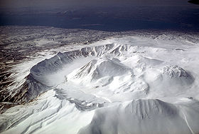
Aerial view, looking southwest, of Ugashik caldera adjacent to Peulik volcano.Elevation 4,836 ft (1,474 m) Location Location Lake and Peninsula Borough, Alaska, USA Range Aleutian Range Coordinates 57°45′04″N 156°22′05″W / 57.751°N 156.368°W Topo map USGS Geology Type Stratovolcano Volcanic arc/belt Aleutian Arc Last eruption 1814 Ugashik-Peulik is a stratovolcano in the U.S. state of Alaska. It is located to the south of Becharof Lake in Lake and Peninsula Borough on the Alaska Peninsula. It is part of the Aleutian Range. Its last eruption was in 1814.
Sources
- "Ugashik-Peulik". Global Volcanism Program, Smithsonian Institution. http://www.volcano.si.edu/world/volcano.cfm?vnum=1102-13-.
- Volcanoes of the Alaska Peninsula and Aleutian Islands-Selected Photographs
- Alaska Volcano Observatory
Categories:- Landforms of Lake and Peninsula Borough, Alaska
- Stratovolcanoes
- Mountains of Alaska
- Volcanoes of Alaska
- Aleutian Range
- Southwest Alaska geography stubs
Wikimedia Foundation. 2010.

