- Nanto, Toyama
-
Nanto
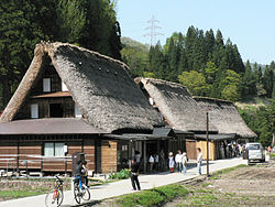
南砺市— City — Traditional thatching roof style homes in Ainokura, Gokayama
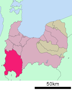
FlagLocation of Nanto in Toyama Coordinates: 36°35′06″N 136°55′21″E / 36.585°N 136.9225°ECoordinates: 36°35′06″N 136°55′21″E / 36.585°N 136.9225°E Country Japan Region Chūbu (Hokuriku) Prefecture Toyama Government - Mayor Mikio Tanaka (since November 2008) Area - Total 668.86 km2 (258.2 sq mi) Population (May 31, 2011) - Total 55,315 - Density 82.70/km2 (214.2/sq mi) Time zone Japan Standard Time (UTC+9) Phone number 0763-23-2003 Address 4880 Naeshima, Nanto-shi, Toyama-ken
939-1596Website City of Nanto Nanto (南砺市 Nanto-shi) is a city located in Toyama Prefecture, Japan.
Contents
History
As of 2000, 8 municipalities that merged into the city had an estimated total population of 60,182 with an average population density of 89.98 persons per km². The total area is 668.86 km². As of May 31, 2011, the population of Nanto is 55,315 persons, with 17,386 households.
The city was founded on November 1, 2004 with the merger of eight towns and villages, all are from Higashitonami District, except Fukumitsu.
The city takes its name from its relative location to the neighboring city Tonami, the south—"nan" (南) in Japanese—and the first syllable of the neighboring city's name—"to" (砺).
Geography
Geographically, the city is very diverse, containing numerous rivers, valleys, mountains and lakes, as well as abundant level ground for rice paddies.
See also
External links
 Media related to Nanto, Toyama at Wikimedia Commons
- Official website (Japanese)
- Official website (English)
 Toyama Prefecture
Cities 
Nakaniikawa District Shimoniikawa District Categories:- Cities in Toyama Prefecture
- Toyama geography stubs
Wikimedia Foundation. 2010.


