- Orford Ness
-
Orford Ness 

Type National Nature Reserve, Site of Special Scientific Interest, internationally important site for nature conservation, former military test site Location 52°04′53″N 01°33′31″E / 52.08139°N 1.55861°E near Orford, Suffolk Operator Ministry of Defence (United Kingdom), Atomic Weapons Research Establishment, National Trust for Places of Historic Interest or Natural Beauty Status Inactive In use 1913 – early 1983 Orford Ness is a cuspate foreland shingle spit on the Suffolk coast in Great Britain, linked to the mainland at Aldeburgh and stretching along the coast to Orford and down to North Wier Point, opposite Shingle Street. It is divided from the mainland by the River Alde, and was formed by longshore drift along the coast. The material of the spit comes from places further north, such as Dunwich. Near the middle point of its length, at the foreland point or 'Ness', lies the Orfordness lighthouse.[1] Note that, in the name of the lighthouse (and the radio transmitting station - see below), ‘Orfordness’ is written as one word.
Orford Ness is an internationally important site for nature conservation. It contains a significant portion of the European reserve of vegetated shingle habitat,[2] which is internationally scarce, highly fragile and very easily damaged. Together with Havergate Island the site is a designated National Nature Reserve[3] and forms part of: the Alde-Ore Estuary Site of Special Scientific Interest (SSSI);[4] the Alde, Ore & Butley Estuaries[5] and the Orfordness-Shingle Street[6] Special Area of Conservation (SAC); the Alde-Ore Estuary Special Protection Area (SPA);[7] the Alde-Ore Estuary Ramsar Site site;[8] the Suffolk Coasts and Heaths Area of Outstanding Natural Beauty (AONB);[9] and the Suffolk Heritage Coast.[10] It is also listed as of national importance in the Geological Conservation Review (GC),[11] as a grade 1 site in the Nature Conservation Review.[12] (NCR) and qualifies for the DEFRA Environmentally Sensitive Area (ESA) scheme.[13]
Contents
History
The peninsula was formerly administered by the Ministry of Defence, which conducted secret military tests during both world wars and the Cold War. The Atomic Weapons Research Establishment had a base on the site, used for environmental testing. When a laboratory test is conducted to determine the functional performance of a component or system under conditions that simulate the real environment in which the component or system is expected to operate. Many of the buildings from this time remain clearly visible from the quay at Orford, including the distinctive "pagodas". Whilst it is maintained that no fissile material was tested on the site, the very high explosive initiator charge was present and the buildings were designed to absorb any accidental explosion, allowing gases and other material to vent and dissipate in a directed or contained manner. In the event of a larger accident, the roofs were designed to collapse onto the building, sealing it with a lid of concrete.
The Orfordness transmitting station was built on the peninsula in the late 1970s and early 1980s using the site and building of an experimental military over-the-horizon radar known as Cobra Mist, which had closed in 1973. This powerful mediumwave radio station - originally owned and run by the Foreign Office, then the BBC and, after privatization in the 1990s, a series of private companies - is best known for transmitting BBC World Service in English around the clock to continental Europe on 648 kHz from September 1982 until March 2011. Following the ending of these broadcasts, and with no other major clients for the station, its future is uncertain.
In the 1930s Orford Ness was the site of the first purpose built experiments on the defence system that would later be known as radar. Having proved the technology on Orford Ness Robert Watson-Watt and his team moved to nearby Bawdsey Manor and developed the Chain Home radar system in time for its vital role in the Battle of Britain.
Orford Ness is now owned by the National Trust and is open to the public under the name "Orford Ness National Nature Reserve", though access is strictly controlled to protect the fragile habitats and due to a residual danger to the public from the site's former use by the military. Access is therefore only available by the National Trust ferry from Orford Quay on designated open days.[14]
Rachel Woodward writes:[15][16]
“ It is a place of strange contrasts. For the National Trust, its 'elemental nature' contrasts with the 'inherent dangers' of this place, a 'hostile and potentially dangerous site'. Military structures – the Bomb Ballistics Building, the Black Beacon, the 'pagodas' used for explosive design – have been converted into viewing spots. This is not a celebratory site, however; there is ambivalence and doubt here, with regard to what is being physically and ideologically conserved. ” Owing to its military history, its stark appearance and the fact that it was closed to the public for many decades, several apocryphal stories have circulated about Orford Ness. The best-known is the suggestion that Nazi troops attempted to invade England and actually disembarked at the tip of the peninsula near Shingle Street, before being repelled with a wall of fire. Official sources denied any such attempted invasion took place, an assertion apparently confirmed by classified documents released in 1993. More recently, the flashes of the lighthouse were implicated in the Rendlesham Forest UFO sightings of late December 1980.
-
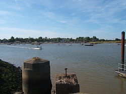
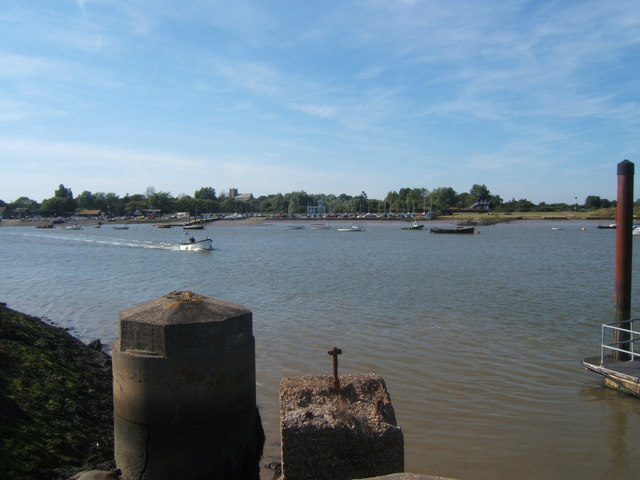
View from the Orford Ness dock towards Orford Quay.
-

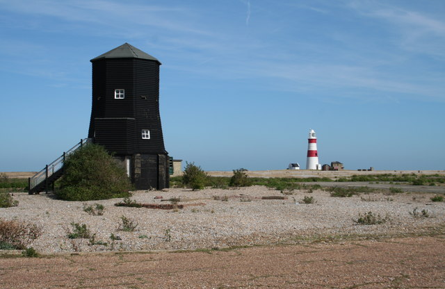
The Black Beacon radar tower and the lighthouse.
-
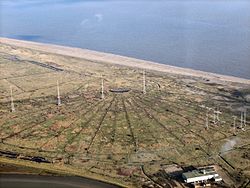
Aerial view of the Orfordness [sic] transmitting station.
-
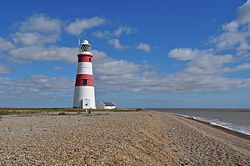
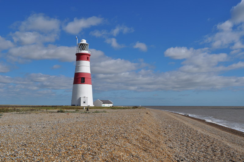
The Lighthouse
-
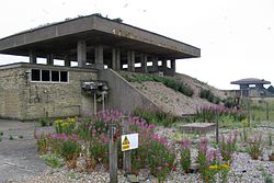
Exterior of two "pagodas".
-
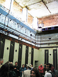
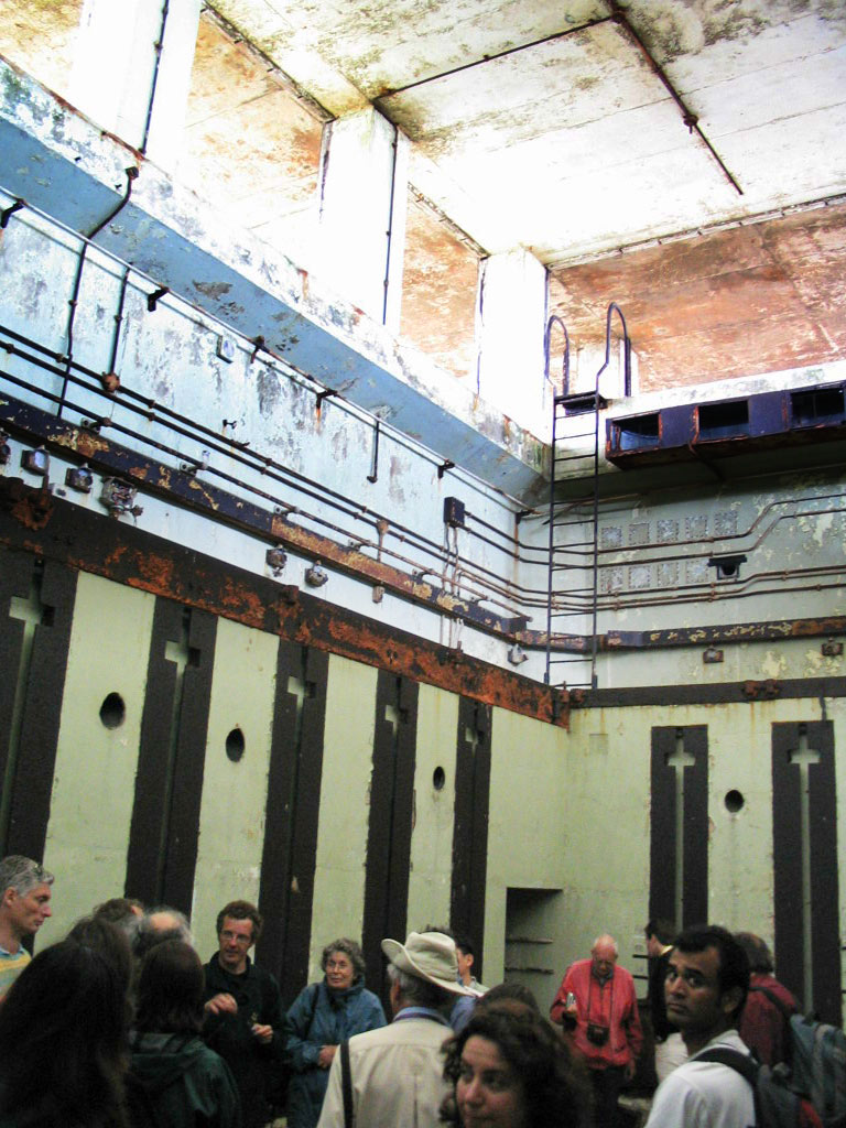
Interior of a "pagoda".
Geography
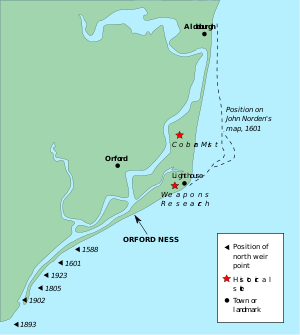 Map showing Orford Ness and historical extent.
Orford Ness is Europe's largest vegetated shingle spit.[17][18] It is approximately 10 miles (16 km) long,[19] and the site covers a total area of approximately 2,230 acres (900 ha).[20] Forty percent of this (890 acres) is shingle, 25 percent (556 acres) tidal rivers, mud flats, sand flats, and lagoons, eighteen percent (400 acres) grassland, and fifteen percent (330 acres) salt marsh.[20]
The spit formed almost entirely of flint deposited by waves through the process of long-shore drift. The main influence on its formation has been storm waves throwing shingle over the top of the beach crest, where it is protected from ordinary wave action.[17] Over time, this process leads to the formation of stable ridges of fine particles, and swails of coarser shingle.[17]
The size and shape of the spit fluctuates over time (see map). Estimated growth rates range from 64m per year in 1962 to 1967, to 183m per year in 1804 to 1812. Between 1812 and 1821, the total length fluctuated by 1.8 miles (2.9 km).[21] As a result of the dynamically changing nature of the spit, the true age of its formation is unknown.[22] However, before about 1200, Orford is thought to have been a port facing the open sea.[23]
See also
- Wartime events at Shingle Street, Suffolk, are explored in more detail in two books by James Hayward.
- Orford Castle Norman keep overlooking Orfordness and Orford Island.
- Havergate Island — RSPB Reserve
- Seaplane Experimental Station, another research station at Felixstowe
- Aeroplane and Armament Experimental Establishment, yet another nearby experimental station at Martlesham Heath Airfield
Notes and references
- ^ "Orfordness Lighthouse". Trinity House. http://www.trinityhouse.co.uk/interactive/gallery/orfordness.html.
- ^ "Coastal Vegetated Shingle". Joint Nature Conservation Committee. http://www.ukbap.org.uk/ukplans.aspx?ID=29.
- ^ "Orfordness-Havergate NNR". Natural England. http://www.english-nature.org.uk/special/nnr/nnr_details.asp?nnr_name=&C=38&Habitat=0&natural_area=&local_team=0&spotlight_reserve=0&X=&NNR_ID=124.
- ^ "Alde-Ore Estuary SSSI". Natural England. http://www.english-nature.org.uk/special/sssi/sssi_details.cfm?sssi_id=1003208.
- ^ "Alde, Ore and Butley Estuaries SAC". Joint Nature Conservation Committee. http://www.jncc.gov.uk/protectedsites/sacselection/sac.asp?EUCode=UK0030076.
- ^ "Orfordness-Shingle Street SAC". Joint Nature Conservation Committee. http://www.jncc.gov.uk/protectedsites/sacselection/sac.asp?EUCode=UK0014780.
- ^ "Alde-Ore Estuary SPA". Joint Nature Conservation Committee. http://www.jncc.gov.uk/page-1400.
- ^ "Alde-Ore Estuary Ramsar". Joint Nature Conservation Committee. http://www.jncc.gov.uk/page-1389.
- ^ "Suffolk Coasts and Heaths AONB". Natural England. http://www.countryside.gov.uk/LAR/Landscape/DL/aonbs/aonb_suffolkch.asp.
- ^ "Suffolk Heritage Coast". Natural England. http://www.countryside.gov.uk/LAR/Landscape/DL/heritage_coasts/suffolkhc.asp.
- ^ "Orfordness and Shingle Street GCR". Joint Nature Conservation Committee. http://www.jncc.gov.uk/default.aspx?page=4174&gcr=1758.
- ^ Ratcliffe, D. A. (1977). A Nature Conservation Review: the Selection of Sites of Biological National Importance to Nature Conservation in Britain. 2 Volumes.. Cambridge University Press.
- ^ "Suffolk River Valleys ESA". Department for Environment, Food and Rural Affairs. http://www.defra.gov.uk/erdp/schemes/esas/stage2/suffolkrivers.htm.
- ^ http://www.nationaltrust.org.uk/orfordness
- ^ Woodward, Rachel (October 2004). Military Geographies. Blackwell Publishing. ISBN 1-4051-2777-5.
- ^ Note: Woodward states that the testing grounds closed in the early 1990s.
- ^ a b c Evans, Paul. "The effects of nesting gulls on the shingle vegetation at Orford Ness Suffolk". School of Biological Sciences, University of East Anglia, Norwich. http://www.nationaltrust.org.uk/main/w-orfordness-guanification_report.pdf.
- ^ The name 'ness' means 'promontory'. See Toulmin Smith, Joshua (1839). The Northmen in New England, Or, America in the Tenth Century. Hilliard, Gray, & co. p. 186.
- ^ Annex 06: Orfordness in: "Coastal habitat restoration – towards good practice". English Nature. 2003. http://www.english-nature.org.uk/livingwiththesea/project_details/good_practice_guide/shingleCRR/shingleguide/Annexes/Annex06Orfordness/Index.htm.
- ^ a b "Orfordness — Shingle Street". Joint Nature Conservation Committee. January 2001. http://www.jncc.gov.uk/ProtectedSites/SACselection/n2kforms/UK0014780.pdf.
- ^ Lee, E. Mark; Higgitt, David L. (December 2001). Geomorphological Processes and Landscape Change: Britain in the Last 1000 Years. Blackwell Publishing. p. 168. ISBN 0-631-22273-1.
- ^ "Coastal vegetated shingle". National Trust. 2006. http://www.nationaltrust.org.uk/main/w-vh/w-visits/w-findaplace/w-orfordness/w-orfordness-wildlife_habitat/w-orfordness-wildlife_habitat-shingle/w-orfordness-wildlife_habitat-shingle-vegetated.htm.
- ^ Bowen, Ann; Pallister, John (November 2001). Advanced Geography for AQA Specification A. Heinemann Educational Publishers. p. 48. ISBN 0-435-35282-2.
External links
- LIFE+ project; Alde-Ore future for wildlife
- Orford Ness National Nature Reserve information at the National Trust
- Orfordness and Orford Island Boat Trips — Lady Florence, Orford Quay, Suffolk
- My Orford by Charlie Underwood - An interesting insight into village life in Orford
Categories:- Geography of Suffolk
- National Trust properties in Suffolk
- Nature Conservation Review sites
- Visitor attractions in Suffolk
- Spits of England
- Suffolk Coastal
-


Wikimedia Foundation. 2010.