- Mount Douglas (Alaska)
-
Mount Douglas 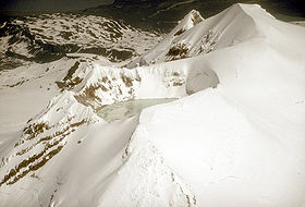
Crater lake at the summit, June 1990Elevation 7,021 ft (2,140 m) Location Location Katmai National Park and Preserve, Alaska, USA Range Aleutian Range Coordinates 58°51′36″N 153°31′59″W / 58.86°N 153.53306°W Topo map USGS Afognak D-5 Geology Type Stratovolcano Volcanic arc/belt Aleutian Arc Last eruption Holocene - For other mountains by this name, see Mount Douglas.
Mount Douglas is a stratovolcano located south of Kamishak Bay, near the northeasternmost part of the Alaska Peninsula. It lies in the Katmai National Park and Preserve in Kenai Peninsula Borough. The mountain was officially named in 1906 after nearby Cape Douglas based on a 1904 report by USGS geologist G. C. Martin. The Alaska Volcano Observatory currently rates Douglas as Level of Concern Color Code Not Assigned.
The volcano has a warm and highly acidic crater lake approximately 160 m (525 ft) wide. In 1992, the lake had a temperature of 21°C and a pH of 1.1. At the north flank of the volcano unglaciated and relatively uneroded lava flows are found. The last eruption was considered to have occurred during the Holocene (Nye et al.,1998).
 Map showing volcanoes of Alaska.
See also
- Mountain peaks of Alaska
- Mountain peaks of North America
- Mountain peaks of the United States
- List of volcanoes in the United States of America
References
Categories:- Landforms of Kenai Peninsula Borough, Alaska
- Stratovolcanoes
- Mountains of Alaska
- Volcanoes of Alaska
- Crater lakes
- Katmai National Park and Preserve
- Aleutian Range


Wikimedia Foundation. 2010.