- Calhoun, Georgia
Infobox Settlement
official_name = Calhoun, Georgia
other_name =
native_name =
nickname =
settlement_type =City
motto =
imagesize =
image_caption =
flag_size =
image_
seal_size =
image_shield =
shield_size =
image_blank_emblem =
blank_emblem_type =
blank_emblem_size =
imagesize =
image_caption =
flag_size =
image_
seal_size =
image_shield =
shield_size =
image_blank_emblem =
blank_emblem_type =
blank_emblem_size =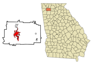
mapsize = 250px
map_caption = Location in Gordon County and the state of Georgia
mapsize1 =
map_caption1 =
image_dot_
dot_mapsize =
dot_map_caption =
dot_x =
dot_y =
pushpin_
pushpin_label_position =
pushpin_map_caption =
pushpin_mapsize =
subdivision_type = Country
subdivision_name =United States
subdivision_type1 = State
subdivision_name1 = Georgia
subdivision_type2 = County
subdivision_name2 = Gordon
subdivision_type3 =
subdivision_name3 =
subdivision_type4 =
subdivision_name4 =
government_footnotes =
government_type =
leader_title =
leader_name =
leader_title1 =
leader_name1 =
leader_title2 =
leader_name2 =
leader_title3 =
leader_name3 =
leader_title4 =
leader_name4 =
established_title =
established_date =
established_title2 =
established_date2 =
established_title3 =
established_date3 =
area_magnitude =
unit_pref =
area_footnotes =
area_total_km2 = 30.2
area_land_km2 = 30.2
area_water_km2 = 0
area_total_sq_mi = 11.7
area_land_sq_mi = 11.7
area_water_sq_mi = 0
area_water_percent =
area_urban_km2 =
area_urban_sq_mi =
area_metro_km2 =
area_metro_sq_mi =
area_blank1_title =
area_blank1_km2 =
area_blank1_sq_mi =
population_as_of = 2000
population_footnotes =
population_note =
population_total = 10667
population_density_km2 = 353.2
population_density_sq_mi = 911.7
population_metro =
population_density_metro_km2 =
population_density_metro_sq_mi =
population_urban =
population_density_urban_km2 =
population_density_urban_sq_mi =
population_blank1_title =
population_blank1 =
population_density_blank1_km2 =
population_density_blank1_sq_mi =
timezone = Eastern (EST)
utc_offset = -5
timezone_DST = EDT
utc_offset_DST = -4
latd = 34 |latm = 30 |lats = 0 |latNS = N
longd = 84 |longm = 56 |longs = 33 |longEW = W
elevation_footnotes =
elevation_m = 201
elevation_ft = 659
postal_code_type =ZIP code s
postal_code = 30701, 30703
area_code = 706
blank_name = FIPS code
blank_info = 13-12456GR|2
blank1_name = GNIS feature ID
blank1_info = 0354936GR|3
website =
footnotes =Calhoun is a
city in Gordon County, Georgia,United States . Thepopulation was 10,667 at the 2000 census. The city's rapid growth is evident as the population rose to 13,570 in 2005. [http://www.city-data.com/city/Calhoun-Georgia.html] The city is thecounty seat of Gordon CountyGR|6.Geography
Calhoun is located at coor dms|34|29|60|N|84|56|33|W|city (34.499898, -84.942584)GR|1, along the
Oostanaula River .Calhoun is located along U.S. Interstate 75, approximately 70 miles north of Atlanta, GA, and 50 miles south of Chattanooga, TN.History
Calhoun was a part of the Cherokee Nation (including
New Echota , capital of the Cherokee Nation) untilDecember 29 ,1835 . When the Cherokees refused to give up their lands, theU.S. Army was sent by President Jackson to the northern region of Georgia to force them to move toOklahoma (see more information onTrail of Tears ).After the Cherokees left their lands, Georgia claimed the Cherokee lands that became Gordon County and other counties. A small town called Dawsonville was created and founded in the Gordon County, named for the owner of an early general store. Dawsonville was later renamed Calhoun to honor
U.S. Senator John C. Calhoun , following his death in 1850.Gordon County's inferior court called an election to allow the voters to choose between a site on the
Western & Atlantic Railroad (involvingAdairsville ) or a site more centrally located within the county instead of designating the location of thecounty seat unlike other counties. Voters chose a site along the railroad, so the inferior court designated Calhoun as county seat in 1851. The legislature incorporated Calhoun in an act approved onJanuary 12 ,1852 (See Ga. Laws 1851-52, page 419 as an evidence).In
January 5 ,1861 , Georgia seceded from the Union. Calhounians joined the Confederacy during theAmerican Civil War . OnMay 16 ,1864 , Calhoun was near the center of action as Union GeneralWilliam Tecumseh Sherman and Confederate GeneralJoseph E. Johnston postured before the outbreak of theBattle of Adairsville during Sherman'sAtlanta Campaign . Oakleigh, home of Dr. Wall, was saved and used by Sherman as the headquarters at that time.Roland Hayes , a prominent African American tenor was born in nearby Curryville. Hayes achieved enormous international recognition during his career. After his death, The Roland Hayes Committee was formed in 1990 to advocate the induction of Roland Hayes into the Georgia Music Hall of Fame. In 1992, when the Calhoun-Gordon Arts Council was incorporated, the Roland Hayes Committee became the Roland Hayes Music Guild and museum.Demographics
According to the
United States Census Bureau , the city has a total area of 30.2km² (11.7 mi²). 30.2 km² (11.6 mi²) of it is land and 0.1 km² (0.04 mi²) of it (0.17%) is water.As of the
census GR|2 of 2000, there were 10,667 people, 4,049 households, and 2,672 families residing in the city. Thepopulation density was 353.5/km² (915.4/mi²). There were 4,298 housing units at an average density of 142.4/km² (368.8/mi²). The racial makeup of the city was 77.91% White, 7.56% African American, 0.42% Native American, 1.00% Asian, 0.14% Pacific Islander, 11.61% from other races, and 1.36% from two or more races. 17.07% of the population was Hispanic or Latino of any race.There were 4,049 households out of which 30.9% had children under the age of 18 living with them, 47.8% were married couples living together, 13.9% had a female householder with no husband present, and 34.0% were non-families. 28.8% of all households were made up of individuals and 12.0% had someone living alone who was 65 years of age or older. The average household size was 2.56 and the average family size was 3.07.
In the city the population was spread out with 24.2% under the age of 18, 11.2% from 18 to 24, 31.0% from 25 to 44, 20.1% from 45 to 64, and 13.5% who were 65 years of age or older. The median age was 34 years. For every 100 females there were 98.9 males. For every 100 females age 18 and over, there were 96.7 males.
The median income for a household in the city was $33,618, and the median income for a family was $42,310. Males had a median income of $27,616 versus $25,018 for females. The
per capita income for the city was $19,887. About 12.5% of families and 16.8% of the population were below thepoverty line , including 20.8% of those under age 18 and 19.1% of those age 65 or over.Calhoun is a home of
New Echota Historic Site, a museum of Cherokee Nation capital, Roland Hayes Museum (Calhoun Gordon Arts Council/The Harris Arts Center) and Oakleigh, the home of the Gordon County Historical Society used to be General Sherman's Headquarters.Calhoun also has one of three
Coosa Valley Technical College campuses among Rome and Rockmart, GeorgiaEducation
[http://www.calhounschools.org/Schools/tabid/54/Default.aspx Calhoun City Schools]
*Calhoun Primary School
*Calhoun Elementary School
*Calhoun Middle School
*Calhoun High SchoolRadio and TV
Calhoun, Georgia is located in the
Atlanta television market, the ninth largest DMA according toNielsen Media Research . Cable TV service is offered throughComcast Cable which provides one community access channel WEBS cable 3.There are three radio stations serving Calhoun.
WEBS 1030am / Cable Channel 3 / Oldies {www.webs1030am.com}
WJTH 900am / Country
WJTH 101.7FM / Country
WLOJ 102.9fm / Religious (owned and operated by the
Calhoun Seventh-day Adventist Church )There is also a semi-weekly Newspaper, [http://www.calhountimes.com The Calhoun Times]
References
External links
* [http://www.cityofcalhoun-ga.com Calhoun, Georgia web site]
* [http://ngeorgia.com/parks/new.html Echota Historic Site web site]
* [http://cgarts.org/ Calhoun-Gordon Arts Council web site]
* [http://cgarts.org/roland.html Roland Hayes Museum web site]
* [http://www.calhountimes.com Calhoun Times website]
Wikimedia Foundation. 2010.