- History of New York City transportation
The History of the New York City Transportation System ranges from strong Dutch authority in the
17th Century , expansionism during the industrial era in the19th century and half of the20th Century , to outrightcronyism during the failures of theRobert Moses era. The shape of the city's transportation system changed as city did, and the result is an impressive modern-day system of industrial-era infrastructure.In Dutch Nieuw Amsterdam
Portions of the street that would eventually host eleven subway lines [cite web |url= http://mta.info/nyct/maps/submap.htm |title=MTA NYC Transit – Subway Service Information|work=Michael Hertz Associates, NYC|publisher=Metropolitan Transportation Authority] , become slang for the 20th century theater industry, and run through some of the highest priced real estate of the nation, was once a primary route of the
Lenape people in Pre-Dutch New York, according to Burrows, et al. [cite book|last=Burrows|first=et al.|title=Gotham|publisher=Oxford Press|date=1999|isbn=0195116348] This route, part of which is present-day Broadway, ran fromthe Battery , through the East Side, and exited out of what was the northernmost point of Manhattan, in present-dayMarble Hill . Broadway was not the only former Lenape trail route;Jamaica Avenue , which connects the present-day boroughs ofBrooklyn andQueens , runs along a former trail throughJamaica Pass . According to Homberger, present-dayLafayette Street , Park Row, and St. Nicholas Avenue also follow former Lenape routes. [cite book|last=Homberger|first=Eric|title=The Historical Atlas of New York City: A Visual Celebration of Nearly 400 Years of New York City's History|publisher=Henry Holt and Company, LLC|date=1998|isbn=0805060049] According to Burrow, et al., [cite book|last=Burrows|first=et al.|title=Gotham|publisher=Oxford Press|date=1999|isbn=0195116348] the Dutch had decided that that Lenape trail which ran the length of Manhattan, or present-day Broadway, would be called theHeere Wegh . The first paved street in New York was authorized byPetrus Stuyvesant (Peter Stuyvesant) in 1658, to be constructed by the inhabitants of Brouwer Street (present-day Stone Street).[
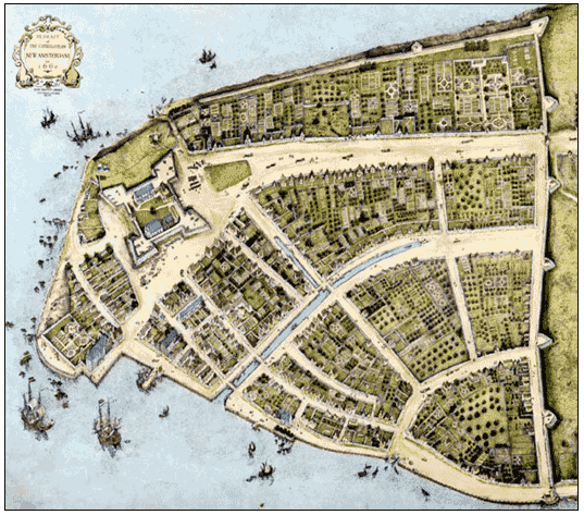
thumb|275px|The_Castello Plan illustrates the extent of Dutch ambition of trade in Nieuw Amsterdam, in the 17th Century.]The early Dutch city of
Nieuw Amsterdam (New Amsterdam) took full advantage of the rivers which surrounded the city, in some manner a foreshadowing of the empire that New York's shipping industry would establish two centuries later. According to the Castello Plan, multiplecanal s and waterways were built, including a very early canal on the present-dayBroad Street , which was called theHeere Gracht . According to Burrows, et al., [cite book|last=Burrows|first=et al.|title=Gotham|publisher=Oxford Press|date=1999|isbn=0195116348] a municipal pier was built on what is now Moore Street, on theEast River . The first regional transportation that was built out of Nieuw Amsterdam was a “wagon-road” that linked toNieuw Haarlem (Harlem ). It was built in 1658 to encourage development of that town, by order of Petrus Stuyvesant, who saw, accurately, that Nieuw Haarlem could provide an important measure of defense for Nieuw Amsterdam.British New York and earlier 19th century
The
Province of New-York greatly improved the old Indian trails that had served the colony's earlier masters. Country roads suitable for wagons included the King's Highway in Kings County, two Jamaica Roads throughJamaica Pass , andBoston Post Road . Fact|date=August 2007As new streets were laid out beyond Wall Street, the grid became more regular. The river areas being more useful, their streets were first, with streets parallel and perpendicular to their particular river. Later 18th century streets in the middle of the island were even more regular, with city blocks longer in the approximately north/south direction than east/west. By the early 19th century, urban growth had reached approximately the line of the modern Houston Street, and farther in
Greenwich Village . Fact|date=August 2007 Due to expanding world trade, growth was accelerating, and a commission created a more comprehensive street plan for the remainder of the island.New York adopted a visionary proposal to develop Manhattan north of 14th Street with a regular street grid, according to "The
Commissioners' Plan of 1811 ." This would fundamentally alter the city aesthetically, economically, and geographically. The economic logic underlying the plan - which called for twelve numbered avenues running approximately north and south, and 155 orthogonal cross streets - was that the grid's regularity would provide an efficient means to develop new real estate property and would promote commerce.Into the middle 19th century most streets remained unpaved, but tracks allowed smooth public transport by
horse car s which were eventually electrified as trolleys.Industrialization in the 19th century
Water transport grew rapidly in the new century, due in part to technical development under
Robert Fulton 's steamboat monopoly. Steamboats provided rapid, reliable connections from the harbor to other Hudson River and coastal ports, and later local steam ferries allowed commuters to live far from their workplaces. The completion in 1825 of the upstateErie Canal , spanning theHudson River andLake Erie , made New York the most important connection between Europe and the American interior. TheGowanus Canal and other works were built to handle the increased traffic, all suitable existing shorelines having already been lined with docks. TheMorris Canal andDelaware and Raritan Canal were parts of the extensive system of new infrastructure serving the city with coal and other commodities. The canal age, however, gave way to a railway age.Steam railroad s, started in places less generously endowed with waterways, soon reached New York and became a tool of the rivalry among port cities. New York with itsNew York Central Railroad came out on top, ensuring the city's continued dominance of the international trade of the interior of the United States. As the West and East sides of Manhattan became more populated, local railroads were elevated or depressed to escape road traffic, and the intercity railroads abandoned theirDowntown Manhattan stations on Chambers Street and elsewhere. Soot and an occasional shower of flaming embers from overhead steam locomotives eventually came to be regarded as a nuisance, and the railroads were converted to electric operation. A competitive network ofplank road s and surface and elevated railroads sprang up to connect and urbanize Long Island, especially the western parts.New Yorks' ports continued to grow rapidly during and after the
Second Industrial Revolution , making the city America's mouth, sucking in manufactured goods and immigrants and spewing forth grains and other raw materials to the developed countries. By the mid 19th century, thanks in part to the introduction of oceanic steamships, more passengers and products came through the Port of New York than all other harbors in the country combined.Fact|date=July 2007Designed by
John Roebling , theBrooklyn Bridge was the first link between Manhattan and the land mass of Long Island. It was notable for size, magnificance and commercial importance. The main span of 1,596' 6" was the longest span of any bridge in the world when it was completed in 1883 – a period of time that firmly established the concept of municipal consolidation among the outlying cities and suburbs into what eventually became theCity of Greater New York . TheWilliamsburg Bridge andManhattan Bridge completed the trio of architecturally-notable lowerEast River crossings in the early 20th century. These and other great bridges carried trolley cars, whose tracks and electrical wires had already spread through the metropolitan area, creating sprawlingstreetcar suburbs miles away from theinner city . Bridges after 1920, being for road vehicles only, had no tracks.Streetcars found steam power impractical, and more often progressed directly from horse power to electricity. Suburban electrification involved true trolley cars, but the required overhead wires were forbidden in New York (Manhattan).
Traffic congestion and the high cost ofconduit current collection impeded streetcar development there.New York's waterways, so useful in establishing its commerce and power, became obstacles to railroads. Freight cars had to be carried across the harbor by
car float s, contributing to harbor traffic already made heavy when many of the great new ocean steamships of the day must be served bylightering due to insufficient dock slips large enough to accommodate them. TheHarlem River being not so difficult, three railroads with service to the north agreed to build a commonGrand Central Terminal , but disagreement among New Jersey railroad companies foiled efforts to organize a great new rail bridge across the Hudson, so thePennsylvania Railroad , with its newly acquiredLong Island Rail Road subsidiary, built theNew York Tunnel Extension for its newPennsylvania Station, New York . Passengers of the other companies changed to the Pennsylvania, or continued to cross the Hudson by ferries and theHudson Tubes .The Gowanus Canal being too small to handle late 19th century barges,
Newtown Creek was similarly canalized, serving among other customers the newly translocated gas works of the newly amalgamatedBrooklyn Union Gas company on the Whale Creek tributary. Refineries and petrochemical factories followed in later decades, greatly intensifying the industrialization of Greenpoint,Bushwick ,Maspeth and other outlying former villages in the newly amalgamatedCity of Greater New York . Greenpoint remained a center of the fuel trade beyond the 20th century.Workaday purposes were not the only ones pursued on the waters. Mark Twain's "
Innocents Abroad " recounts one of the firstcruise ship voyages out of Brooklyn in the 1860s for rich people, while theGeneral Slocum disaster points out the late 19th and early 20th century habit of organizing day excursions for humbler folk. Some trips went to amusement parks or other attractions, and some merely to a dock with a footpath to a meadow for dancing, picnicking and other pleasures made more pleasurable by absence from the hectic, noisy city.Day-tripper s visited the Great Falls of thePassaic River and other tourist attractions by railroad and sometimes by organizedbicycle tours . Hudson River Day Line was the last company doing regularly scheduled day trips from West 42d Street; they went out of business in the 1970s.New York was not the first to develop rapid transit in the United States, but soon caught up. Elevated trains were introduced in the 1880s, and late in the century parts of some trolley lines were placed underground. In 1904, the first subway line became operational.
Post-Industrialization
Early in the 20th Century the Department of Dock and Ferries built a series of piers south of 23rd Street to handle the ever-growing traffic of oceanic passenger steamships, which was later called
Chelsea Piers .John D. Hertz started theYellow Cab Company in 1915, which operated hireable vehicles in a number of cities including New York. Hertz painted his cabs yellow after he had read a study that identified yellow as being the most visible color from a long distance. In 1967, New York City ordered all "medallion taxis" be painted yellow.cite news|title=Taxi Dreams|author=PBS and WNET|date=2001-08|url=http://www.pbs.org/wnet/taxidreams/data/index.html|accessdate=2007-02-18]The increased use of private
automobile s greatly affected all transportation projects built more or less after 1930. In 1927, theHolland Tunnel , built under the Hudson River, was the first mechanically ventilated vehicular tunnel in the world. The Lincoln and Holland tunnels were built instead of bridges to allow free passage of large passenger and cargo ships in the port, which were still critical for New York City's industry through the early- to mid-20th century. Other 20th century bridges and tunnels crossed the East River, and theGeorge Washington Bridge was higher up the Hudson.Mayor
Fiorello H. La Guardia presided over the construction of theIndependent Subway System started by his predecessors, and promoted an airport in Brooklyn and two larger ones in Queens. The Queens airports grew and prospered in later decades, but construction of new subways came to a virtual standstill after the 1950s, proposed expansions being first deferred and then scaled back.Mayor La Guardia appointed a dynamic young
Robert Moses as Commissioner of Parks who, in the West Side Improvement, separated the freight service of theWest Side Line (NYCRR) from street life, to the benefit of both and of parks. Later, Moses extendedparkway s beyond previous limits. After 1950 the federal government's priority shifted tofreeways , and Moses applied his usual vigor to that kind of construction.Hudson River crossings were in the charge of the
Port of New York Authority , which also took control of freight piers and built a grain elevator inRed Hook, Brooklyn . The Port Authority oversaw the transition of the ocean cargo industry from North Riverbreak bulk operations tocontainerization ports, mostly onNewark Bay , built a Downtown truck terminal on Greenwich Street and Midtown bus terminal, and took over the financially ailingHudson Tubes that carried commuters from Hudson and Essex Counties in New Jersey to Manhattan. Plans for aCross-Harbor Rail Tunnel to replace the decliningcar float operations of the railroads did not come to fruition; instead most land freight traffic converted to trucks. The Port Authority also took over and expanded the major airports owned by the Cities of New York andNewark, New Jersey .In 1944, at the height of World War II, the port became the busiest port in world history.Fact|date=July 2007
A catalyst for expressways and suburbs, but a nemesis for environmentalists and politicians alike,
Robert Moses was a critical figure in reshaping the very surface of New York, adapting it to the changed methods of transportation after 1930. Beyond designing a series of limited-accessparkway s in four boroughs, which were originally designed to connect New York City to its more rural suburbs, Moses also conceived and established numerous public institutions, large-scale parks, and more. [cite book|last=Caro|first=Robert A.|title=The Power Broker; Robert Moses and the Fall of New York|publisher=Vintage Books|date=1975|isbn=0394720245] With one exception, Moses had conceptualized and planned every single highway, parkway, expressway, tunnel or other major road in and around New York City; that exception being theEast River Drive . All 416 miles of parkway were also designed by Moses. Between 1931 and 1968, seven bridges were built between Manhattan and the surrounding land, including theTriborough Bridge , and theBronx-Whitestone Bridge . TheVerrazano-Narrows Bridge connectingBrooklyn andStaten Island , was the longest suspension bridge in the world when it was completed in 1964. In addition, Moses was critical in designing several tunnels around the city; these included theQueens Midtown Tunnel , which was the largest non-Federal project in 1940, and theBrooklyn-Battery Tunnel in 1950.In the 1950s, New York's passenger ship docks in the West 20s were replaced by a modern
New York Passenger Ship Terminal in the West 50s, in time for a great increase of ocean passenger service. The Terminal was extensively renovated in the 1970s, in time for the virtual disappearance of the transatlantic steamship trade.References
Wikimedia Foundation. 2010.