- Cold Hesledon
-
 Dalton Pumping Station
Cold Hesledon is a village in County Durham, in England. It is situated a short distance to the east of Murton.
Contents
Dalton Pumping Station
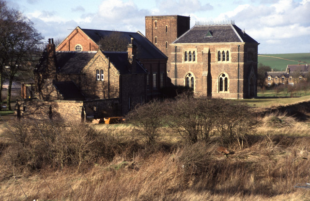
Within the village is a large Victorian, Gothic Revival former Water pumping station, designed by Thomas Hawksley for the Sunderland and South Shields Water Company.[1] The engine house contains a pair of 72" single-acting non-rotative Cornish beam engines by Davy Bros of Sheffield, dating from the 1870s when the complex was built. (Pumping engines of this period were more often of a double-acting rotative design (as seen at nearby Ryhope); the use of Cornish engines here seems to be due to the great depth of the well - some 450 feet.) The site suffered for many years from subsidence due to nearby mine workings; this in part led to the engines being decommissioned in the 1940s, and to the demolition in the 1960s of the striking campanile-like top section of the central tower/chimney. (The surviving chimney tower at Bestwood Notts., by the same architect, is of an almost identical design.)
The pumping station site was bought in 1995 with a view by its owners to transform it into a pub; however the building became Grade II* listed, which allegedly stopped its development. Other options are now being explored by the owners.[2]
Other notable landmarks
Nearby is Dalton Tower, a ruined tower house.
Coordinates: 54°49′N 1°21′W / 54.817°N 1.35°W
References
External links
Categories:- Villages in County Durham
- Preserved stationary steam engines
- Preserved beam engines
- Pumping stations
- Buildings and structures in County Durham
- County Durham geography stubs
Wikimedia Foundation. 2010.