- Estero, Florida
Infobox Settlement
official_name = Estero, Florida
other_name =
native_name =
nickname =
settlement_type = CDP
motto =
imagesize =
image_caption =
flag_size =
image_
seal_size =
image_shield =
shield_size =
image_blank_emblem =
blank_emblem_type =
blank_emblem_size =
imagesize =
image_caption =
flag_size =
image_
seal_size =
image_shield =
shield_size =
image_blank_emblem =
blank_emblem_type =
blank_emblem_size =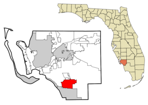
mapsize = 250x200px
map_caption = Location in Lee County and the state ofFlorida
mapsize1 =
map_caption1 =
image_dot_
dot_mapsize =
dot_map_caption =
dot_x =
dot_y =
pushpin_
pushpin_label_position =
pushpin_map_caption =
pushpin_mapsize =
subdivision_type = Country
subdivision_name = flag|United States
subdivision_type1 = State
subdivision_name1 = flag|Florida
subdivision_type2 = County
subdivision_name2 = noflag|Lee
subdivision_type3 =
subdivision_name3 =
subdivision_type4 =
subdivision_name4 =
government_footnotes =
government_type =
leader_title =
leader_name =
leader_title1 =
leader_name1 =
leader_title2 =
leader_name2 =
leader_title3 =
leader_name3 =
leader_title4 =
leader_name4 =
established_title =
established_date =
established_title2 =
established_date2 =
established_title3 =
established_date3 =
area_magnitude =
unit_pref = Imperial
area_footnotes =
area_total_km2 = 54.7
area_land_km2 = 54.6
area_water_km2 = 0.1
area_total_sq_mi = 21.1
area_land_sq_mi = 21.1
area_water_sq_mi = 0
area_water_percent =
area_urban_km2 =
area_urban_sq_mi =
area_metro_km2 =
area_metro_sq_mi =
area_blank1_title =
area_blank1_km2 =
area_blank1_sq_mi =
population_as_of = 2000
population_footnotes =
population_note =
population_total = 9503
population_density_km2 = 173.7
population_density_sq_mi = 450.4
population_metro =
population_density_metro_km2 =
population_density_metro_sq_mi =
population_urban =
population_density_urban_km2 =
population_density_urban_sq_mi =
population_blank1_title =
population_blank1 =
population_density_blank1_km2 =
population_density_blank1_sq_mi =
timezone = Eastern (EST)
utc_offset = -5
timezone_DST = EDT
utc_offset_DST = -4
latd = 26 |latm = 25 |lats = 56 |latNS = N
longd = 81 |longm = 48 |longs = 34 |longEW = W
elevation_footnotes =
elevation_m = 4
elevation_ft = 13
postal_code_type =ZIP code
postal_code = 33928
area_code = 239
blank_name = FIPS code
blank_info = 12-21150GR|2
blank1_name = GNIS feature ID
blank1_info = 0282257GR|3
website =
footnotes =Estero is a
census-designated place (CDP) in Lee County,Florida ,United States . As of the 2000 census, the CDP population was 9,503. It is the home ofGermain Arena , which hosts the home games for theFlorida Everblades ECHL hockey team and theFlorida Firecats af2 arena football team.Florida Gulf Coast University is also located just outside of the Estero Planning District. [ [http://esterofl.org/EsteroLife/map_of_estero.htm Map of Estero Planning District] ]Geography
Estero is located at coor dms|26|25|56|N|81|48|34|W|city (26.432237, -81.809447)GR|1.
According to the
United States Census Bureau , the CDP has a total area of 21.1 square miles (54.7 km²), of which, 21.1 square miles (54.6 km²) of it is land and 0.1 square miles (0.1 km²) of it (0.24%) is water.Historically and culturally, the heart of Estero is the spring-fed
Estero River , which flows to Estero Bay. Some of the earliest European settlers of the area (notably the Alvarez, Fernandez, Johnson, and Soto families) were fishing families that lived on Mound Key, amangrove -ringed island that dominates Estero Bay. During the early 20th century, these families moved upriver to the settlement which came to be known as Estero. Estero is also the location of autopian community called theKoreshan Unity , which is now preserved as theKoreshan State Historic Site . Until the 1970s, most settlement and development in Estero was near the river.The borders of the area of Estero include Estero Bay to the west, the city of
Bonita Springs to the south and the remainder of the CDP bordering with unincorporated Lee County and the CDP ofSan Carlos Park .Demographics
As of the
census GR|2 of 2000, there were 9,503 people, 4,608 households, and 3,336 families residing in the CDP. Thepopulation density was 450.7 people per square mile (174.1/km²). There were 7,345 housing units at an average density of 348.4/sq mi (134.5/km²). The racial makeup of the CDP was 97.43% White, 0.64% African American, 0.11% Native American, 0.35% Asian, 0.01% Pacific Islander, 0.77% from other races, and 0.69% from two or more races. Hispanic or Latino of any race were 3.19% of the population.There were 4,608 households out of which 10.0% had children under the age of 18 living with them, 68.2% were married couples living together, 2.8% had a female householder with no husband present, and 27.6% were non-families. 23.4% of all households were made up of individuals and 12.4% had someone living alone who was 65 years of age or older. The average household size was 2.01 and the average family size was 2.31.
In the CDP the population was spread out with 9.2% under the age of 18, 4.9% from 18 to 24, 14.1% from 25 to 44, 31.1% from 45 to 64, and 40.6% who were 65 years of age or older. The median age was 61 years. For every 100 females there were 93.1 males. For every 100 females age 18 and over, there were 92.6 males.
The median income for a household in the CDP was $43,734, and the median income for a family was $51,227. Males had a median income of $38,886 versus $27,883 for females. The
per capita income for the CDP was $30,521. About 1.9% of families and 3.2% of the population were below thepoverty line , including 1.1% of those under age 18 and 3.2% of those age 65 or over.History
Estero was established and incorporated by the followers of Dr. Cyrus Reed Teed, who proposed a theory of that we live on the inside of the Earth's outer skin, and that celestial bodies are all contained inside the hollow Earth. This theory, which he called
Koreshan Unity , drew followers to purchase and occupy a convert|320|acre|km2|sing=on tract in 1894. They were business-oriented and lived communally, prospering enough to found its own political party ("The Progressive Liberty Party") and incorporate the town in 1904 as Estero. The 1908 death of Dr. Teed (who claimed to be immortal) was a critical blow to the group's faith, whose membership dwindled into the 1960s. The Foundation remains as "The College of Life Foundation," which contributed (for example) at least $25,000 to the Gulf Shore Playhouse in or around 2007 [ [http://www.gulfshoreplayhouse.org/sponsors.htm Donors' page for the Gulf Shore Playhouse, showing College of Life Foundation donation as of 21 April 2008] ] . The Koreshans' original tract is now owned by Florida as the Koreshan State Park.References
External links
* [http://www.lee-county.com/ Lee County Government]
* [http://www.esterochamber.org/ Estero Chamber of Commerce]
* [http://www.lee.k12.fl.us/schools/est/ Estero High School]
* [http://www.weirdus.com/stories/FL02.asp History of Estero's founding by Koreshans]
* [http://www.esterofl.org Estero, Florida Community Organizations]Cultural Attractions
:* [http://www.germainarena.com Germain Arena] :* [http://www.fgcu.edu Florida Gulf Coast University]
Wikimedia Foundation. 2010.