- Lake Magdalene, Florida
Infobox Settlement
official_name = Lake Magdalene, Florida
other_name =
native_name =
nickname =
settlement_type = CDP
motto =
imagesize =
image_caption =
flag_size =
image_
seal_size =
image_shield =
shield_size =
image_blank_emblem =
blank_emblem_type =
blank_emblem_size =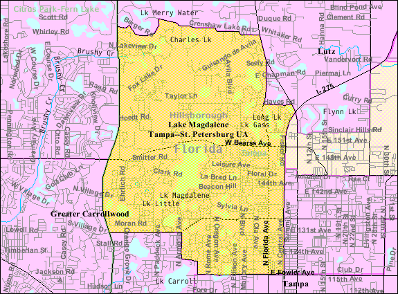
mapsize = 250px
map_caption =
mapsize1 = 250x200px
map_caption1 = Location in Hillsborough County and the state ofFlorida
image_dot_
dot_mapsize =
dot_map_caption =
dot_x =
dot_y =
pushpin_
pushpin_label_position =
pushpin_map_caption =
pushpin_mapsize =
subdivision_type = Country
subdivision_name = flag|United States
subdivision_type1 = State
subdivision_name1 = flag|Florida
subdivision_type2 = County
subdivision_name2 = noflag|Hillsborough
subdivision_type3 =
subdivision_name3 =
subdivision_type4 =
subdivision_name4 =
government_footnotes =
government_type =
leader_title =
leader_name =
leader_title1 =
leader_name1 =
leader_title2 =
leader_name2 =
leader_title3 =
leader_name3 =
leader_title4 =
leader_name4 =
established_title =
established_date =
established_title2 =
established_date2 =
established_title3 =
established_date3 =
area_magnitude =
unit_pref = Imperial
area_footnotes =
area_total_km2 = 30.3
area_land_km2 = 27.4
area_water_km2 = 2.9
area_total_sq_mi = 11.7
area_land_sq_mi = 10.6
area_water_sq_mi = 1.1
area_water_percent =
area_urban_km2 =
area_urban_sq_mi =
area_metro_km2 =
area_metro_sq_mi =
area_blank1_title =
area_blank1_km2 =
area_blank1_sq_mi =
population_as_of = 2000
population_footnotes =
population_note =
population_total = 28755
population_density_km2 = 949
population_density_sq_mi = 2457.7
population_metro =
population_density_metro_km2 =
population_density_metro_sq_mi =
population_urban =
population_density_urban_km2 =
population_density_urban_sq_mi =
population_blank1_title =
population_blank1 =
population_density_blank1_km2 =
population_density_blank1_sq_mi =
timezone = Eastern (EST)
utc_offset = -5
timezone_DST = EDT
utc_offset_DST = -4
latd = 28 |latm = 4 |lats = 53 |latNS = N
longd = 82 |longm = 28 |longs = 41 |longEW = W
elevation_footnotes =
elevation_m = 14
elevation_ft = 46
postal_code_type =
postal_code =
area_code =
blank_name = FIPS code
blank_info = 12-38350GR|2
blank1_name = GNIS feature ID
blank1_info = 1867163GR|3
website =
footnotes =Lake Magdalene is an unincorporated
census-designated place in Hillsborough County,Florida ,United States . The population was 28,755 at the 2000 census.Geography
Lake Magdalene is located at coor dms|28|4|53|N|82|28|41|W|city (28.081294, -82.477945)GR|1.
According to the
United States Census Bureau , the community has a total area of 11.7square mile s (30.3km² ), of which, 10.6 square miles (27.4 km²) of it is land and 1.1 square miles (2.9 km²) of it (9.50%) is water.ZIP codes for Lake Magdalene
ZIP code s that serve Lake Magdalene are 33612 , 33613 and 33618.Demographics
As of the
census GR|2 of 2000, there were 28,755 people, 12,085 households, and 7,722 families residing in the community. Thepopulation density was 2,718.9 people per square mile (1,049.4/km²). There were 12,938 housing units at an average density of 1,223.3/sq mi (472.2/km²). The racial makeup of the community was 86.65% White, 5.91% African American, 0.35% Native American, 2.33% Asian, 0.03% Pacific Islander, 2.64% from other races, and 2.09% from two or more races. Hispanic or Latino of any race were 13.51% of the population.There were 12,085 households out of which 28.9% had children under the age of 18 living with them, 49.5% were married couples living together, 10.9% had a female householder with no husband present, and 36.1% were non-families. 28.9% of all households were made up of individuals and 8.6% had someone living alone who was 65 years of age or older. The average household size was 2.35 and the average family size was 2.93.
In the community the population was spread out with 22.5% under the age of 18, 7.9% from 18 to 24, 29.9% from 25 to 44, 26.8% from 45 to 64, and 13.0% who were 65 years of age or older. The median age was 39 years. For every 100 females there were 91.7 males. For every 100 females age 18 and over, there were 89.7 males.
The median income for a household in the community was $43,259, and the median income for a family was $54,276. Males had a median income of $39,556 versus $30,398 for females. The
per capita income for the community was $26,685. About 5.6% of families and 7.2% of the population were below thepoverty line , including 8.6% of those under age 18 and 8.1% of those age 65 or over.Politically, Lake Magdalene is part of
congressional district s 9 and 11 [http://www.census.gov/geo/www/cd109th/FL/plc_c9_12.pdf] .History
As a northwestern suburb of Tampa, this area of Hillsborough County had welcomed enough residents to receive its first post office in
1888 , followed by a scattering of schools and churches--most notably the United Brethren Church (now [http://www.lmumc.org/templates/cuslakemagdelene/default.asp?id=34504 Lake Magdalene United Methodist] ) started in1895 by Reverend Isaac W. Bearss, whose family line still maintains several acres of citrus groves in the region, butted up against the busy east-west, North Tampa corridor that bears the family name [http://www.hillsborough.wateratlas.usf.edu/upload/documents/HILLSBOROUGH_COUNTY_Historic_Resources_Excerpts_Magdalene.pdf] [http://www.saintpetersburgtimes.com/News/121500/news_pf/Northoftampa/Pioneers_amid_progres.shtml] . The rustic qualities of Lake Magdalene remained until the 1960's when residential construction in Tampa pushed northward. By 1990 almost 16,000 people lived in Lake Magdalene [http://www.hillsborough.wateratlas.usf.edu/upload/documents/HILLSBOROUGH_COUNTY_Historic_Resources_Excerpts_Magdalene.pdf] , and according to the 2000 census, its population had nearly doubled at 28,755 [http://factfinder.census.gov/servlet/SAFFFacts?_event=Search&geo_id=&_geoContext=&_street=&_county=lake+magdalene&_cityTown=lake+magdalene&_state=04000US12&_zip=&_lang=en&_sse=on&pctxt=fph&pgsl=010&show_2003_tab=&redirect=Y] .Lake Magdalene is surrounded by, and takes its name from, a 206-acre freshwater lake [http://www.hillsborough.wateratlas.usf.edu/lake/default.asp?wbodyid=5168&wbodyatlas=lake] . One legend has it that Lake Magdalene was named after Mary Magdalene, friend and follower of Jesus, who once appeared to a settler family along the waters of the lake. However, by other more documented accounts, the lake's designation borrows from the moniker of a Native American woman, Magdalena, who interpreted the language for a Spanish expedition into Florida in
1549 [http://www.hillsborough.wateratlas.usf.edu/upload/documents/HILLSBOROUGH_COUNTY_Historic_Resources_Excerpts_Magdalene.pdf] , or even more likely, the name comes from the1882 marriage of John Parrish and Mary Magdalene Yates, daughter of Jonah Yates, first mayor of Plant City in the Lake Magdalene section of Hillsborough County [http://www.hillsborough.wateratlas.usf.edu/upload/documents/History_Name_Lake_Magalene.pdf] .Lake Magdalene's Population History
*1970.......9,266
*1980......13,331
*1990......15,973
*2000......28,755References
External links

Wikimedia Foundation. 2010.