Ershuei, Changhua — Ershuei (二水鄉) is a rural township in southeastern Changhua County, Taiwan. It is bordered on the north by Tianjhong Township , to the east by Mingjian Township in Nantou County, and to the west by Sijhou Township. Its name means, literally, Two… … Wikipedia
Chianan Plain — The Chianan Plain or Jianan Plain (Chinese: 嘉南平原) is an alluvial plain located at the central southern region of western Taiwan. It is the largest plain of the island,[1] and lies in Tainan City and Chiayi Cou … Wikipedia
Beidou, Changhua — Beidou Township (北斗鎮) is a town in Changhua County, Taiwan. It is famous for ba wan, a popular Taiwanese food item that was invented in the township. It is located in an alluvial plain in the southeast part of the county … Wikipedia
Geography of Taiwan — Taiwan Native name: 臺灣 or 台灣 Map of Taiwan … Wikipedia
Central Mountain Range — from the airplane. The Central Mountain Range, also known as the Chungyang Range (Chinese: 中央山脈; pinyin: Zhōngyāng Shānmò; Wade–Giles: Chung yang Sh … Wikipedia
Haian Range — Location of Haian Range. Haian Range. A view from the Huatung Valley … Wikipedia
Chilung Volcano Group — Chilungshan (基隆山), one of the volcanoes, has a height of 588 m. Chilung Volcanoes (Chinese: 基隆火山群), a group of volcanoes located at northern Taiwan, is just lies on the east of Taipei and Keelung (Chilung), and adjoins the northern coast of the… … Wikipedia
Tatun Volcano Group — Chihsingshan (七星山), the highest peak of these volcanoes, has a height of 1120 m. Tatun Volcanoes (Chinese: 大屯火山群), a volcanic group of volcanoes located at northern Taiwan, is located 15 km[1] n … Wikipedia
Miaoli Hills — (Chinese: 苗栗丘陵) is an area of hills stretching across the Miaoli County of central northern Taiwan. The hills is lies on the south of Hsinchu Hills and on the north of Taichung. It is extended from the Hsuehshan Mountain Range as a part of… … Wikipedia
Dadu Plateau — Tatu Plateau Dadu Plateau (Chinese: 大肚台地), also known as the Dadu Mountain or Dadushan (大肚山), stretches across the Taichung City of the central western Taiwan. It faces the Taichung Basin on the east and the seacoast of Taichung on the west, and… … Wikipedia
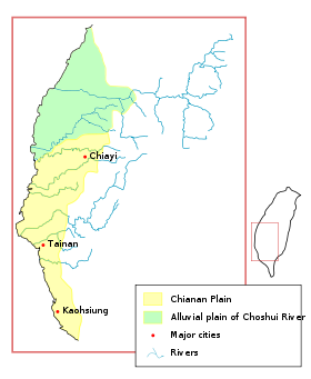 Changhua Plain (colored green) is a part of the Chianan Plain (colored yellow) in a broad sense. The borders of plains in this image are in accordance with the groundwater zones of Taiwan.
