- Haxtun, Colorado
Infobox Settlement
official_name = Town of Haxtun, Colorado
other_name =
native_name =
nickname =
settlement_type = Town
motto =
imagesize =
image_caption =
flag_size =
image_
seal_size =
image_shield =
shield_size =
image_blank_emblem =
blank_emblem_type =
blank_emblem_size =
imagesize =
image_caption =
flag_size =
image_
seal_size =
image_shield =
shield_size =
image_blank_emblem =
blank_emblem_type =
blank_emblem_size =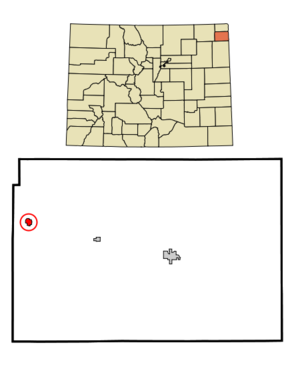
mapsize = 250px
map_caption = Location in Phillips County and the state ofColorado
mapsize1 =
map_caption1 =
image_dot_
dot_mapsize =
dot_map_caption =
dot_x =
dot_y =
pushpin_
pushpin_label_position =
pushpin_map_caption =
pushpin_mapsize =
subdivision_type = Country
subdivision_name = USA
subdivision_type1 = State
subdivision_name1 = flag|Colorado
subdivision_type2 = Countycite web | url = http://www.dola.state.co.us/dlg/local_governments/municipalities.html | title = Active Colorado Municipalities | format =HTML | publisher = State of Colorado, Department of Local Affairs | accessdate = 2007-09-01]
subdivision_name2 = Phillips
subdivision_type3 =
subdivision_name3 =
subdivision_type4 =
subdivision_name4 =
government_footnotes =
government_type = Statutory Town
leader_title =
leader_name =
leader_title1 =
leader_name1 =
leader_title2 =
leader_name2 =
leader_title3 =
leader_name3 =
leader_title4 =
leader_name4 =
established_title =
established_date =
established_title2 = Incorporated (town)
established_date2 =July 30 ,1909 cite web | url = http://www.colorado.gov/dpa/doit/archives/muninc.html | title = Colorado Municipal Incorporations | format =HTML | publisher = State of Colorado, Department of Personnel & Administration, Colorado State Archives | date =2004-12-01 | accessdate = 2007-09-02]
established_title3 =
established_date3 =
area_magnitude =
unit_pref = Imperial
area_footnotes =
area_total_km2 = 1.3
area_land_km2 = 1.3
area_water_km2 = 0
area_total_sq_mi = 0.5
area_land_sq_mi = 0.5
area_water_sq_mi = 0
area_water_percent =
area_urban_km2 =
area_urban_sq_mi =
area_metro_km2 =
area_metro_sq_mi =
area_blank1_title =
area_blank1_km2 =
area_blank1_sq_mi =
population_as_of = 2000
population_footnotes =
population_note =
population_total = 982
population_density_km2 = 755.4
population_density_sq_mi = 1964
population_metro =
population_density_metro_km2 =
population_density_metro_sq_mi =
population_urban =
population_density_urban_km2 =
population_density_urban_sq_mi =
population_blank1_title =
population_blank1 =
population_density_blank1_km2 =
population_density_blank1_sq_mi =
timezone = MST
utc_offset = -7
timezone_DST = MDT
utc_offset_DST = -6
latd = 40 |latm = 38 |lats = 30 |latNS = N
longd = 102 |longm = 37 |longs = 44 |longEW = W
elevation_footnotes = GR|3
elevation_m = 1228
elevation_ft = 4029
postal_code_type =ZIP code cite web | url = http://zip4.usps.com/zip4/citytown.jsp | title = ZIP Code Lookup| format =JavaScript /HTML | publisher =United States Postal Service | accessdate = September 30 | accessyear = 2007]
postal_code = 80731
area_code = 970
blank_name = FIPS code
blank_info = 08-34960
blank1_name = GNIS feature ID
blank1_info = 0204719
website =
footnotes =Haxtun is a Statutory Town in Phillips County,
Colorado ,United States . The population was 982 at the 2000 census.Geography
Haxtun is located at coor dms|40|38|30|N|102|37|44|W|city (40.641726, -102.628910)GR|1.
According to the
United States Census Bureau , the town has a total area of 0.5square mile s (1.3km² ), all of it land.Demographics
As of the
census GR|2 of 2000, there were 982 people, 418 households, and 267 families residing in the town. Thepopulation density was 1,963.0 people per square mile (758.3/km²). There were 490 housing units at an average density of 979.5/sq mi (378.4/km²). The racial makeup of the town was 97.15% White, 0.10% African American, 0.51% Native American, 0.41% Asian, 0.10% Pacific Islander, 0.41% from other races, and 1.32% from two or more races. Hispanic or Latino of any race were 2.04% of the population.There were 418 households out of which 28.2% had children under the age of 18 living with them, 53.6% were married couples living together, 6.2% had a female householder with no husband present, and 35.9% were non-families. 32.1% of all households were made up of individuals and 19.6% had someone living alone who was 65 years of age or older. The average household size was 2.26 and the average family size was 2.83.
In the town the population was spread out with 22.8% under the age of 18, 5.7% from 18 to 24, 22.5% from 25 to 44, 21.0% from 45 to 64, and 28.0% who were 65 years of age or older. The median age was 44 years. For every 100 females there were 87.4 males. For every 100 females age 18 and over, there were 87.2 males.
The median income for a household in the town was $30,625, and the median income for a family was $38,906. Males had a median income of $31,190 versus $19,519 for females. The
per capita income for the town was $16,370. About 6.3% of families and 12.4% of the population were below thepoverty line , including 13.9% of those under age 18 and 8.6% of those age 65 or over.References
External links
* [http://www.cmca.gen.co.us/Municipality.cfm?MunicipalityID=110 Town of Haxtun contacts]
** [http://www.dot.state.co.us/App_DTD_DataAccess/Downloads/CityMaps/Haxtun.pdf CDOT map of the Town of Haxtun]
Wikimedia Foundation. 2010.