- Cornberg
-
Cornberg 

 CornbergLocation of Cornberg within Hersfeld-Rotenburg district
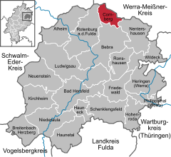

Coordinates 51°3′N 9°52′E / 51.05°N 9.86667°ECoordinates: 51°3′N 9°52′E / 51.05°N 9.86667°E Administration Country Germany State Hesse Admin. region Kassel District Hersfeld-Rotenburg Municipal subdivisions 3 districts Mayor Achim Großkurth (Ind.) Basic statistics Area 23.36 km2 (9.02 sq mi) Elevation 280 - 315 m Population 1,511 (31 December 2010)[1] - Density 65 /km2 (168 /sq mi) Other information Time zone CET/CEST (UTC+1/+2) Licence plate HEF Postal code 36219 Area code 05650 Cornberg is a community in Hersfeld-Rotenburg district in northeastern Hesse, Germany. It is the district’s smallest municipality.
Contents
Geography
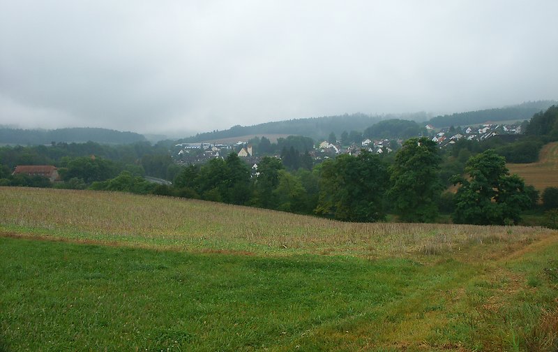
 View over Cornberg
Location
The community lies between the towns of Bad Hersfeld to the south and Eschwege to the north, each 27 km away. The municipal area lies between the Stölzinger Gebirge and the Richelsdorfer Gebirge (ranges), and in the upper reaches of the Sontra, which flows through the outlying centres of Rockensüß and Königswald. Through Cornberg itself flows the brook Cornberger Wasser, which empties into the Sontra near Berneburg (a constituent community of Sontra).
Neighbouring communities
Cornberg borders in the north on the town of Waldkappel, in the east on the town of Sontra (both in the Werra-Meißner-Kreis), in the southeast on the community of Nentershausen, in the south on the town of Bebra and in the west on the town of Rotenburg an der Fulda (all three in Hersfeld-Rotenburg).
Constituent communities
Cornberg’s Ortsteile are Cornberg, Königswald and Rockensüß.
History
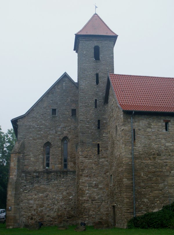
 Gothic monastery church (north wing of the cloister) with the adjoining west wing
The outlying centres of Rockensüß and Königswald had their first documentary mentions in 1274 and 1351 respectively. The village of Cornberg was founded only in 1938 as a mining settlement for Electoral-Hessian bituminous shale (Kupferschiefer) mining in the Richelsdorfer Gebirge. It is the only new settlement in the old Rotenburg an der Fulda district to arise since the Thirty Years' War.
There was however, from 1296, a Benedictine monastery here. It was long a provost’s seat of Hersfeld Abbey. The monastery was dissolved in 1526 and converted into an agricultural estate. In 1582, Philipp Wilhelm von Cornberg, a son of William IV, Landgrave of Hesse-Kassel born out of wedlock, acquired the monastery and its lands as a fief. Philipp Wilhelm sold it in 1598 to his half-brother Maurice, Landgrave of Hesse-Kassel, who transferred it in 1627 to the so-called Rotenburger Quart. It became a Vogtei that remained in the ownership of the Landgraves of Hesse-Rotenburg until they died out in 1834, whereupon it passed back to Electoral Hesse. Until 1964, the former monastery was a state domain of the Land of Hesse. The trade and dwelling buildings around the monastery, which by this time were falling into ruins, were all torn down between 1957 and 1973. Only the Gothic cloister is preserved. Between 1990 and 1994 it was restored. The former two-naved church (the cloister’s north wing) with the still preserved nuns’ gallery is used today as a cultural stage. Two other wings house the community centre and the museum. In the east wing is found a gastronomical business.
From 1945 to 1949, the whole community of Cornberg and the monastery were a UNRRA displaced persons camp mainly for forced labourers from the Soviet Union and Poland. Many of them emigrated from here to Canada and the United States. While living in Cornberg, these displaced persons lived in barracks-style accommodations, often many families to one room while they waited for final emigration clearance to their eventual homes overseas.
Politics
Community council
The municipal election held on 26 March 2006 yielded the following results:
Parties and voter communities %
2006Seats
2006%
2001Seats
2001CDU Christian Democratic Union of Germany 15.0 2 15.5 2 SPD Social Democratic Party of Germany 61.0 9 45.0 7 CBL Cornberger Bürger Liste 24.0 4 39.5 6 Total 100.0 15 100.0 15 Voter turnout in % 50.7 63.4 Mayor
The independent Achim Großkurth was elected mayor on 20 October 2002 with 52.5% of the vote. On 1 June 2008 he was reëlected with 91.7% of the vote.
Coat of arms
The community’s arms might be described thus: Party per fess, argent a lion passant gules, chequy of five gules and argent.
The community’s arms are borrowed from the family arms borne by the Barons of Cornberg, but with somewhat different tinctures. The lion passant (walking with one forepaw upraised) stands for the family’s roots, which go back to the Landgraves of Hesse (Hesse’s heraldic charge is a red-and-silver-striped lion rampant). The chequer pattern in the family’s arms stands for a chessboard, and in those arms takes the tinctures azure, gules and argent (blue, red and silver). The coat of arms was conferred upon the community on 26 February 1981.
Amalgamations
The community of Königswald was amalgamated on 11 August 1972.
Economy and infrastructure
Transport
Through the main community of Cornberg run Bundesstraße 27 and the Bebra–Göttingen railway line.
Culture and sightseeing
Museums
- Heimatkundliches Museum und Sandsteinmuseum Kloster Cornberg (local history and sandstone museum at the Cornberg monastery)
- Sandstone quarry with mineral showcases; places where prehistoric tracks of small saurians from the Permian have been found.
Buildings
- Cornberg Monastery (built 1296)
- Schloss Rittershain
References
- ^ "Die Bevölkerung der hessischen Gemeinden" (in German). Hessisches Statistisches Landesamt. 31 December 2010. http://www.statistik-hessen.de/static/publikationen/A/AI2_AII_AIII_AV_10-1hj_pdf.zip.
External links
- Cornberg’s and the Monastery’s history (German)
- Displaced persons camp in Cornberg (German)
- Cornberg at the Open Directory Project (German)
- This article incorporates information from the German Wikipedia.
Alheim | Bad Hersfeld | Bebra | Breitenbach | Cornberg | Friedewald | Hauneck | Haunetal | Heringen | Hohenroda | Kirchheim | Ludwigsau | Nentershausen | Neuenstein | Niederaula | Philippsthal | Ronshausen | Rotenburg | Schenklengsfeld | Schwarzenhasel | Wildeck Categories:
- Municipalities in Hesse


Wikimedia Foundation. 2010.