- Nioro du Sahel
-
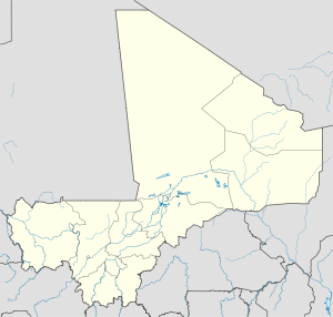
Nioro du Sahel — Commune and town — Location in Mali Coordinates: 15°11′N 9°33′W / 15.183°N 9.55°W Country  Mali
MaliRegion Kayes Region Cercle Nioro du Sahel Cercle Government - Mayor Abbas Sylla Population (1998) - Total 60,112 Time zone GMT (UTC+0) Nioro du Sahel often referred to as simply Nioro is a town and commune in the Kayes Region of western Mali, 241 km from the city of Kayes. It is located 275 miles ( by road) north-west of the capital Bamako. The commune as of 1998 had a population of 60,112 although current estimates are nearer 69,100 people.
Founded in the 16th or seventeenth century by a slave named Diawandé, Nioro attained its greatest height in the eighteenth century when it served as the capital of the Bambara kingdom of Kaarta. The town became an important trading center between Upper Senegal and the Sudan.
In the early 1850s, Toucouleur conqueror El Hadj Umar Tall invaded Kaarta, forcing the kingdom's conversion to Islam; he built a great mosque in Nioro in 1854.
The town has an airstrip at Nioro Airport.
 Communes and towns of the Kayes Region, Mali
Capital: Kayes Bafoulabé
CercleDiéma Cercle Diéma (Diéma) • Béma (Béma) • Diangounté Camara (Diangounté Camara) • Dianguirdé (Dianguirdé) • Diéoura (Diéoura) • Dioumara Koussata ( Dioumara Koussata) • Fassoudébé (Fassoudébé) • Fatao ( Fatao) • Gomitradougou ( Kouloudiengué) • Grouméra ( Grouméra) • Guédébiné (Guédébiné) • Lakamané (Lakamané) • Lambidou (Lambidou) • Madiga Sacko (Madiga Sacko) • Sansankidé ( Sansankidé)Kayes Cercle Kayes (Kayes) · Bangassi (Bangassi) · Diamou (Diamou) · Djelebou (Aourou) · Faleme (Diboli) · Fegui (Fegui) · Gory Gopela (Gory Gopela) · Goumera (Goumera) · Guidimakan Keri Kafo (Gakoura) · Hawa de Mbaya (Médine) · Kabate (Kabate) · Karakoro (Teichibe) · Kemene Tambo (Ambidedi) · Koniakary (Koniakary) · Kouloun (Kouloun) · Koussané (Koussané) · Liberte de Mbaya (Diabe Banlieue) · Logo (Kakoulou) · Marena Diombougou (Marena Diombougou) · Marintoumania (Marintoumania) · Sahel (Bafarara) · Samé Diomgoma (Samé) · Segala (Segala) · Sero Diamanou (Sero) · Somankidi (Somankidi) · Sadiola (Sadiola) · Sony (Lany Tounka) · Tafacirga (Tafacirga)Kéniéba Cercle Kita Cercle Kita (Kita) · Badia (Dafela) · Bendougouba (Bendougouba) · Benkadi Founia (Founia Moribougou) · Boudofo (Boudofo) · Bougaribaya (Bougaribaya) · Didenko (Didenko) · Djidian (Djidian) · Djoungoun (Djoungoun) · Gadougou I (Sagabari) · Gadougou II (Galle) · Guemoukouraba (Guemoukouraba) · Kassaro (Kassaro) · Kira Ouest (Kofeba) · Kita Nord (Sibikily) · Kobri (Kobri) · Kokofata (Kokofata) · Koulou (Balia) · Kourounikoto (Kourounikoto) · Kotouba (Kotouba) · Madina (Madina) · Makano (Makano) · Namala Guimba (Namala) · Niantanso (Niantanso) · Saboula (Balandougou) · Sebekoro (Sebekoro) · Sefeto Nord (Niagane) · Sefeto Ouest (Sefeto) · Senko (Senko) · Sirakoro (Sirakoro) · Souransan-Tomoto (Souransan-Tomoto) · Tambaga (Tambaga) · Toukoto (Toukoto)Nioro Cercle Nioro du Sahel (Nioro du Sahel) · Baniéré Koré (Baniéré Koré) · Diabigue (Diabigue) · Diarra (Diarra) · Diaye Coura (Diaye Coura) · Gavinane (Gavinane) · Gogui (Gogui) · Guétéma (Guétéma) · Kadiaba Kadiel (Kadiaba Kadiel) · Koréra Koré (Koréra Koré) · Nioro Tougouné Rangabé (Nioro Tougouné Rangabé ) · Sandare (Sandare) · Simbi (Simbi) · Trougoumbé (Trougoumbé) · Yéréré (Yéréré) · Youri (Youri)Yélimané Cercle Guidimé (Yélimané) · Diafounou Dionaga (Dionaga) · Diafounou Gory (Tambacara) · Fanga (Fanga) · Gory (Gory) · Kirane Kaniaga (Kirane) · Konsiga (Kersiniane) · Kremis (Kremis) · Marenkaffo (Dogofiry) · Soumpou (Takaba) · Tringa (Marena) · Toya (Yaguine)Coordinates: 15°11′N 9°33′W / 15.183°N 9.55°W
Categories:- Populated places in the Kayes Region
- Communes of Mali
- Kayes Region geography stubs
Wikimedia Foundation. 2010.


