- Diangounté Camara
-
Diangounté Camara — Commune and town — Location in Mali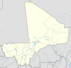
 Diangounté Camara
Coordinates: 14°32′42″N 9°30′47″W / 14.545°N 9.513°WCoordinates: 14°32′42″N 9°30′47″W / 14.545°N 9.513°W Country  Mali
MaliRegion Kayes Region Cercle Diéma Cercle Area[1] – Total 911 km2 (351.7 sq mi) Population (2009 census)[2] – Total 28,213 – Density 31/km2 (80.2/sq mi) Time zone GMT (UTC+0) Diangounté Camara is a rural commune and small town in the Cercle of Diéma in the Kayes Region of western Mali. The commune contains 13 villages and hamlets. In the 2009 census the commune had a population of 28,213.
References
- ^ (in French) Plan de Sécurite Alimentaire Commune Rurale de Diangounté Camara 2007-2011, Commissariat à la Sécurité Alimentaire, République du Mali, USAID-Mali, 2006, http://www.csa-mali.org/plans/Kayes/plansa_diema/psa_diangounte_camara.pdf.
- ^ (in French) Resultats Provisoires RGPH 2009 (Région de Kayes), République de Mali: Institut National de la Statistique, http://instat.gov.ml/documentation/kayes.pdf.
 Communes and towns of the Kayes Region, MaliCapital: Kayes
Bafoulabé
Cercle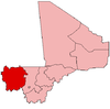
Diéma Cercle Diéma (Diéma) • Béma (Béma) • Diangounté Camara (Diangounté Camara) • Dianguirdé (Dianguirdé) • Diéoura (Diéoura) • Dioumara Koussata ( Dioumara Koussata) • Fassoudébé (Fassoudébé) • Fatao ( Fatao) • Gomitradougou ( Kouloudiengué) • Grouméra ( Grouméra) • Guédébiné (Guédébiné) • Lakamané (Lakamané) • Lambidou (Lambidou) • Madiga Sacko (Madiga Sacko) • Sansankidé ( Sansankidé)Kayes Cercle Kayes (Kayes) · Bangassi (Bangassi) · Diamou (Diamou) · Djelebou (Aourou) · Faleme (Diboli) · Fegui (Fegui) · Gory Gopela (Gory Gopela) · Goumera (Goumera) · Guidimakan Keri Kafo (Gakoura) · Hawa de Mbaya (Médine) · Kabate (Kabate) · Karakoro (Teichibe) · Kemene Tambo (Ambidedi) · Koniakary (Koniakary) · Kouloun (Kouloun) · Koussané (Koussané) · Liberte de Mbaya (Diabe Banlieue) · Logo (Kakoulou) · Marena Diombougou (Marena Diombougou) · Marintoumania (Marintoumania) · Sahel (Bafarara) · Samé Diomgoma (Samé) · Segala (Segala) · Sero Diamanou (Sero) · Somankidi (Somankidi) · Sadiola (Sadiola) · Sony (Lany Tounka) · Tafacirga (Tafacirga)Kéniéba Cercle Kita Cercle Kita (Kita) · Badia (Dafela) · Bendougouba (Bendougouba) · Benkadi Founia (Founia Moribougou) · Boudofo (Boudofo) · Bougaribaya (Bougaribaya) · Didenko (Didenko) · Djidian (Djidian) · Djoungoun (Djoungoun) · Gadougou I (Sagabari) · Gadougou II (Galle) · Guemoukouraba (Guemoukouraba) · Kassaro (Kassaro) · Kira Ouest (Kofeba) · Kita Nord (Sibikily) · Kobri (Kobri) · Kokofata (Kokofata) · Koulou (Balia) · Kourounikoto (Kourounikoto) · Kotouba (Kotouba) · Madina (Madina) · Makano (Makano) · Namala Guimba (Namala) · Niantanso (Niantanso) · Saboula (Balandougou) · Sebekoro (Sebekoro) · Sefeto Nord (Niagane) · Sefeto Ouest (Sefeto) · Senko (Senko) · Sirakoro (Sirakoro) · Souransan-Tomoto (Souransan-Tomoto) · Tambaga (Tambaga) · Toukoto (Toukoto)Nioro Cercle Nioro du Sahel (Nioro du Sahel) · Baniéré Koré (Baniéré Koré) · Diabigue (Diabigue) · Diarra (Diarra) · Diaye Coura (Diaye Coura) · Gavinane (Gavinane) · Gogui (Gogui) · Guétéma (Guétéma) · Kadiaba Kadiel (Kadiaba Kadiel) · Koréra Koré (Koréra Koré) · Nioro Tougouné Rangabé (Nioro Tougouné Rangabé ) · Sandare (Sandare) · Simbi (Simbi) · Trougoumbé (Trougoumbé) · Yéréré (Yéréré) · Youri (Youri)Yélimané Cercle Guidimé (Yélimané) · Diafounou Dionaga (Dionaga) · Diafounou Gory (Tambacara) · Fanga (Fanga) · Gory (Gory) · Kirane Kaniaga (Kirane) · Konsiga (Kersiniane) · Kremis (Kremis) · Marenkaffo (Dogofiry) · Soumpou (Takaba) · Tringa (Marena) · Toya (Yaguine)Categories:- Populated places in the Kayes Region
- Communes of Mali
- Kayes Region geography stubs


Wikimedia Foundation. 2010.