- Kayes Region
Demographic info|name=Kayes Region
capital=Kayes
population=1,506,299
census=2001
area=120,760
density=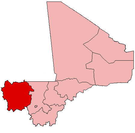
Kayes Region is one of eight first level national subdivisions, called Regions in
Mali . It is the first administrative area of Mali and covers an area of 120,760 km². Its capital is the town ofKayes .Geography
The region of Kayes is bordered to the north by
Mauritania , to the west bySenegal , to the south byGuinea and to the east by the region of Koulikoro.The region has a population of 1,506,299 inhabitants. Ethnic groups of the area include
Soninké s,Khassonké s,Malinké s, and Peuls.Several rivers cross the region: the Baoulé, the Bafing, and the Bakoy which join at the town of
Bafoulabé to form theSénégal River . The Falls of Félou (4 km of Kayes), the Falls of Gouina (100 km to the south-east of Kayes on the Sénégal River),Lake Magui andLake Doro are located in the region.At the Guinean border, the climate is rather wet, but becomes Sudanian and later
Sahel ian to the north.The large cities in the region are
Kayes ,Nioro du Sahel ,Dièma ,Yélimané ,Sadiola ,Bafoulabé ,Kénébia and Kita.The
National park of Bafing and theBoucle du Baoulé National Park are located in the region.Cercles
Kayes is divided into 7 cercles:
*Bafoulabe
*Diema
*Kita
*Kenieba
*Kayes
*Nioro
*Yelimane History
The region of Kayes is the cradle of the Kingdom of Khasso founded at the beginning of the 19th century.
In 1855,
Louis Faidherbe , Governor of Senegal, built a fort at Medina which would be besieged by El Hadj Omar Tall, in an 1857 war against the sovereign of Khasso. In 1892, the town ofKayes became the capital ofFrench Sudan .The construction of the
railway line of Dakar-Niger , inaugurated in 1904, made of Kayes a city-crossroads. Essential at the time, the railroad had an important place in the lives of the inhabitants, as described inOusmane Sembène 's novel "God's Bits of Wood".ee also
*
Regions of Mali
*Cercles of Mali
Wikimedia Foundation. 2010.