- Knightsen, California
Infobox Settlement
official_name = Knightsen, California
settlement_type = CDP
imagesize =
image_caption =
image_
imagesize =
image_caption =
image_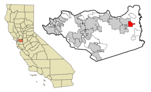
mapsize = 250x200px
map_caption = Location in Contra Costa County and the state ofCalifornia
mapsize1 =
map_caption1 =
subdivision_type = Country
subdivision_type1 = State
subdivision_type2 = County
subdivision_name =United States
subdivision_name1 =California
subdivision_name2 = Contra Costa
government_type =
leader_title = N/A
leader_name =
leader_title1 = Senate
leader_name1 =Tom Torlakson (D)
leader_title2 = Assembly
leader_name2 = Guy Houston (R)
leader_title3 = U. S. Congress
leader_name3 =Ellen Tauscher (D)
established_date =
area_magnitude =
area_total_km2 = 13
area_total_sq_mi = 5
area_land_km2 = 13
area_land_sq_mi = 5
area_water_km2 = 0
area_water_sq_mi = 0
elevation_ft = 30
elevation_m = 9
population_as_of = 2000
population_footnotes =
population_total = 861
population_metro =
population_density_km2 = 66.2
population_density_sq_mi = 172.2
timezone = PST
utc_offset = -8
latd = 37 |latm = 58 |lats = 9 |latNS = N
longd = 121 |longm = 39 |longs = 56 |longEW = W
timezone_DST = PDT
utc_offset_DST = -7
postal_code_type =ZIP code
postal_code = 94548
area_code = 925
blank_name = FIPS code
blank_info = 06-38772
blank1_name = GNIS feature ID
blank1_info = 1658916
footnotes =
website =Knightsen is a
census-designated place (CDP) in Contra Costa County,California , in theUnited States . As of the 2000 census, the CDP population was 861.Geography
According to the
United States Census Bureau , the CDP has a total area of 5.0square mile s (13.0km² ), all of it land.Demographics
As of the
census GR|2 of 2000, there were 861 people, 281 households, and 214 families residing in the CDP. Thepopulation density was 171.7 people per square mile (66.4/km²). There were 289 housing units at an average density of 57.6/sq mi (22.3/km²). The racial makeup of the CDP was 75.96% White, 0.12% Black or African American, 1.39% Native American, 0.23% Asian, 0.70% Pacific Islander, 12.54% from other races, and 9.06% from two or more races. 26.48% of the population were Hispanic or Latino of any race.There were 281 households out of which 32.4% had children under the age of 18 living with them, 63.7% were married couples living together, 7.1% had a female householder with no husband present, and 23.8% were non-families. 17.1% of all households were made up of individuals and 8.9% had someone living alone who was 65 years of age or older. The average household size was 3.04 and the average family size was 3.42.
In the CDP the population was spread out with 27.4% under the age of 18, 7.1% from 18 to 24, 27.3% from 25 to 44, 26.6% from 45 to 64, and 11.6% who were 65 years of age or older. The median age was 39 years. For every 100 females there were 97.9 males. For every 100 females age 18 and over, there were 101.6 males.
The median income for a household in the CDP was $58,929, and the median income for a family was $64,643. Males had a median income of $48,500 versus $32,708 for females. The
per capita income for the CDP was $22,191. About 7.3% of families and 8.7% of the population were below thepoverty line , including 5.3% of those under age 18 and 19.8% of those age 65 or over.History
Knightsen, California is a small unincorporated community of 1,200 residents and 1,500 horses in far eastern
Contra Costa County, California in the easternSan Francisco Bay Area closest toOakley, California .Eye on the Bay, CBS5, September 21, 2008] The town was founded by George W. Knight. The town's name is a portmanteau of his last name and his wife Christina Christensen. Knightsten has the oldest chapter of the 4H club in California. The community is worried about urban sprawl from the expanding tract housing from neighboring Oakley.Knightsen was founded in 1898 when it became a stop for the Atchinson Topeka and Santa Fe railroad. Knightsen's founder was George Knight. He was married to a woman by the last name of Christensen thus the two names were combined to become Knightsen. Knightsen has primarily been a farming community, growing such foods as almonds, walnuts, sunflower seeds, etc. It still contains a few U-pick vegetable/fruit stands. Knightsen now is home to many horse ranches.
References
External links
Wikimedia Foundation. 2010.