- Meridian Hill Park
-
Meridian Hill Park
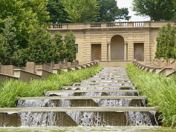 A thirteen-basin cascade fountain is one of the most dramatic features of Meridian Hill Park
Location: Bounded by 16th, Euclid, 15th, and W Sts., NW.
Washington, D.C.Architect: George Burnap NRHP Reference#: 74000273 Significant dates Added to NRHP: October 25, 1974 Designated NHL: April 19, 1994[1] Meridian Hill Park, is located in the Washington, D.C. neighborhood of Columbia Heights in the United States. The 12 acres (49,000 m²) of landscaped grounds are maintained by the National Park Service as part of Rock Creek Park, but are not contiguous with the main part of that park. Meridian Hill Park is bordered by 15th, 16th, W, and Euclid Streets NW.
Contents
History
In 1819, John Porter erected a mansion on the grounds and called it "Meridian Hill" because it was located on the "White House meridian" (see Washington meridian). During the 19th century the environs of Meridian Hill became host to Columbian College (1821), later renamed George Washington University. Columbia Road was named for the college, and formed the northern boundary of the original campus. Prior to the Civil War, the mansion grounds became a pleasure park for the area. During the war, Union troops encamped there in Camp Cameron "on Georgetown Heights".[2][3][4] In 1883, the writer Joaquin Miller built a cabin in Meridian Hill Park. The cabin is now located in Rock Creek Park.[5]
Much of the impetus for creating a public park on this portion of 16th Street came from Mary Foote Henderson, wife of Missouri senator John Brooks Henderson and local resident. She lobbied Congress with several plans for the neighborhood before getting approval for the park, including supporting a plan by architect Franklin W. Smith to construct a colossal presidential mansion on Meridian Hill to replace the White House.
The land was originally part of the Columbian College grounds. In 1910, after the school moved to its current location in Foggy Bottom, the federal government bought the land, and in 1914 the Interior Department hired landscape architect George Burnap to design a grand urban park modeled on parks found in European capitals. His plans, later modified by Horace Peaslee, included an Italian Renaissance-style terraced fountain in the lower half and gardens in a French Baroque style in the upper half. The walls and fountains were built with concrete aggregate, a new building material consisting of concrete mixed with small pebbles. After two decades under construction, the grounds were given park status in 1936 and have been designated a National Historic Landmark.
In the 1970s and 80s, crime became widespread in the surrounding neighborhoods. Meridian Hill Park became a haven for drug dealing and was considered unsafe, especially at night. After the murder of a local teenager near the park in 1990, a group of citizens formed "Friends of Meridian Hill Park". They organized volunteer nighttime patrols and lobbied the National Park Service to make improvements to the park.
On Sunday afternoons during the warm weather months, people gather from 3–9:00 p.m. in the upper park to dance and participate in a drum circle. The activity has been held in the park since the 1950s, and attracts professional drummers from time to time.[6][7]
It was designated a National Historic Landmark in 1994.[1]
Statues and features
 Joan of Arc statue
A central feature of the park is the thirteen basin Cascading Waterfall in the lower-level formal garden. The fountains are designed with a recirculating water system which, through an elaborate series of pumps, supplies water to two large circular fountains on the upper level, and cascade found on the lower.
Statues
- Serenity by sculptor Jose Clara, dedicated to the memory of Lt. Commander William Henry Scheutze (USN);
- Joan of Arc, a gift from the "Ladies of France in Exile in New York" in 1922.[8] It is a bronze copy of a 1889 statue by Paul Dubois. The original is at the Reims Cathedral in France. In a city of many equestrian statues, this is the only one to depict a woman.
- Dante by Ettore Ximenes;
- James Buchanan Memorial, the 15th president of the United States, sculpted by Hans Schuler.
References
- ^ a b "Meridian Hill Park". National Historic Landmark summary listing. National Park Service. http://tps.cr.nps.gov/nhl/detail.cfm?ResourceId=1411&ResourceType=District. Retrieved 2009-08-21.
- ^ The Blue and Gray in Black and White by Bob Zeller (Praeger Publishers 2005) p. 50.
- ^ "''Harper's Weekly'' illustrations". Sonofthesouth.net. 2007-01-26. http://www.sonofthesouth.net/leefoundation/civil-war/1861/may/camp-cameron-georgetown.htm. Retrieved 2009-07-16.
- ^ "''Harper's Weekly'' brief report". Sonofthesouth.net. 2007-01-26. http://www.sonofthesouth.net/leefoundation/civil-war/1861/may/winans-steam-gun.htm. Retrieved 2009-07-16.
- ^ http://www.nps.gov/mehi/historyculture/places.htm National Park Service - Meridian Hill Park Points of Interest - North to South
- ^ "Meridian Hill Park: Sports and Recreation Locations in Washington, DC on washingtonpost.com's City Guide". Washingtonpost.com. http://www.washingtonpost.com/ac2/wp-dyn?node=cityguide/profile&id=799601. Retrieved 2009-07-16.
- ^ "Meridian Hill/Malcolm X Park sur Flickr : partage de photos !". Flickr.com. 2006-04-23. http://www.flickr.com/photos/listenmissy/133454850/. Retrieved 2009-07-16.
- ^ ""A New Memorial to Jeanne d'Arc in Washington," Art and Archaeology, vol. 13 (Jan.-June 1922), p. 96". Books.google.com. 2008-01-31. http://books.google.com/books?id=iscUAAAAYAAJ&printsec=titlepage&source=gbs_v2_summary_r&cad=0. Retrieved 2009-07-16.
External links
- National Park Service
- Meridian Hill Park, NRHP 'travel itinerary' listing at the National Park Service
- Meridian Hill Park, Bounded by Fifteenth, Sixteenth, Euclid & W Streets, Northwest, Washington, District of Columbia, DC: 5 color and 51 b&w photos, 25 drawings, 69 data pages and supplemental material, at Historic American Building Survey
- Washington Parks and People
- Washington Post Entertainment Guide
- Meridian Hill Neighborhood Association
- NPR: Why Urban Joes and CEOs Bang the Drum
- The Wild Man At The Center Of The World
Coordinates: 38°55′16″N 77°02′08″W / 38.921236°N 77.035611°W
Categories:- National Historic Landmarks in Washington, D.C.
- United States National Park Service areas in Washington, D.C.
- Parks in Washington, D.C.
- Classical Revival architecture in Washington, D.C.


Wikimedia Foundation. 2010.