- Moonta Bay, South Australia
-
Moonta Bay
South Australia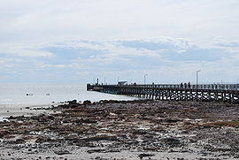
Jetty
 Moonta Bay
Population: 2,042 (2006 Census)[1] Postcode: 5558 Coordinates: 34°03′S 137°34′E / 34.05°S 137.567°ECoordinates: 34°03′S 137°34′E / 34.05°S 137.567°E LGA: District Council of the Copper Coast State District: Goyder Federal Division: Grey Moonta Bay is located in the Copper Coast region of Northern Yorke Peninsula South Australia, adjacent to the historic town of Moonta and Port Hughes. At the 2006 census, Moonta Bay had a population of 2,042.[1]
It is a popular tourist destination, with attractions including the beach and jetty.
Accommodation is available for tourists at the beachside caravan park and motel. There are a range of restaurants, cafes and a functions venue.
Notes and references
- ^ a b Australian Bureau of Statistics (25 October 2007). "Moonta Bay (State Suburb)". 2006 Census QuickStats. http://www.censusdata.abs.gov.au/ABSNavigation/prenav/LocationSearch?collection=Census&period=2006&areacode=SSC44231&producttype=QuickStats&breadcrumb=PL&action=401. Retrieved 11 October 2011.
External links
Towns and localities of the District Council of the Copper Coast Boors Plain · Cross Roads · Cunliffe · East Moonta · Hamley · Jericho · Jerusalem · Kadina · Kooroona · Matta Flat · Moonta · Moonta Bay · Moonta Mines · Newtown · North Beach · North Moonta · North Yelta · Paramatta · Paskeville · Port Hughes · Thrington · Tickera · Wallaroo · Wallaroo Mines · Wallaroo Plain · Warburto · Willamulka · YeltaYorke Peninsula, South Australia Major Townships Ardrossan · Bute · Kadina · Maitland · Minlaton · Moonta · Paskeville · Port Broughton · Wallaroo · YorketownCouncils Islands Goose Island · Wardang IslandCategories:- Towns in South Australia
- Yorke Peninsula
- Visitor attractions in South Australia
- Coastal towns in South Australia
- Bays of South Australia
- Beaches of South Australia


Wikimedia Foundation. 2010.