- Cilymaenllwyd
-
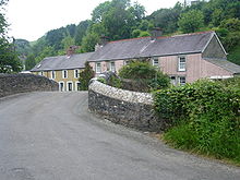 The hamlet of Login. Note the narrowness of the valley
Cilymaenllwyd is a community on the extreme northwest of Carmarthenshire in West Wales. It lies about 40 km west of Carmarthen, 20 km southeast of Fishguard and 30 km northwest of Haverfordwest.
Contents
History & Amenities
Cilymaenllwyd has an area of 2628 hectares and a population of 725.[1] The western edge of the community borders Pembrokeshire.[2] The Pembrokeshire River Tâf forms the eastern boundary. The area is a plateau being part of the foothills of the Preseli Mountains rising to an altitude of 248 metres. But it is dissected by deep valleys of the Tâf and tributaries. The principal commerce of the parish is agriculture. On 13 May 1839, the tollgate at Efailwen, within Cilymaenllwyd, was the first turnpike to be attacked in what would later become the Rebecca Riots, an uprising by poor farmers to abolish what they believed were unfair taxations.[3]
Historically it was part of Derllys Hundred.[4][5] Very few maps mark the name Cilymaenllwyd but place names which do appear are:
grid ref SN134253 Efailwen SN143266 Glandy Cross SN166234 Login SN149262 Pant-y-Caws Worship
Places of worship in the community are:
grid ref Erected SN153233 ? Parish church, now used as a clothing factory[6] SN165233 1828 Calfaria Particular Baptist Chapel, Login SN139257 1836 Nebo Independent Chapel, Efailwen / Eglwyswen SN162223 1858 Cwm-miles Independent Chapel, Cwm-miles Login
The hamlet of Login lies in the valley and sits on both sides of the River Tâf. The name Login may have come from the old Welsh language word halogyn meaning a dirty pool or stream.[7] The Whitland & Cardigan Railway came up the valley and there was a station in Login.[8]
References
- ^ Carmarthenshire County Council website
- ^ Following the transfer of Llandissilio West to Pembrokeshire on 1 April 2003 [1].
- ^ Davies, John; Jenkins, Nigel (2008). The Welsh Academy Encyclopaedia of Wales. Cardiff: University of Wales Press. p. 730. ISBN 978-0-7083-1953-6.
- ^ Map of Derllys Hundred
- ^ GenUKI page with historical information
- ^ Page at rootsweb
- ^ Origin of Login name
- ^ http://www.subbrit.org.uk/sb-sites/stations/l/login/index.shtml Login Station at Subrerranea Britannica
Preceding station Historical railways Following station Whitland
via LlanfaltegGreat Western Railway
Whitland & Cardigan RailwayRhydowen
via LlanglydwenCategories:- Communities of Carmarthenshire
- Carmarthenshire geography stubs

Wikimedia Foundation. 2010.