- Brewton, Alabama
:"See also
East Brewton, Alabama "Infobox Settlement
official_name = Brewton, Alabama
settlement_type =City
imagesize =
image_caption =
image_
imagesize =
image_caption =
image_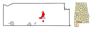
mapsize = 250px
map_caption = Location in Escambia County and the state ofAlabama
mapsize1 =
map_caption1 =
subdivision_type = Country
subdivision_type1 = State
subdivision_type2 = County
subdivision_name =United States
subdivision_name1 =Alabama
subdivision_name2 = Escambia
government_type =
leader_title =
leader_name =
established_date =
area_magnitude =
area_total_km2 = 29.7
area_total_sq_mi = 11.4
area_land_km2 = 29.3
area_land_sq_mi = 11.3
area_water_km2 = 0.4
area_water_sq_mi = 0.1
elevation_ft = 82
elevation_m = 25
population_as_of = 2000
population_footnotes =
population_total = 5498
population_metro =
population_density_km2 = 185.1
population_density_sq_mi = 482.3
timezone = Central (CST)
utc_offset = -6
latd = 31 |latm = 7 |lats = 3 |latNS = N
longd = 87 |longm = 4 |longs = 16 |longEW = W
timezone_DST = CDT
utc_offset_DST = -5
postal_code_type =ZIP code
postal_code = 36426-36427
area_code = 251
blank_name = FIPS code
blank_info = 01-09208
blank1_name = GNIS feature ID
blank1_info = 0157900
footnotes =
website =Brewton is a city in Escambia County,
Alabama ,United States . At the 2000 census the population was 5,498. The city is thecounty seat of Escambia County.Geography
Brewton is located at coor dms|31|7|4|N|87|4|16|W|city (31.117706, -87.071164)GR|1.
According to the
U.S. Census Bureau , the city has a total area of 11.5square mile s (29.7km² ), of which, 11.3 square miles (29.3 km²) of it is land and 0.1 square miles (0.4 km²) of it (1.22%) is water.Demographics
As of the
census GR|2 of 2000, there were 5,498 people, 2,216 households, and 1,471 families residing in the city. Thepopulation density was 485.2 people per square mile (187.4/km²). There were 2,543 housing units at an average density of 224.4/sq mi (86.7/km²). The racial makeup of the city was 57.60% White or Caucasian, 40.23% Black or African American, 0.42% Native American, 0.49% Asian, 0.53% from other races, and 0.73% from two or more races. 1.11% of the population were Hispanic or Latino of any race.There were 2,216 households out of which 27.5% had children under the age of 18 living with them, 46.3% were married couples living together, 17.1% had a female householder with no husband present, and 33.6% were non-families. 31.0% of all households were made up of individuals and 15.6% had someone living alone who was 65 years of age or older. The average household size was 2.35 and the average family size was 2.95.
In the city the population was spread out with 23.8% under the age of 18, 7.1% from 18 to 24, 24.1% from 25 to 44, 25.5% from 45 to 64, and 19.6% who were 65 years of age or older. The median age was 42 years. For every 100 females there were 85.2 males. For every 100 females age 18 and over, there were 79.1 males.
The median income for a household in the city was $34,234, and the median income for a family was $43,548. Males had a median income of $37,348 versus $20,212 for females. The
per capita income for the city was $18,185. About 12.6% of families and 16.3% of the population were below thepoverty line , including 25.3% of those under age 18 and 18.4% of those age 65 or over.City schools
*
Brewton Elementary School , part of the Brewton City School System, is located on Douglas Ave. inBrewton ,Alabama .
*Brewton Middle School , part of the Brewton City School System, is located on Liles Blvd. inBrewton ,Alabama .
*T.R. Miller High School , part of the Brewton City School System, is located on Douglas Ave. inBrewton ,Alabama .Higher education
Brewton is home to
Jefferson Davis Community College , a small postsecondary school that primarily awardsassociate's degree s.Culture and special events
The annual
Alabama Blueberry Festival is held atBurnt Corn Creek Park and downtown Brewton. Prior to 2006 it was held on the campus ofJefferson Davis Community College .References
External links
* [http://www.cityofbrewton.org City of Brewton] is the city's website.
* [http://www.brewtonstandard.com/ Brewton Standard] is the local newspaper.
* [http://www.escambiaida.com/brewton_statistics.htm Brewton statistics] from Escambia County Industrial Development Authority website
* [http://www.cgeda.net Coastal Gateway Regional Economic Development Authority]
Wikimedia Foundation. 2010.