- Fort Payne, Alabama
Infobox Settlement
official_name = Fort Payne, Alabama
settlement_type =City 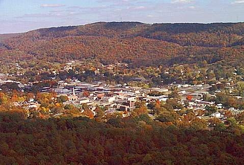
imagesize = 150
image_caption = Aerial view of Fort Payne, Alabama
(Lookout Mountain in background0
image_

mapsize = 250px
map_caption = Location in DeKalb County and the state ofAlabama
mapsize1 =
map_caption1 =
subdivision_type = Country
subdivision_type1 = State
subdivision_type2 = County
subdivision_name =United States
subdivision_name1 =Alabama
subdivision_name2 = DeKalb
government_type = Mayor-Council (5 members)
leader_title = Mayor
leader_name = [http://www.ag.auburn.edu/adm/alumni/activities/documents/JordanWA.pdf Bill Jordan] (term ends 2012)
established_date = 1889
area_magnitude =
area_total_km2 = 144.9
area_total_sq_mi = 56
area_land_km2 = 144.7
area_land_sq_mi = 55.9
area_water_km2 = 0.2
area_water_sq_mi = 0.1
elevation_ft = 906
elevation_m = 276
population_as_of = 2000
population_footnotes =
population_total = 12938
population_metro =
population_density_km2 = 89.3
population_density_sq_mi = 231
timezone = Central (CST)
utc_offset = -6
latd = 34 |latm = 27 |lats = 13 |latNS = N
longd = 85 |longm = 42 |longs = 23 |longEW = W
timezone_DST = CDT
utc_offset_DST = -5
postal_code_type =ZIP code
postal_code = 35967-35968
area_code = 256
blank_name = FIPS code
blank_info = 01-27616
blank1_name = GNIS feature ID
blank1_info = 0150235
footnotes =
website =Fort Payne is a city in DeKalb County,
Alabama ,United States . At the 2000 census the population was 12,938. The city is thecounty seat of DeKalb County. It bills itself as the "OfficialSock Capital of the World."For a time beginning in 1989, Fort Payne held the world record for "Largest Cake Ever Baked," for a cake of 128,238 pounds (58,290 kg) baked to commemorate the city's centennial. ["Biggest and Most and Devoured in the U.S.A.," "The New York Times", July 3, 1991]
A magnitude 4.9 earthquake occurred here in 2003. [ [ftp://hazards.cr.usgs.gov/maps/sigeqs/20030429/20030429.pdf U.S. Geological Survey: Fort Payne, Alabama Earthquake of 29 April 2003] ]
History
The site of Fort Payne was originally the important
Cherokee village ofWillstown , which for a time was the home of the famous CherokeeSequoyah , who invented the Cherokeealphabet . During theIndian removal (orTrail of Tears ) during the 1830s a fort was built in the town by forces commanded by Major John Payne and used as a stockade in which to place the Cherokee until they could be removed toOklahoma . The settlement was commonly called Willstown, after its headman, a red-headed mixed-race man named Will, but that was not its real name. According to Major John Norton, son of a Cherokee adoptee of the Mohawk, who travelled extensively throughout the region in the early 19th century and stayed there several times, the actual name of the town would transliterate as "Titsohili". [ [http://www.tourdekalb.com/history.shtml DeKalb County Tourist Association: History of DeKalb County] ]Perhaps because Fort Payne and the surrounding area were sparsely settled in the 1860's, and contained no strategic targets, the area was only the scene of minor skirmishes between Union and Confederate forces during the Civil War. Around the time of the
Second Battle of Chattanooga , a large Union force briefly entered the county, but it did not engage substantial Confederate forces. [ [http://www.landmarksdekalbal.org/articles/CivilWarSkirmishes.html Landmarks of DeKalb County: Civil War Skirmishes] ] [ [http://www.landmarksdekalbal.org/history/DeKalbHistory.html Landmarks of DeKalb: History of DeKalb County] ]Fort Payne became the county seat in 1878, before it was incorporated in 1889. The community of Lebanon had previously served as the county seat since 1850. However, the completion of the rail lines between Birmingham and Chattanooga had caused Fort Payne to grow, and there was sentiment that the county seat should be in a community served by the railroad, which Lebanon was not. [ [http://www.landmarksdekalbal.org/history/DeKalbHistory.html Landmarks of DeKalb: History of DeKalb County] ]
Fort Payne experienced explosive growth in the late 1880s, as investors from New England and elsewhere flooded into the region to take advantage of coal and iron deposits that had been discovered a few years earlier. The period is today known as the "Boom Days," or simply as the "Boom." Many of the notable and historic buildings in Fort Payne today date from this period, including the state's oldest standing theatre, the [http://www.landmarksdekalbal.org/articles/OperaHouse.html Fort Payne Opera House] ; the former factory of the Hardware Manufacturing Company (today known as the W.B. Davis Mill Building, and home to an [http://www.mjsgrillatthemill.com/ antiques mall and deli] ), and the [http://www.fortpaynedepotmuseum.org/ Fort Payne Depot Museum] , formerly the passenger station for what is today the
Norfolk Southern Railway , and which serves today as a museum for local history. [ [http://www.tourdekalb.com/history.shtml DeKalb County Tourist Association: History of DeKalb County] ]When the iron and coal deposits on which the Boom was based turned out to be much smaller than expected, many of the Boom promoters returned to New England, and Fort Payne experienced a period of economic decline. That downturn came to an end beginning in 1907, when the W.B. Davis Hosiery Mill began operations, marking the beginning of Fort Payne's long running identification with the hosiery industry. [ [http://www.landmarksdekalbal.org/communities/FortPayne4.html Landmarks of DeKalb Communities: Fort Payne] ] By the beginning of the 21st Century, the hosiery industry in Fort Payne employed over 7,000 people in over 100 mills, and accounted for the manufacture of over half the socks made in the United States. Beginning in the 1990's, the ratification of international trade agreements such as the
North American Free Trade Agreement and theCentral American Free Trade Agreement loweredtariffs on textile products imported into the United States, resulting in large increases in sock imports. Many in Fort Payne accused foreign manufacturers, particularly those fromChina , of engaging in dumping of socks below cost, to force American companies out of the sock business. By 2005, hosiery mill employment in Fort Payne had declined to around 5,500, and several mills had closed. The federal government responded in late 2005 by reaching an agreement with the Chinese government to slow the schedule for the removal of tariffs, delaying their full removal until 2008. [ [http://www.gadsdentimes.com/article/20051109/NEWS/511090350 "Government Acts to Help Textile Mills," "The Gadsden Times", November 9, 2005, p. B1] ] ["'Sock Capital of the World' Fights Back," "The Huntsville Times", September 1, 2004, p. B2]Unlike at the end of the Boom, Fort Payne began in the 1990's to take steps to diversify its economy. These efforts resulted in the development of several new commercial and industrial projects, the largest of which was the 2006 construction of a distribution center for [http://www.childrensplace.com/webapp/wcs/stores/servlet/Home?storeId=10001&langId=-1&catalogId=10001 The Children's Place] stores, a facility that will employ 600 people in its first phase of operation. [ [http://www.gadsdentimes.com/article/20060927/NEWS/609270333 New Retail Distribution Center in DeKalb Will Employ up to 600 Workers," "The Gadsden Times", September 27, 2006, p. A1] ]
Local Attractions
Fort Payne is the home of the
Little River Canyon National Preserve , a 14,000 acre (57 km²)National Park Service facility established by Congress in 1992. Although the canyon, atopLookout Mountain , is outside the city limits, the preserve headquarters is located in Fort Payne. Adjacent to the Preserve and the Fort Payne city limits is DeSoto State Park, a smaller facility with a lodge, restaurant, cabins, and river access areas.Fort Payne is the hometown of the country music group Alabama. It is also home of the group's [http://www.thealabamaband.com/fanclub.html Fan Club and Museum] .
Although Fort Payne's location between Lookout Mountain and
Sand Mountain leaves it served by only a small stream, Wills Creek, the city is within a 30 minute drive of substantial water recreational areas, notablyGuntersville Lake , and Lake Weiss, an artificial lake on theCoosa River . Fort Payne is also near Mentone, a popular mountain resort area known for summer children's camps and rustic hotels, restaurants and cabins.Near Fort Payne is [http://www.akinsfurniture.com/aboutus.htm Akins Furniture] , a business centered in an old country store building which bills itself as the largest furniture store in Alabama. ["Furniture Warehouse, Store to Boost Job Force," "The Birmingham News", January 11, 2006, p. 2C]
Geography
Fort Payne is located at coor dms|34|27|14|N|85|42|24|W|city (34.453829, -85.706648)GR|1.
According to the
U.S. Census Bureau , the city has a total area of 56.0square mile s (144.9km² ), of which, 55.9 square miles (144.7 km²) of it is land and 0.1 square miles (0.2 km²) of it (0.14%) is water.The town lies in a narrow valley in the Cumberland Plateau region immediately west of
Lookout Mountain , withSand Mountain somewhat more removed to the west. Drainage is through Big Wills Creek to theCoosa River .Elevation: 899 feet
Climate
Fort Payne is notable for a temperate, subtropical climate. Winters usually feature measurable, though infrequent, snow. The [http://www.cloudmont.com/ Cloudmont Ski Resort] , nearby on Lookout Mountain, makes manmade snow as winter temperatures permit. The area is subject to occasional tornadoes. In the
Palm Sunday tornado outbreak of 1994 , an F3 tornado passed just west of the city, and the city itself was hit by tornadoes in 1973 and 1982. ["DeKalb Assessing Tornado Damage," "The Huntsville Times", March 29, 1994, p. B1] Occasionally, a hurricane that has made landfall in the Gulf of Mexico will reach Fort Payne as a tropical storm or tropical depression. However, in 1995 the eye ofHurricane Opal reached Fort Payne with hurricane-force winds. ["Area Escapes Storm's Worst," "The Huntsville Times", October 5, 1995, p. A1] Even more freakish was the famous 1993 Storm of the Century, which hit Fort Payne with over 20 inches of snow, immobilizing the city and the surrounding area for days.[http://www.Weatherbase.com source: weatherbase.com]
Demographics
As of the
census GR|2 of 2000, there were 12,938 people, 5,046 households, and 3,506 families residing in the city. Thepopulation density was 231.5 people per square mile (89.4/km²). There were 5,585 housing units at an average density of 100.0/sq mi (38.6/km²). The racial makeup of the city was 83.22% White, 4.53% Black or African American, 0.80% Native American, 0.55% Asian, 0.16% Pacific Islander, 8.41% from other races, and 2.33% from two or more races. 12.17% of the population were Hispanic or Latino of any race.There were 5,046 households out of which 31.2% had children under the age of 18 living with them, 53.9% were married couples living together, 11.6% had a female householder with no husband present, and 30.5% were non-families. 26.9% of all households were made up of individuals and 12.1% had someone living alone who was 65 years of age or older. The average household size was 2.49 and the average family size was 2.97.
In the city the population was spread out with 23.4% under the age of 18, 10.2% from 18 to 24, 29.3% from 25 to 44, 21.6% from 45 to 64, and 15.6% who were 65 years of age or older. The median age was 36 years. For every 100 females there were 92.3 males. For every 100 females age 18 and over, there were 88.5 males.
The median income for a household in the city was $33,560, and the median income for a family was $40,200. Males had a median income of $29,731 versus $20,135 for females. The
per capita income for the city was $19,690. About 8.3% of families and 12.3% of the population were below thepoverty line , including 15.0% of those under age 18 and 17.6% of those age 65 or over.Education
Fort Payne is served by the [http://www.ftpayk12.org/ Fort Payne City Schools system] , which includes:
*Wills Valley Elementary (K-2)
*Williams Avenue Elementary (3-4)
*Fort Payne Middle School (5-8)
*Fort Payne High School (9-12), home of the WildcatsHealth Care
* [http://www.dekalbregional.com/default.aspx DeKalb Regional Medical Center] 134 bed facility
Media
*Radio: WFPA-AM 1400
*Radio: WZOB-AM 1250
*Newspaper: " [http://times-journal.com/index.lasso? The Times Journal] "Transportation
*
*
*
*
* (municipal airport)Notable people from Fort Payne
*
Miles C. Allgood , Congressman, State Auditor
*Jeff Cook, guitarist, country music group Alabama
*Lt. Gen.Duward Crow , Assistant Vice Chief of Staff, USAF and Associate Deputy Administrator, NASA
*Howard Finster , famous religious folk artist and Baptist minister
*Flock Family (NASCAR drivers):*Bob Flock :*Fonty Flock :*Tim Flock :*Ethel Mobley
*Teddy Gentry, bass, country music group Alabama
*Milford W. Howard , Congressman, author and silent film producer and actor
*Lt. Gen.Forrest S. McCartney , USAF, commander,John F. Kennedy Space Center
*Larry Nelson , professional golfer
*Philip Ober , actor
*Randy Owen , lead singer, country music group Alabama
*Lilius Bratton Rainey , Congressman
*Ron Sparks, Alabama Commissioner of Agriculture and Industries
*Katherine Stinson , pioneer aviatrix, fourth woman in the U.S. to become a licensed pilotReferences
External links
* [http://www.fortpayne.org FortPayne.org]
* [http://www.FortPayne.info FortPayne Information Site] - Includes: Weather, Driving directions, Maps, Tourist information, Place information, Pictures And much more ...
* [http://www.landmarksdekalbal.org/ Landmarks of DeKalb County, Alabama]
Wikimedia Foundation. 2010.