- Mira Mar, Western Australia
-
Mira Mar
Albany, Western Australia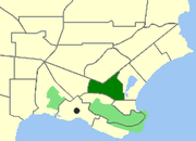
Location of Mira Mar within AlbanyPopulation: 1,696 (2006 Census) Postcode: 6330 Elevation: 36 m (118 ft) Area: 1.7 km² (0.7 sq mi) Location: 2 km (1 mi) from Albany LGA: City of Albany State District: Albany Federal Division: O'Connor Suburbs around Mira Mar: Spencer Park Spencer Park Seppings Centennial Park Mira Mar Seppings Mount Clarence Mount Clarence Middleton Beach Coordinates: 35°01′01″S 117°54′00″E / 35.017°S 117.9°E
Mira Mar is a northeastern suburb of Albany, Western Australia, between the Albany city centre and Spencer Park. Its Local Government Area is the City of Albany.
Mira Mar was gazetted as a suburb in 1979.[1]
Geography
Mira Mar is bounded by North and Collingwood Roads to the north, Drew Street to the east, Symers Street to the west and Middleton Road to the south.[2] The suburb has a population of 1,539 persons.[3] Strawberry Hill (62 m) and Craggy Bluff dominate the local landscape.
Facilities
Mira Mar contains the Old Farm at Strawberry Hill, which was first a 9.7-hectare (24-acre) vegetable farm on Plantagenet Location 44 for the military settlement of King George Sound, and then served as the residence of Albany's first Government Resident, Sir Richard Spencer RN, from 1832 until 1839. Spencer's grave is located on the site.[4] Also in Mira Mar is the simple Victorian Georgian house built in 1872 by Matthew Cull, who was the long-time verger at St John's Church in Albany.[5] Cull Park, in the suburb's northwest on Campbell Road, is 1.1 hectares (3 acres) in size and contains a small bridged pond and play equipment.[6]
References
- ^ "Naming of Localities - Town of Albany (per 3773/57 V4)". Western Australia Government Gazette: p. 1979:1501. 8 June 1979.
- ^ Department of Land Information. StreetSmart® Perth Street Directory (50 (2009) ed.). West Australian Newspapers Ltd. pp. Map A2, A5. ISBN 978-1-921048-28-9.
- ^ Australian Bureau of Statistics (25 October 2007). "Mira Mar (State Suburb)". 2006 Census QuickStats. http://www.censusdata.abs.gov.au/ABSNavigation/prenav/LocationSearch?collection=Census&period=2006&areacode=SSC54781&producttype=QuickStats&breadcrumb=PL&action=401. Retrieved 2008-10-02. See CCDs 5052002, 5052003, 5052009 for 2001 comparisons.
- ^ Heritage Council of Western Australia (14 December 2001). "Register of Heritage Places - Hawthorndene". http://register.heritage.wa.gov.au/PDF_Files/H%20-%20A-D/Hawthorndene%20(I-AD).PDF. Retrieved 2007-06-03.
- ^ Heritage Council of Western Australia (4 August 1998). "Register of Heritage Places - Matthew Cull's House". http://register.heritage.wa.gov.au/PDF_Files/M%20-%20A-D/Matthew%20Culls%20House%20(I-AD).PDF. Retrieved 2007-06-03.
- ^ City of Albany (7 May 2007). "Cull Park". http://www.albany.wa.gov.au/website/page.php?folder=14a&page=parks&park_id=5. Retrieved 2007-06-03.
Localities in the Albany region | Great Southern | Western Australia Suburbs: Albany · Bayonet Head · Centennial Park · Collingwood Heights · Collingwood Park · Emu Point · Gledhow · Lange · Lockyer · McKail · Middleton Beach · Milpara · Mira Mar · Mount Clarence · Mount Elphinstone · Mount Melville · Orana · Port Albany · Robinson · Seppings · Spencer Park · Walmsley · Warrenup · Willyung · Yakamia
Regional: Big Grove · Elleker · Frenchman Bay · Goode Beach · Kalgan · King River · Little Grove · Lower King · Torbay · Torndirrup · Vancouver Peninsula
Categories:- Suburbs of Albany, Western Australia
- Western Australia geography stubs

Wikimedia Foundation. 2010.