- Orana, Western Australia
-
Orana
Albany, Western Australia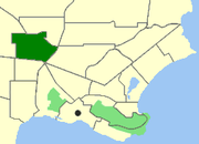
Map of Orana within Albany.Population: 1,994 (2006 Census) [1] Postcode: 6330 Location: 3.2 km (2 mi) from Albany LGA: City of Albany State District: Albany Federal Division: O'Connor Suburbs around Orana: McKail Milpara Milpara McKail Orana Yakamia Gledhow Lockyer Centennial Park Coordinates: 34°59′53″S 117°51′47″E / 34.9981°S 117.863°E
Orana is a north-western suburb of Albany in southern Western Australia, located north west of Albany's central business district. Its Local Government Area is the City of Albany. The suburb has a median age of 33.
Geography
The suburb is bounded to the North by Anson Road, to the South and East by South Coast Highway and to the West by Le Grand Avenue. Albany Highway passes through the middle of the suburb.
References
- ^ Australian Bureau of Statistics (25 October 2007). "Orana (Urban Centre/Locality)". 2006 Census QuickStats. http://www.censusdata.abs.gov.au/ABSNavigation/prenav/LocationSearch?collection=Census&period=2006&areacode=SSC55181&producttype=QuickStats&breadcrumb=PL&action=401. Retrieved 2010-02-23.
Localities in the Albany region | Great Southern | Western Australia Suburbs: Albany · Bayonet Head · Centennial Park · Collingwood Heights · Collingwood Park · Emu Point · Gledhow · Lange · Lockyer · McKail · Middleton Beach · Milpara · Mira Mar · Mount Clarence · Mount Elphinstone · Mount Melville · Orana · Port Albany · Robinson · Seppings · Spencer Park · Walmsley · Warrenup · Willyung · Yakamia
Regional: Big Grove · Elleker · Frenchman Bay · Goode Beach · Kalgan · King River · Little Grove · Lower King · Torbay · Torndirrup · Vancouver Peninsula
Categories:- Suburbs of Albany, Western Australia

Wikimedia Foundation. 2010.