Spencer Park, Western Australia
- Spencer Park, Western Australia
Infobox Australian Place | type = suburb
name = Spencer Park
city = Albany
state = wa
imagesize= 180
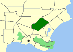
caption = Map of Spencer Park within Albany.
lga = City of Albany
postcode = 6330
pop = 3,313 (2006 census)
area = 2.3
stategov = Albany
fedgov = O'Connor
near-nw = Collingwood Heights
near-n = Collingwood Heights
near-ne = Collingwood Park
near-w = Yakamia
near-e = Seppings
near-sw = Centennial Park
near-s = Mira Mar
near-se = Mira Mar
dist1 = 2.5
location1= Albanycoord|-34.998|117.903|type:city(3313)_region:AU-WA_scale:50000|format=dms|display=title
Spencer Park is a north-eastern suburb of Albany in southern Western Australia, located north-northeast of Albany's central business district. Its Local Government Area is the City of Albany, and the suburb was first gazetted in 1954. [Gazette WA | title = Naming of Localities at Albany | file = 8175/50 | page = 1954:1494 | date = 27 August 1954]
Geography
The suburb, named after Albany's first Government Resident Sir Richard Spencer RN and gazetted in 1954, is bounded by Ulster Road to the west and north, Collingwood Road to the southeast and North Road to the south. [Streetsmart WA|maps=Map A2]
Facilities
Spencer Park contains a shopping centre, fuel station, primary school, a retirement home and the Albany Regional Hospital, as well as St Joseph's College, a Catholic school. The suburb has a median age of 40.
References
Wikimedia Foundation.
2010.
Look at other dictionaries:
Spencer Park — may refer to:* Spencer Park, Western Australia, a north eastern suburb of Albany, Australia * Spencer Park Dentzel Carousel, a carousel in Logansport, United States * Spencer Smith Park, a park in Burlington, Canada * Spencer Spit State Park,… … Wikipedia
Collingwood Park, Western Australia — Collingwood Park Albany, Western Australia Postcode … Wikipedia
Centennial Park, Western Australia — Infobox Australian Place | type = suburb name = Centennial Park city = Albany state = wa imagesize= 180 caption = Map of Centennial Park within Albany. lga = City of Albany postcode = 6330 pop = 477 (2006 census) area = stategov = Albany fedgov … Wikipedia
Mira Mar, Western Australia — Mira Mar Albany, Western Australia Location of Mira Mar within Albany Population … Wikipedia
Collingwood Heights, Western Australia — Collingwood Heights Albany, Western Australia Population … Wikipedia
Middleton Beach, Western Australia — Middleton Beach Albany, Western Australia Map of Middleton Beach within Albany … Wikipedia
Mount Clarence, Western Australia — Mount Clarence Albany, Western Australia Location of Mount Clarence within Albany … Wikipedia
Mount Melville, Western Australia — Mount Melville Albany, Western Australia Map of Mount Melville within Albany. Population … Wikipedia
Bayonet Head, Western Australia — Infobox Australian Place | type = suburb name = Bayonet Head city = Albany state = wa imagesize= 180 caption = lga = City of Albany postcode = 6330 area = 5.5 pop = 2,304 (2006 Census) propval = $341,500 (… … Wikipedia
Thornlie, Western Australia — Thornlie Perth, Western Australia Thornlie Square shopping centre … Wikipedia