- Gmina Czarna Białostocka
-
Gmina Czarna Białostocka
Czarna Białostocka Commune— Gmina — 
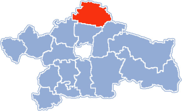
Coat of armsLocation within Białystok County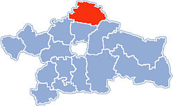
Coordinates (Czarna Białostocka): 53°18′N 23°17′E / 53.3°N 23.283°ECoordinates: 53°18′N 23°17′E / 53.3°N 23.283°E Country  Poland
Voivodeship Podlaskie County Białystok County Seat Czarna Białostocka Area – Total 206.54 km2 (79.7 sq mi) Population (2006) – Total 11,692 – Density 56.6/km2 (146.6/sq mi) – Urban 9,596 – Rural 2,096 Website http://www.czarnabialostocka.pl/ Gmina Czarna Białostocka is an urban-rural gmina (administrative district) in Białystok County, Podlaskie Voivodeship, in north-eastern Poland. Its seat is the town of Czarna Białostocka, which lies approximately 22 kilometres (14 mi) north of the regional capital Białystok.
The gmina covers an area of 206.54 square kilometres (79.7 sq mi), and as of 2006 its total population is 11,692 (out of which the population of Czarna Białostocka amounts to 9,596, and the population of the rural part of the gmina is 2,096).
The gmina contains part of the protected area called Puszcza Knyszyńska Landscape Park.
Villages
Apart from the town of Czarna Białostocka, Gmina Czarna Białostocka contains the villages and settlements of Brzozówka Koronna, Brzozówka Strzelecka, Brzozówka Ziemiańska, Budzisk, Burczak, Chmielnik, Czarna Wieś Kościelna, Czumażówka, Dworzysk, Horodnianka, Hutki, Jesienicha, Jezierzysk, Karczmisko, Klimki, Kosmaty Borek, Krzyżyki, Lacka Buda, Łapczyn, Łazarz, Machnacz, Niemczyn, Ogóły, Oleszkowo, Osierodek, Ośrodek, Podbrzozówka, Podratowiec, Podzamczysk, Ponure, Przewalanka, Ratowiec, Rogoziński Most, Ruda Rzeczka, Rudnia, Wilcza Jama, Wólka Ratowiecka, Zamczysk, Zdroje, Złota Wieś and Złotoria.
Neighbouring gminas
Gmina Czarna Białostocka is bordered by the gminas of Dobrzyniewo Duże, Janów, Jasionówka, Knyszyn, Korycin, Sokółka, Supraśl and Wasilków.
References

Villages Brzozówka Koronna • Brzozówka Strzelecka • Brzozówka Ziemiańska • Budzisk • Burczak • Chmielnik • Czarna Wieś Kościelna • Czumażówka • Dworzysk • Horodnianka • Hutki • Jesienicha • Jezierzysk • Karczmisko • Klimki • Kosmaty Borek • Krzyżyki • Lacka Buda • Łapczyn • Łazarz • Machnacz • Niemczyn • Ogóły • Oleszkowo • Osierodek • Ośrodek • Podbrzozówka • Podratowiec • Podzamczysk • Ponure • Przewalanka • Ratowiec • Rogoziński Most • Ruda Rzeczka • Rudnia • Wilcza Jama • Wólka Ratowiecka • Zamczysk • Zdroje • Złota Wieś • ZłotoriaUrban-rural gminas Gmina Choroszcz • Gmina Czarna Białostocka • Gmina Łapy • Gmina Michałowo • Gmina Supraśl • Gmina Suraż • Gmina Tykocin • Gmina Wasilków • Gmina Zabłudów
Rural gminas: Seat (not part of the county): Categories:- Gminas in Podlaskie Voivodeship
- Białystok County


Wikimedia Foundation. 2010.