- Gmina Michałowo
-
Gmina Michałowo
Michałowo Commune— Gmina — 
Coat of armsLocation within Białystok County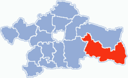
Coordinates (Michałowo): 53°2′12″N 23°36′13″E / 53.03667°N 23.60361°ECoordinates: 53°2′12″N 23°36′13″E / 53.03667°N 23.60361°E Country  Poland
Voivodeship Podlaskie County Białystok County Seat Michałowo Area – Total 409.19 km2 (158 sq mi) Population (2006) – Total 7,263 – Density 17.7/km2 (46/sq mi) Website http://michalowo.anawoj.org/ Gmina Michałowo is an urban-rural gmina (administrative district) in Białystok County, Podlaskie Voivodeship, in north-eastern Poland, on the border with Belarus. Its seat is the town of Michałowo, which lies approximately 31 kilometres (19 mi) east of the regional capital Białystok. (Michałowo gained town status on 1 January 2009 – prior to that the district was classed as a rural gmina.)
The gmina covers an area of 409.19 square kilometres (158.0 sq mi), and as of 2006 its total population is 7,263, out of which the population of Michałowo is 3,343.
The gmina contains part of the protected area called Puszcza Knyszyńska Landscape Park.
Villages
Apart from the town of Michałowo, the gmina contains the villages and settlements of Bachury, Bagniuki, Barszczewo, Bieńdziuga, Bołtryki, Bondary, Borsukowizna, Brzezina, Budy, Cisówka, Ciwoniuki, Dublany, Garbary, Gonczary, Gorbacze, Hieronimowo, Hoźna, Jałówka, Julianka, Juszkowy Gród, Kalitnik, Kamienny Bród, Kazimierowo, Kituryki, Kobylanka, Kokotowo, Kokotowo-Leśniczówka, Koleśne, Kondratki, Kopce, Kowalowy Gród, Krugły Lasek, Krukowszczyzna, Krynica, Kuchmy-Kuce, Kuchmy-Pietruki, Kuryły, Leonowicze, Lewsze, Maciejkowa Góra, Majdan, Marynka, Michałowo-Kolonia, Mościska, Mostowlany-Kolonia, Nowa Łuplanka, Nowa Wola, Nowe Kuchmy, Nowosady, Odnoga-Kuźmy, Osiedle Bondary, Oziabły, Pieńki, Pieńki-Kolonia, Planty, Pólko, Potoka, Rochental, Romanowo, Rudnia, Rybaki, Sacharki, Sokole, Stanek, Stara Łuplanka, Stare Kuchmy, Supruny, Suszcza, Świnobród, Szymki, Tanica Dolna, Tanica Górna, Tokarowszczyzna, Topolany, Tylwica, Tylwica-Kolonia, Tylwica-Majątek, Wierch-Topolany, Zajma, Zaleszany and Żednia.
Neighbouring gminas
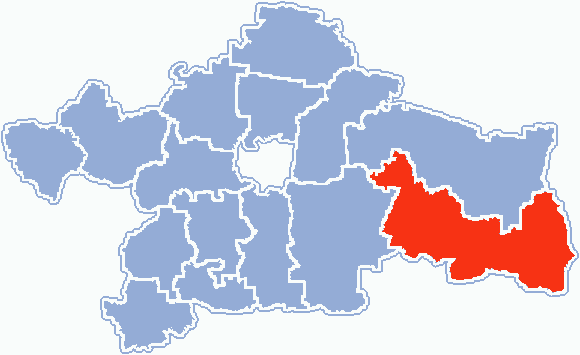
Gmina Michałowo is bordered by the gminas of Gródek, Narew, Narewka and Zabłudów. It also borders Belarus.
References
Urban-rural gminas Gmina Choroszcz • Gmina Czarna Białostocka • Gmina Łapy • Gmina Michałowo • Gmina Supraśl • Gmina Suraż • Gmina Tykocin • Gmina Wasilków • Gmina Zabłudów
Rural gminas: Seat (not part of the county): Categories:- Gminas in Podlaskie Voivodeship
- Białystok County


Wikimedia Foundation. 2010.