Croydon Flyover

Croydon Flyover
A slip road at a junction with Old Town heading up onto the flyover.

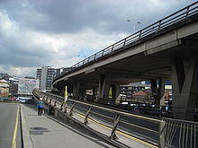
The Croydon Flyover is a flyover located in Croydon, London, England. It is part of the A232 road which connects Orpington with Ewell. The flyover connects Park Lane and the Croydon Underpass, on the A212 road with Duppas Hill Road.[1] It crosses over the A236, Old Town and Southbridge Road and the A212, Lower Coombe Street. The bypass also goes over Croydon High Street close to the Croydon Clocktower. The flyover was constructed as part of a ring road scheme conceived in the Croydon Plan of 1951 that has never been completed.

Landmarks passed on the flyover include the Fairfield Halls, a theatre and arts centre. The Dingwall Road multi-storey car park is entered via the bypass, plus you can see the new Centrale Shopping Centre. The nearest tube station is at Morden, six miles to the north-west, although there is a direct tram connection from Croydon to the District line terminus at Wimbledon.[2]

See also

References

Coordinates: 51°22′09″N 0°06′12″W / 51.3693°N 0.1033°W / 51.3693; -0.1033


Wikimedia Foundation. 2010.

Игры ⚽ Поможем написать реферат

Look at other dictionaries:

  • Croydon Underpass — is a underpass located in Croydon, London. The road is part of the A212 which stretches from Catford to Forestdale. Construction of the underpass beneath the junction of George Street and Wellesley Road/Park Lane during the early Sixties. The… …   Wikipedia

  • Croydon — For the larger local government district, see London Borough of Croydon. For other uses, see Croydon (disambiguation). Coordinates: 51°22′22″N 0°06′36″W /  …   Wikipedia

  • London Borough of Croydon — For other places called Croydon, see Croydon (disambiguation). For the historic town located within the London Borough which gives the name, see Croydon. London Borough of Croydon   London borough   …   Wikipedia

  • Old Town, Croydon — Old Town is a small neighbourhood and main road next to Croydon in the London Borough of Croydon. The road is a dual carriageway and forms part of the A236 which is a major A Road connecting both Mitcham and South Croydon. The road, heading from… …   Wikipedia

  • Hammersmith Flyover — is a flyover road in Hammersmith, west London. It was built in 1961 by Marples Ridgeway, a road construction company which was owned at the time by Conservative Transport Minister Ernest Marples. The flyover carries the A4 Great West Road over… …   Wikipedia

  • London and Croydon Railway — The London and Croydon Railway was opened in 1839 between London and Croydon in England.It shared the station at London Bridge with the London and Greenwich Railway and the line as far as Corbetts Lane Junction. Much of the route follows the… …   Wikipedia

  • List of churches in London — St. Paul s from the South London is the location of many famous churches, chapels and cathedrals, in a density unmatched anywhere else in England.[1] …   Wikipedia

  • A232 road — UK road routebox road= A232 length mi= length km= direction= East West start= Ewell destinations= Croydon Sutton end= Orpington construction date= completion date= junctions= ukroadsmall|21 ukroadsmall|23 gbroadsmall|24 ukroadsmall|212… …   Wikipedia

  • London Buses route 250 — Infobox London Bus number=250 operator=Arriva London garage=Thornton Heath Brixton vehicle=DAF DB250/Alexander ALX400 pvr=22 start=Croydon via=Thornton Heath Norbury Streatham end=Brixton length=8 miles (13 km) level=24 hour service… …   Wikipedia

  • A236 road — Coordinates: 51°22′16″N 0°05′57″W / 51.3710°N 0.0992°W / 51.3710; 0.0992 …   Wikipedia

Share the article and excerpts

Direct link
Do a right-click on the link above
and select “Copy Link”