Cowden, East Riding of Yorkshire

Cowden, East Riding of Yorkshire

Coordinates: 53°50′39″N 0°07′04″W / 53.844165°N 0.117834°W / 53.844165; -0.117834

Cowden
Cowden is located in East Riding of Yorkshire
Cowden

 Cowden shown within the East Riding of Yorkshire
OS grid reference TA239403
Parish Mappleton
Unitary authority East Riding of Yorkshire
Ceremonial county East Riding of Yorkshire
Region Yorkshire and the Humber
Country England
Sovereign state United Kingdom
Post town HULL
Postcode district HU11
Dialling code 01964
Police Humberside
Fire Humberside
Ambulance Yorkshire
EU Parliament Yorkshire and the Humber
UK Parliament Beverley and Holderness
List of places: UK • England • Yorkshire

Cowden (or Little Cowden) is a hamlet in the East Riding of Yorkshire, England, in an area known as Holderness. It is situated approximately 5 miles (8 km) south of Hornsea and lies just east of the B1242 road towards the North Sea coast.

It forms part of the civil parish of Mappleton.
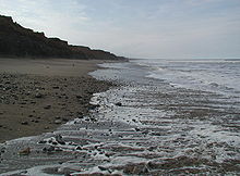
Lark Hill Beach

References

  • Gazetteer — A–Z of Towns Villages and Hamlets. East Riding of Yorkshire Council. 2006. p. 4. 


Wikimedia Foundation. 2010.

Игры ⚽ Поможем написать курсовую

Look at other dictionaries:

  • Cowden (disambiguation) — Cowden is a small village and civil parish in the Sevenoaks District of Kent, England. Cowden may also refer to: Cowden, East Riding of Yorkshire, England Cowden, Illinois, United States Cowden railway station, a railway station in Kent People… …   Wikipedia

  • List of places in Yorkshire — This is a list of cities, towns and villages in the historic English county of Yorkshire. See the list of places in England for places in other counties.See:List of civil parishes in the East Riding of Yorkshire, :List of civil parishes in North… …   Wikipedia

  • Great Cowden — infobox UK place country = England latitude= 53.866305 longitude= 0.130984 official name= Great Cowden population= civil parish= Mappleton unitary england = East Riding of Yorkshire region= Yorkshire and the Humber lieutenancy england= East… …   Wikipedia

  • Mappleton — Coordinates: 53°52′40″N 0°08′14″W / 53.877820°N 0.137317°W / 53.877820; 0.137317 …   Wikipedia

  • List of RAF stations — This List of RAF stations is a comprehensive list of all stations, airbases, airfields and administrative headquarters of the Royal Air Force past and present.:Note Current RAF Stations will be listed under the currently recognised county of the… …   Wikipedia

Share the article and excerpts

Direct link
Do a right-click on the link above
and select “Copy Link”