- Nyergesújfalu
-
Nyergesújfalu Location of Nyergesújfalu
 Nyergesújfalu
Coordinates: 47°45′24″N 18°32′56″E / 47.75678°N 18.54875°ECoordinates: 47°45′24″N 18°32′56″E / 47.75678°N 18.54875°E Country  Hungary
County Komárom-Esztergom Area – Total 39.51 km2 (15.3 sq mi) Population (2004) – Total 7,649 – Density 193.59/km2 (501.4/sq mi) Time zone CET (UTC+1) – Summer (DST) CEST (UTC+2) Postal code 2536 Area code(s) 33 Nyergesújfalu is a town in Komárom-Esztergom county, Hungary.
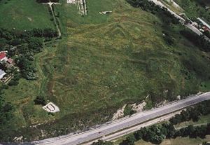 Aerialphotography: Nyergesújfalu, earthfort
The city, located near the river Danube, is an ancient site of habitation. Aerial photography has revealed the outline of an earthwork fort built centuries ago. It has become a destination for tourists and hikers; the latter take advantage of hills and trails in the region. Nyergesújfalu became a city officially in 1989.
Its baroque-style church was built in the 18th century, when Empress Mária Terézia granted land to the founders. Next to the church is the Salesian secondary school, where Attila József studied for a short time.
The city is associated with the noted painter Kernstock Károly (1873–1940), who inherited a house in Nyergesújfalu and lived here for several years. He was the center of an artistic community that created the modernist movement in Hungarian art.[1]
Contents
International relations
Main article: List of twin towns and sister cities in HungaryTwin towns — Sister cities
Nyergesújfalu is twinned with:
References
- ^ "Hungarian Hunt from Paris to Nagybanya, 1900-1914", Art Knowledge News, accessed 15 Sep 2010
External links
- Street map (Hungarian)
- "Nyergesújfalu", Tourist guide webpage (Hungarian)
County seat: TatabányaCities and towns 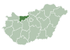
Villages Aka · Almásfüzitő · Annavölgy · Ácsteszér · Ászár · Baj · Bajna · Bajót · Bakonybánk · Bakonysárkány · Bakonyszombathely · Bana · Bársonyos · Bokod · Csatka · Császár · Csém · Csép · Csolnok · Dad · Dág · Dömös · Dunaalmás · Dunaszentmiklós · Epöl · Ete · Gyermely · Héreg · Kecskéd · Kerékteleki · Kesztölc · Kisigmánd · Kocs · Kömlőd · Környe · Leányvár · Máriahalom · Mocsa · Mogyorósbánya · Nagyigmánd · Nagysáp · Naszály · Neszmély · Piliscsév · Pilismarót · Réde · Sárisáp · Súr · Süttő · Szákszend · Szárliget · Szomód · Szomor · Tardos · Tarján · Tárkány · Tát · Tokod · Tokodaltáró · Úny · Várgesztes · Vérteskethely · Vértessomló · Vértesszőlős · VértestolnaOther topics History · Geography · Government · Economy · Culture · TourismCategories:- Populated places in Komárom-Esztergom county
- Komárom-Esztergom geography stubs


Wikimedia Foundation. 2010.