- New Jersey Route 5
-
Route 5
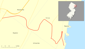
Route information Maintained by NJDOT Length: 3.18 mi[1] (5.12 km) Existed: 1927 (1916 as Route 10) – present Major junctions West end:  US 1-9 in Ridgefield
 Route 63 in Palisades Park
 Route 67 in Fort Lee
East end:  CR 505 in Edgewater
Highway system New Jersey State Highway Routes
Interstate and US←  Route 4
Route 6  →
→Route 5 is a 3.18-mile (5.12 km) state highway located entirely in Bergen County, New Jersey, United States. It runs from U.S. Route 1/9 in Ridgefield east down the New Jersey Palisades to end at County Route 505 (River Road) at the Hudson River in Edgewater. The route is a two- to four-lane undivided highway its entire length, passing mostly through wooded residential neighborhoods. The route passes over Route 63 in Palisades Park, with access to that route provided by Bergen Boulevard, and intersects the southern terminus of Route 67 in Fort Lee.
The route was designated in 1916 as part of pre-1927 Route 10, which was to run from Paterson east to the terminal of the Fort Lee Ferry in Edgewater, using the Paterson and Hackensack Turnpike between Paterson and Hackensack, the Bergen Turnpike from Hackensack to Ridgefield, and a new alignment between Ridgefield and Edgewater. In 1927, the route was renumbered to Route 5, with initial plans to build a new alignment for the route between Ridgefield and Little Ferry. Route 5 was also planned to run concurrent with Route 6 (now U.S. Route 46) between Paterson and Ridgefield. However, the plans were modified in 1929 to build Route 6 on a new alignment and have Route 5 end at Route 1 (now U.S. Route 1/9) in Ridgefield. The former alignment was designated as Route 10N with maintenance eventually turned over to the county. The eastern terminus of Route 5 was moved to its current location by the 2000s. In 2007, construction began to improve the route in Palisades Park by replacing bridges and widening the road, with work expected to be completed in later 2009.
Contents
Route description
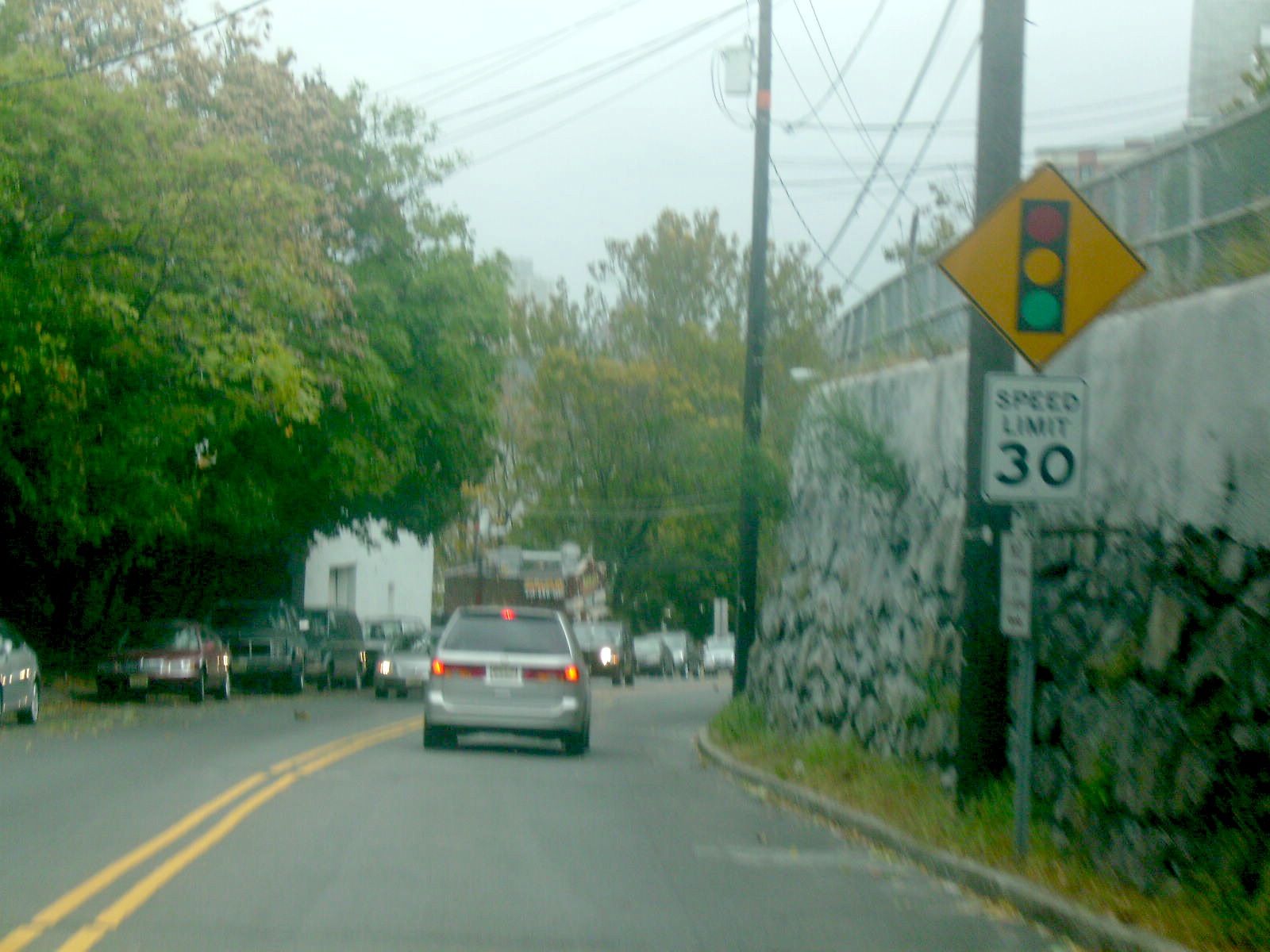
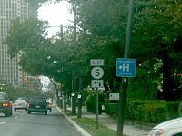 Route 5 eastbound on Palisade Avenue in Fort Lee, approaching the left turn to descend the New Jersey Palisades.
Route 5 begins at an intersection with U.S. Route 1/9 (North Broad Avenue) in Ridgefield, heading east as a two-lane undivided road through residential areas.[1][2] It crosses County Route 31 (Maple Avenue) and enters Palisades Park.[1] In Palisades Park, the road passes over Delia Avenue and turns south as it heads through wooded residential neighborhoods. Route 5 passes under Route 63 and enters Fort Lee, where the route immediately intersects Bergen Boulevard, which provides access to Route 63. From there, the road heads east through wooded neighborhoods before turning north onto Glen Road.
Route 5 comes to an intersection with County Route 29 (Anderson Avenue) and County Route 54 (Central Boulevard), where the route continues east on Central Boulevard as a four-lane undivided road through inhabited areas.[1][2] It meets the southern terminus of Route 67 (Palisade Avenue) and continues south along that road. After 0.36 mi (0.58 km) of following Palisade Avenue, Route 5 makes a left turn onto a two-lane road, with County Route 27 continuing south on Palisade Avenue.[1] The route descends the New Jersey Palisades on a winding road with hairpin turns, crossing into Edgewater. In Edgewater, the road briefly heads through commercial areas before ending at County Route 505 (River Road) along the Hudson River.[1][2]
History

Pre-1927 Route 10 was legislated in 1916 to run from Paterson east by way of Hackensack and Ridgefield to the Public Service Railway's Fort Lee Ferry at Edgewater. From Paterson it used the existing Paterson and Hackensack Turnpike (Market Street and Essex Street) to Hackensack and the Bergen Turnpike (Hudson Street) to Ridgefield.[3] Rather than use existing roads from Ridgefield down the Palisades to Edgewater, a whole new route was surveyed with better grades. This road was built by 1922. At its east end, Route 10 ran south several blocks on River Road to the ferry, just south of Dempsey Avenue. In Ridgefield, Broad Avenue was used to get between the new alignment and Bergen Turnpike.[4]
In the 1927 New Jersey state highway renumbering, Route 10 was renumbered to Route 5. Plans at the time were to build a new alignment from east of Ridgefield to Little Ferry southeast of Hackensack and form Route S5 (now Route 93) along the old road from Little Ferry to Ridgefield. The new Route 6 would share the alignment of Route 5 from Paterson to west of Hackensack, where it would turn southeast onto a new alignment to Little Ferry, then run with Route 5 again to east of Ridgefield and split onto its own alignment to the George Washington Bridge.[5][6]
 Route 10N
In 1929, the routes were redefined. Route 6 would be a completely new alignment from Paterson to the George Washington Bridge, and Route 5 would only run east from Route 1 (Broad Avenue, now U.S. Route 1/9) in Ridgefield.[7] The alignment of Route 10 west of Ridgefield was designated Route 10N until it was eventually turned over to the county.[8] Route 5 retained its routing in the 1953 New Jersey state highway renumbering.[9] By the 2000s, the section of Route 5 along River Road to the former ferry was removed.[10] In June 2007, construction began on a $24.6 million project to improve the route through Palisades Park. This project, which is to be completed later in 2009, will involve the replacement of the bridge over Delia Avenue, the removal of a bridge over an abandoned rail line, and the widening of the two-lane road to include a shoulder.[11]
Major intersections
The entire route is in Bergen County.
Location Mile[1] Destinations Notes Ridgefield 0.00 US 1-9 (Broad Avenue)Western terminus Fort Lee 0.92 Route 63Access provided by way of Bergen Boulevard 1.81 Route 67 north (Palisade Avenue)Edgewater 3.18 CR 505 (River Road)Eastern terminus 1.000 mi = 1.609 km; 1.000 km = 0.621 mi See also
 U.S. Roads portal
 New Jersey portal
References
- ^ a b c d e f g "Route 5 straight line diagram". New Jersey Department of Transportation. http://www.state.nj.us/transportation/refdata/sldiag/00000005__-.pdf. Retrieved 2007-04-08.
- ^ a b c Google, Inc. Google Maps – overview of New Jersey Route 5 (Map). Cartography by Google, Inc. http://maps.google.com/maps?f=d&source=s_d&saddr=route+5+and+route+1+ridgefield,+nj&daddr=route+5+and+river+road+edgewater,+nj&hl=en&geocode=&mra=ls&sll=40.897425,-74.056091&sspn=0.115483,0.219727&ie=UTF8&t=h&z=14. Retrieved 2009-03-11.
- ^ Williams, Jimmy and Sharon. "NJ 1920s Route 10". 1920s New Jersey Highways. http://www.jimmyandsharonwilliams.com/njroads/1920s/route10.htm. Retrieved 2009-03-11.
- ^ Williams, Jimmy and Sharon. "1922 Rand McNally Map - North". 1920s New Jersey Highways. http://www.jimmyandsharonwilliams.com/njroads/1920s/maps/1922rm1.jpg. Retrieved 2008-10-20.
- ^ State of New Jersey, Laws of 1927, Chapter 319.
- ^ Williams, Jimmy and Sharon. "1927 New Jersey Road Map". 1920s New Jersey Highways. http://www.jimmyandsharonwilliams.com/njroads/1920s/images/1927_routes.gif. Retrieved 2008-10-08.
- ^ State of New Jersey, Laws of 1929, Chapter 126.
- ^ State of New Jersey, Laws of 1939, complied.
- ^ 1953 renumbering. New Jersey Department of Highways. http://en.wikisource.org/wiki/1953_New_Jersey_state_highway_renumbering. Retrieved July 31, 2009.
- ^ Rand McNally (1996). United States-Canada-Mexico Road Atlas (Map).
- ^ "NJDOT announces Route 5 bridge replacement project in Palisades Park, Bergen County". New Jersey Department of Transportation. May 30, 2007. http://www.state.nj.us/transportation/about/press/2007/053007.shtm. Retrieved 2009-03-11.
External links
Categories:- Transportation in Bergen County, New Jersey
- State highways in New Jersey


Wikimedia Foundation. 2010.