Dunswell

Dunswell

Coordinates: 53°48′05″N 0°22′18″W / 53.801362°N 0.371749°W / 53.801362; -0.371749

Dunswell
Dunswell is located in East Riding of Yorkshire
Dunswell

 Dunswell shown within the East Riding of Yorkshire
OS grid reference TA073351
Parish Woodmansey
Unitary authority East Riding of Yorkshire
Ceremonial county East Riding of Yorkshire
Region Yorkshire and the Humber
Country England
Sovereign state United Kingdom
Post town HULL
Postcode district HU6
Dialling code 01482
Police Humberside
Fire Humberside
Ambulance Yorkshire
EU Parliament Yorkshire and the Humber
UK Parliament Haltemprice and Howden[1]
List of places: UK • England • Yorkshire

Dunswell is a village in the East Riding of Yorkshire, England in an area known as Holderness. It is situated approximately 4 miles (6.4 km) north of Hull city centre and 3.5 miles (5.6 km) south east of the market town of Beverley. It lies on the A1174 road and west of the River Hull.
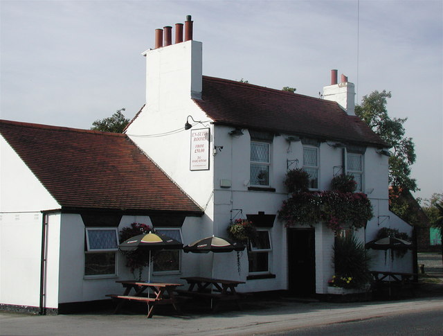
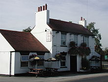
The Ship, Dunswell

It forms part of the civil parish of Woodmansey.

The village has a football team, Hall Road Rangers, which plays in the Northern Counties East League Division One.

Governance

The village was in the Beverley and Holderness parliamentary constituency until the 2010 general election when it was transferred to the constituency of Haltemprice and Howden.[1]

References

  1. ^ a b "Are you ready to vote in the next election?". East Riding News (East Riding of Yorkshire Council): p. 3. April 2010. 
  • Gazetteer — A–Z of Towns Villages and Hamlets. East Riding of Yorkshire Council. 2006. p. 5. 


Wikimedia Foundation. 2010.

Игры ⚽ Нужна курсовая?

Look at other dictionaries:

  • Dunswell — Original name in latin Dunswell Name in other language State code GB Continent/City Europe/London longitude 53.80106 latitude 0.37139 altitude 2 Population 1682 Date 2013 07 11 …   Cities with a population over 1000 database

  • Dunhill — Recorded in a range of spellings including Dunswell, Dunwell, and the either developed form or separate forms Dunnell, Dunnill, Dunill, Dunhill, and Dunhills, this is an English locational surname. It originates either from the hamlet of Dunswell …   Surnames reference

  • Hall Road Rangers F.C. — Infobox Football club clubname = Hall Road Rangers fullname = Hall Road Rangers Football Club nickname = Rangers founded = 1959 chairman = Robert Smailes manager = Steve Richards ground = Dene Park Dunswell, Hull capacity = 1200 ( 250 seats )… …   Wikipedia

  • Donwell — Recorded in a wide range of spellings including Denwell, Donwell, Dunwell, Dunhill, Dunnell, Dunnill, and Dunswell, this is an English locational surname. It originates from a little hamlet called Dunswell, meaning brown stream , near the town of …   Surnames reference

  • Leven Canal — The Leven Canal canal runs for 3.25 miles (5.1 km) from the River Hull to the village of Leven, East Riding of Yorkshire, England. It was built for Mrs Charlotta Bethell in 1805, and remained in use until 1935. It is now a Site of Special… …   Wikipedia

  • List of places in Yorkshire — This is a list of cities, towns and villages in the historic English county of Yorkshire. See the list of places in England for places in other counties.See:List of civil parishes in the East Riding of Yorkshire, :List of civil parishes in North… …   Wikipedia

  • Haltemprice and Howden (UK Parliament constituency) — UK constituency infobox Name = Haltemprice and Howden Map1 = HaltempriceHowden Type = County Map2 = Humberside Entity = Humberside County = East Riding of Yorkshire Year = 1997 MP = David Davis Party = Conservative EP = Yorkshire and the… …   Wikipedia

  • A1079 road — UK road routebox road= A1079 length mi= length km= direction= East West start= Kingston upon Hull destinations= Beverley end= York construction date= completion date= junctions= ukroadsmall|63 ukroadsmall|165 ukroadsmall|1174 ukroadsmall|1033… …   Wikipedia

  • Woodmansey — infobox UK place country = England latitude = 53.826710 longitude = 0.398419 official name = Woodmansey static static image caption = St Peter s Church, Woodmansey population = 6,497 (2001 census) civil parish = Woodmansey unitary england = East… …   Wikipedia

  • Beverley Road — is one of several major roads that run out of the city of Hull in the East Riding of Yorkshire, England. It runs North from Hull city centre and carries the designation of A1079. Upon leaving the city boundaries, Beverley Road continues north… …   Wikipedia

Share the article and excerpts

Direct link
Do a right-click on the link above
and select “Copy Link”