- Marais-Vernier
-
Marais-Vernier

 Marais-VernierLocation within Upper Normandy region
 Marais-Vernier
Administration Country France Region Upper Normandy Department Eure Arrondissement Bernay Canton Quillebeuf-sur-Seine Intercommunality Quillebeuf-sur-Seine Mayor Claude Blondel
(2008–2014)Statistics Elevation 0–113 m (0–371 ft)
(avg. 10 m/33 ft)Land area1 24.98 km2 (9.64 sq mi) Population2 498 (2008) - Density 20 /km2 (52 /sq mi) INSEE/Postal code 27388/ 27680 1 French Land Register data, which excludes lakes, ponds, glaciers > 1 km² (0.386 sq mi or 247 acres) and river estuaries. 2 Population without double counting: residents of multiple communes (e.g., students and military personnel) only counted once. Coordinates: 49°25′26″N 0°27′16″E / 49.4238888889°N 0.454444444444°E
Marais-Vernier (French pronunciation: [ma.ʁɛ vɛʁ.nje]) is a commune in the Eure department in Haute-Normandie in northern France.
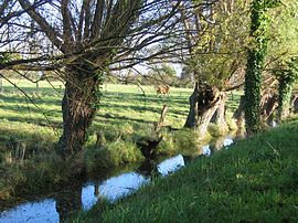
The river ends with the Seine on the left bank near Quillebeuf-sur-Seine. It is isolated from a river by a ditch which was constructed by the Dutch.
Its landscape is used for farming while forests are founded on its hills and bogs and le Grand Mare where a number of species of birds are founded. Horses from Camargue and oxen from Scotland (Highland Cattle) are founded along with storks. The area also has cliffs keeping the village insulated and is made up of thatched cottages.
Contents
Population
Historical population of Marais-Vernier 1962 1968 1975 1982 1990 1999 2008 482 495 502 464 480 455 498 Economy
Its principal agriculture are cattle.
See also
References
External links
- Website of the Commune Le-Marais-Vernier
- Country Risle Estuaire
- Normandy Tourism - Official Site C.R.T. Normandy
- Federation Regional Tourist Country Home
- Normandy Tour
- Normandie Qualité Tourisme
- Comité Départemental du Tourisme de l'Eure
- Eure 27 Normandy
- Office de Tourisme d'Evreux
Categories:- Communes of Eure
- Eure geography stubs


Wikimedia Foundation. 2010.