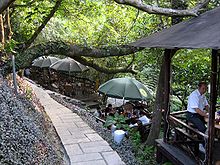
- Maokong
-
Maokong (Chinese: 貓空; pinyin: Māokōng; Pe̍h-ōe-jī: niau-khang; literally "cat empty") is located in Wenshan District of Taipei, Taiwan. The area used to be the biggest tea growing area of Taipei. There are many intertwining footpaths which have been used to transport tea. Now, it is a popular place for tea culture and viewing the night scenery of Taipei City.[1]
The name comes from "jiâu-khang" (皺空, also similar 皺孔) in Taiwanese Hokkien, which means "crease aperture" and refers to pothole formations. During Japanese rule it was changed to the similar sounding Maokong (貓空)[2].
Contents
Features
Maokong is a suburb of Taipei. It sits on the edge of Taipei Basin; the entire city of Taipei can be seen from the mountain, especially on a cloudless day.
There are many pathways for hiking such as from the National Chengchi University at the foot of the hill to the top of the mountain. On weekends many people come to Maokong for go hiking and climbing.
Maokong still produces some tea, most notably tieguanyin tea. Many restaurants in the area offer both good tea and food. A combination of traditional tea culture, food, and scenery are the main reasons the area has become a popular tourist destination.
Transportation
The Maokong Gondola, a gondola lift system, started operations on July 4, 2007. It connects to the Wenshan Line of the Taipei Metro at Taipei Zoo. The gondola was designed to make visiting Maokong more convenient for local residents and tourists. Service was suspended on October 1, 2008 due to erosion from mudslides under a support pillar.[3] The gondola officially resumed service as of March 31, 2010, after relocation of the pillar and passing safety inspections.[4]
See also
- Tourism in Taiwan
References
- ^ Maokong Tea Culture
- ^ The origin of the name.
- ^ "FEATURE: Halted gondola confirms worries". Taipei Time. October 14, 2008. http://www.taipeitimes.com/News/taiwan/archives/2008/10/14/2003425826. Retrieved August 6, 2009.
- ^ The China Post News Staff (2010-03-31). "Maokong Gondola reopens, featuring glass-bottomed car". The China Post. http://www.chinapost.com.tw/taiwan/local/taipei/2010/03/31/250500/Maokong-Gondola.htm. Retrieved 2010-04-03.
External links
Categories:- Districts of Taipei
- Taiwan geography stubs
Wikimedia Foundation. 2010.


