- Chennai Metropolitan Area
-
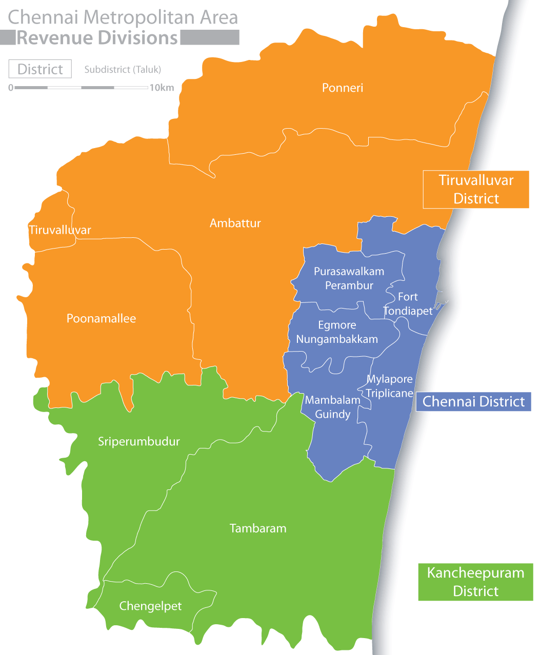
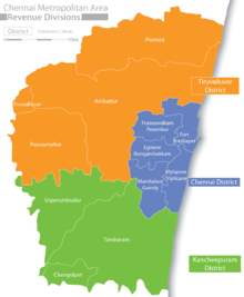 Districts and Taluks of the metropolitan area
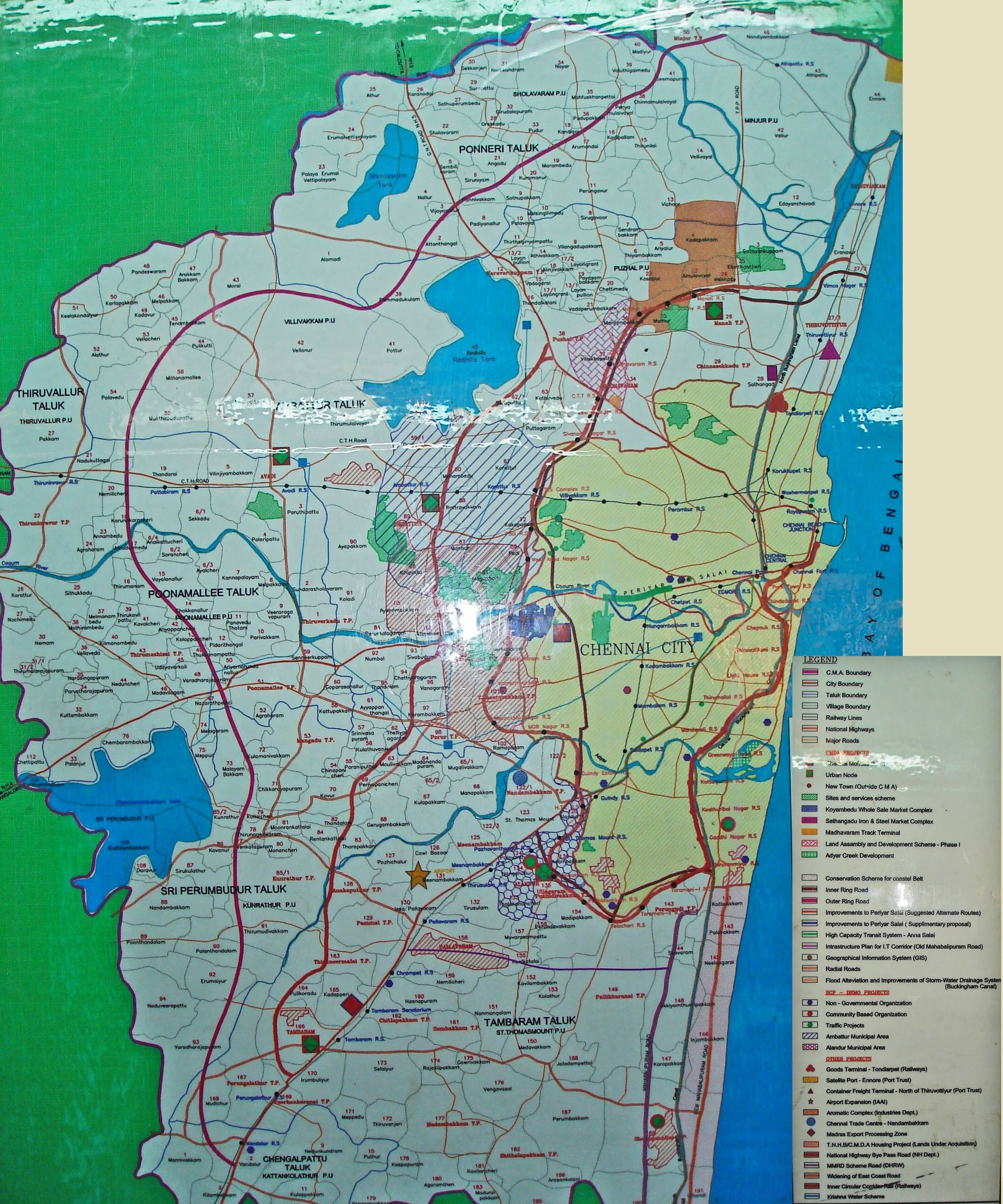
 The CMDA masterplan for the CMA
The Chennai Metropolitan Area (Tamil: சென்னை மாநகர பரப்பு) is the fourth largest metropolitan area in India and the 30th in the world in terms of population (as of 2010[update]). The CMA consists of the metropolitan city of Chennai (Madras) and its suburbs. The Chennai Metropolitan Development Authority (CMDA) is the nodal agency that handles town planning and development within the metro area. Since 1974, an area encompassing 1189 km2 around the city has been designated as the Chennai Metropolitan Area (CMA) and the CMDA has been designated as the authority to plan the growth of the city and the area around it.
Contents
Composition
The CMA has an area of 1189 km² spread over three districts.
Sn District Area (km²)[1] Population (2001) 1 Chennai district (City of Chennai) 176 4,661,834 2 Thiruvallur district 637 1,574,847 3 Kancheepuram district 376 1,107,789 Total 1,189 7,344,470 Nodal agencies
Sn Agency Responsibility 1 Chennai Corporation (Madras Corporation), Municipalities and Panchayats Civic management in their area of jurisdiction 2 Tamil Nadu Housing Board provision of plots and ready built houses, Sites and Services schemes
3 Metropolitan Transport Corporation Bus Transport 4 Southern Railway Chennai suburban railway and Chennai MRTS 5 Chennai City Traffic Police Traffic Management Schemes 6 Tamil Nadu Electricity Board Electricity generation and supply 7 Public Works Department Implementation & Maintenance of macro drainage system
8 Chennai Metropolitan Development Authority Urban planning, co -ordination of project implementation
9 Chennai Metropolitan Water Supply and Sewerage Board Water Supply & Sewerage facilities for CMA 10 Tamil Nadu Slum Clearance Board Provision of housing, infrastructure and livelihood programs in slum areas
11 Aavin Co operative society Providing Milk through co-operative society to the people of Chennai Profile
Chennai (Madras), the capital City of Tamil Nadu is the fourth largest Metropolitan City in India. The Chennai Metropolitan Area (CMA) comprises the city of Chennai, 16 Municipalities, 20 Town Panchayats and 214 Village Panchayats in 10 Panchayat Unions. The extent of CMA is 1189 km2.
The CMA falls in three Districts of the Tamil Nadu State viz. Chennai District, part of Thiruvallur District, and part of Kancheepuram District. The extent of the Chennai District (covered in Chennai Municipal Corporation area) is176 km2 and comprises 55 revenue villages in five Taluks [viz. (i) Fort-Tondiarpet Taluk, (ii) Perambur-Purasawalkam Taluk, (iii) Egmore-Nungambakkam Taluk, (iv) Mambalam-Guindy Taluk and (v) Mylapore-Triplicane Taluk. In Thiruvallur District out of total district area of 3427 km2, 637 km2. in Ambattur, Thiruvallur, Ponneri and Poonamallee taluks fall in CMA. In Kancheepuram District out of 4433 km2, 376 km2 in Tambaram, Sriperumbudur and Chengalpattu Taluks fall in the Metropolitan area.
Master Plan prepared by CMDA
The State government will decide on the expansion of the Chennai Metropolitan Area (CMA) before the end of this fiscal, R Vaithilingam, Minister for Housing and Urban Development, told the Assembly on Aug 25, 2011. In view of the fast-paced development taking place in areas beyond the present metropolitan area jurisdiction, like Sriperumbudur, Kelambakkam, Tiruvallur and Maraimalai Nagar, it had become necessary to review the Chennai Metropolitan Planning Area that was notified in 1973-74, he said.[2]
The present CMA was limited to 1,189 km2 which was the smallest in extent in the country. “In other cities, including Delhi, Mumbai, Bangalore and Kolkata, larger regions have been declared as metropolitan area and comprehensive regional planning is being made.” The need for a larger planning area around Chennai was being examined and a detailed report was prepared by the Chennai Metropolitan Development Authority (CMDA) for the government’s consideration.
“A decision will be taken before the end of this fiscal,” he informed. “Alongside the proposed expansion of the Corporation limits, the decision to go in for a greater CMA limit would have a synergetic effect. It would support better infrastructure and facilities for the people besides decongesting the city.”
In the face of rapid increase in population in the districts surrounding Chennai and the expansion of the city, a new regional planning model on the lines of National Capital Region, Delhi, is being examined by the Chennai Metropolitan Development Authority (CMDA). In order to plan for balanced regional development, developing a larger road network, implementing an integrated transport plan and identifying a Chennai Mega Region have become necessary.[3]
References
Categories:- Metropolitan areas of India
Wikimedia Foundation. 2010.