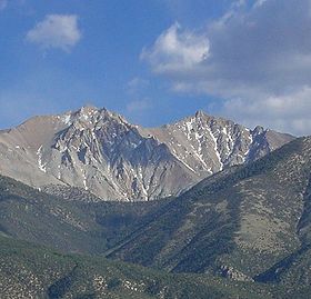
- Montgomery Peak
-
Montgomery Peak 
Montgomery and Boundary PeakElevation 13,441 ft (4,097 m) [1] Prominence 1,266 ft (386 m) [1] Parent peak Mount Dubois [2] Location Location Mono County, California, USA Range White Mountains Coordinates 37°50′18″N 118°21′24″W / 37.8382642°N 118.3567847°WCoordinates: 37°50′18″N 118°21′24″W / 37.8382642°N 118.3567847°W[3] Topo map USGS Boundary Peak Climbing Easiest route Hike Montgomery Peak is a mountain in the White Mountains of California, USA. It is less than 1 mile (1.6 km) from Boundary Peak, the highest point in Nevada. It can be climbed in combination with Boundary Peak.
References
- ^ a b "Montgomery Peak, California". Peakbagger.com. http://www.peakbagger.com/peak.aspx?pid=3626. Retrieved 2009-02-17.
- ^ "Mount Dubois - California Mountain Atlas". Peaklist.org. http://www.peaklist.org/CAmtnatlas/tables/telescope_white/dubois.html. Retrieved 2009-01-18.
- ^ "Montgomery Peak". Geographic Names Information System, U.S. Geological Survey. http://geonames.usgs.gov/pls/gnispublic/f?p=gnispq:3:::NO::P3_FID:263775. Retrieved 2009-02-17.
Categories:- Mountains of Mono County, California
- California geography stubs
Wikimedia Foundation. 2010.
