- Massacre Rocks State Park
-
Massacre Rocks State Park Idaho State Park 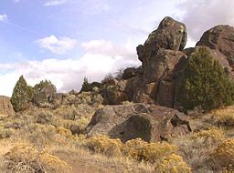 Boulders in Massacre Rocks State Park deposited during the Bonneville Flood
Country  United States
State  Idaho
IdahoCounty Power Location American Falls - elevation 4,400 ft (1,341 m) - coordinates 42°43′36″N 112°55′59″W / 42.72667°N 112.93306°W Area 990 acres (400.6 ha) Founded 1967 Management Idaho Department of Parks and Recreation 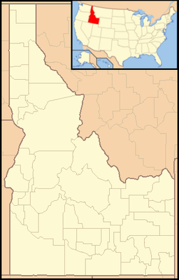
 Location of Massacre Rocks State Park in Idaho
Massacre Rocks State Park is a state park of Idaho, USA, featuring the Massacre Rocks, a famous spot along the Oregon Trail and California Trail during the middle 19th century. The park is located in Power County, along the Snake River west of American Falls.
Description
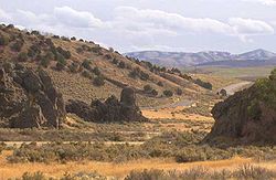 Massacre Rocks, viewed from the Visitor Center
The park features a famous configuration of boulders along the south bank of the Snake River along the trail, known alternatively as Massacre Rocks, "Gate of Death", or "Devil's Gate". Emigrants gave this name to the narrow passage of the trail through the rocks, from the fear of possible ambush by Native Americans. According to diaries of emigrants, settlers in five wagons clashed with Shoshoni just east of the rocks on August 9–10, 1862. Ten emigrants died in the fight, which involved four wagon trains. The skirmishes took place east of the park and not at Devil's Gate as commonly believed. Some confrontations may have occurred there, but they remain unverified.[1] The Clark Massacre of 1851 occurred just west of Massacre Rocks, closer to the Raft River.
The rocks were often used as campsite for wagon trains along the trail. Many emigrants carved their names and dates on the rock face, which is now protected by a shelter.[2] The actual passage through the rocks is now the route of Interstate 86 along the south edge of the park.
Geologically the park was created during the repeated volcanic activity on the Snake River Plain. The rocks themselves were deposited in their present location at the end of the last ice age, approximately 14,500 years ago, during the catastrophic flood known as the Bonneville Flood, when much of Lake Bonneville surged down the Snake River.[1] A notch in the cliff on the north bank of the Snake opposite the park was the site of an ancient waterfall of a side channel of the waters in the aftermath of the flood.
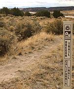 Ruts of the Emigrant Trail near Massacre Rocks
The park also includes a visitor center describing the history and geology of the park. It has access to the Snake River, as well as a campground. It is accessible by automobile on Interstate 86. It is also accessible on a foot trail from nearby rest areas just east of the park on Interstate 86. The footpaths also provide access to remnants of the original Oregon Trail on the south side of the highway.[2]
Massacre Rocks became a state park in 1967, having previously been a roadside park managed by the Idaho Department of Transportation.[3]
References
- ^ a b Digital Atlas of Idaho. "Massacre Rocks". Idaho Museum of Natural History. http://imnh.isu.edu/digitalatlas/geog/parks/massacre/massacre.htm. Retrieved 2011-03-05.
- ^ a b Idaho Department of Parks and Recreation. "Massacre Rocks State Park". http://parksandrecreation.idaho.gov/parks/massacrerocks.aspx. Retrieved 2011-03-05.
- ^ "State Lands in Idaho: History". Idaho Museum of Natural History. http://imnh.isu.edu/digitalatlas/geog/publrecr/text/stlndmn.htm. Retrieved 2011-03-05.
External links
Federal National ParksNational MonumentsNational ForestsBitterroot • Boise • Caribou-Targhee • Clearwater • Coeur d'Alene • Idaho Panhandle • Kaniksu • Kootenai • Nez Perce • Payette • Salmon-Challis • Sawtooth • St. Joe • Wallowa–Whitman • Wasatch-CacheNational Wildlife RefugesBear Lake • Camas • Deer Flat • Grays Lake • Kootenai • Minidoka • Oxford Slough Waterfowl Production AreaBig Jacks Creek • Bruneau-Jarbidge Rivers • Craters of the Moon • Frank Church-River of No Return • Gospel Hump • Hells Canyon • Little Jacks Creek • North Fork Owyhee • Owyhee River • Pole Creek • Selway-Bitterroot • SawtoothState Bear Lake • Bruneau Dunes • Castle Rocks • City of Rocks • Coeur d'Alene Parkway • Dworshak • Eagle Island • Farragut • Harriman • Hells Gate • Henrys Lake • Heyburn • Lake Cascade • Lake Walcott • Land of the Yankee Fork • Lucky Peak • Massacre Rocks • McCroskey • Old Mission • Ponderosa • Priest Lake • Round Lake • Thousand Springs • Three Island Crossing • Trail of the Coeur d'Alenes • Winchester Lake •Idaho Department of Parks & Recreation (website) Categories:- California Trail
- Idaho state parks
- Oregon Trail
- Protected areas of Power County, Idaho
- Protected areas established in 1967
- Snake River


Wikimedia Foundation. 2010.