- Trail of the Coeur d'Alenes
-
Trail of the Coeur d'Alenes 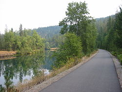
Trail of the Coeur d'Alenes as it follows the Coeur d'Alene River Length 73 miles (117 km) Location Idaho Panhandle Trailheads Mullan, Idaho
Plummer, IdahoUse Biking, in-line skating, hiking Trail difficulty Easy Season Year-round Sights Silver Valley, Lake Coeur d'Alene, Heyburn State Park, Palouse The Trail of the Coeur d'Alenes is a rail trail in Idaho, USA, which follows the former Union Pacific Railroad right-of-way from Mullan, a mountain mining town near the Montana border, to Plummer, a town on the prairie near the Washington border.
The trail's 73-mile (117 km) route winds through the mountainous terrain of the historic Silver Valley, into the chain lakes region, along the shore of Lake Coeur d'Alene, over the Chatcolet Bridge to Heyburn State Park, and finally climbs to the Palouse prairie. Trail users can continue along a bike path in Washington that will eventually lead to Spokane.
The Trail of the Coeur d'Alenes includes camping facilities and rest areas regularly. The trail leads through protected marsh lands, offering the cyclist a glimpse of eagle and osprey nests, moose, elk, and a variety of ducks and other wildlife, as well as some rare species of wildflowers and accompanying butterflies as a result of the age-old soot from the old railroad.
The trail is not only a recreational facility, but also a solution to environmental problems left behind by Idaho's mining industry. Silver was discovered in the valley around 1884, and a rail line was built to access the mines around 1888. Much of the rock in the railbed was either waste rock from mines, or tailings containing heavy metals. The railbed was also contaminated with spillage from passing trains. To remedy these environmental problems, the Union Pacific Railroad, U.S. Government, the State of Idaho, and the Coeur d'Alene Tribe partnered to build a trail. The thick asphalt and the gravel barriers on the sides of the trail serve as a permanent cap to isolate contaminants from the surrounding environment.
References
External links
Coordinates: 47°30′35″N 116°32′13″W / 47.50972°N 116.53694°W
Federal National ParksNational MonumentsNational ForestsBitterroot • Boise • Caribou-Targhee • Clearwater • Coeur d'Alene • Idaho Panhandle • Kaniksu • Kootenai • Nez Perce • Payette • Salmon-Challis • Sawtooth • St. Joe • Wallowa–Whitman • Wasatch-CacheNational Wildlife RefugesBear Lake • Camas • Deer Flat • Grays Lake • Kootenai • Minidoka • Oxford Slough Waterfowl Production AreaBig Jacks Creek • Bruneau-Jarbidge Rivers • Craters of the Moon • Frank Church-River of No Return • Gospel Hump • Hells Canyon • Little Jacks Creek • North Fork Owyhee • Owyhee River • Pole Creek • Selway-Bitterroot • SawtoothState Bear Lake • Bruneau Dunes • Castle Rocks • City of Rocks • Coeur d'Alene Parkway • Dworshak • Eagle Island • Farragut • Harriman • Hells Gate • Henrys Lake • Heyburn • Lake Cascade • Lake Walcott • Land of the Yankee Fork • Lucky Peak • Massacre Rocks • McCroskey • Old Mission • Ponderosa • Priest Lake • Round Lake • Thousand Springs • Three Island Crossing • Trail of the Coeur d'Alenes • Winchester Lake •Idaho Department of Parks & Recreation (website)Categories:- Protected areas of Benewah County, Idaho
- Idaho state parks
- Protected areas of Kootenai County, Idaho
- Rail trails in Idaho
- Protected areas of Shoshone County, Idaho

Wikimedia Foundation. 2010.