- Drake's Island
-
"St Nicholas Island" redirects here. For the Californian Channel Island, see San Nicolas Island.
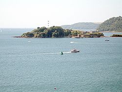
 Drake's Island as seen from Plymouth Hoe.
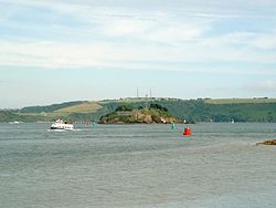
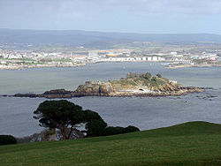
Drake's Island is a 6.5 acres (2.6 ha) island lying in Plymouth Sound, the stretch of water south of the city of Plymouth, Devon, England. The rocks which make up the island are volcanic tuff and lava, together with marine limestone of the mid-Devonian period[1].
Contents
Early history
The first recorded name for the island was in 1135, when it was referred to as St Michael's, after the chapel erected on it. At some later date the chapel was rededicated to St Nicholas and the island adopted the same name. From the latter part of the 16th century the island was occasionally referred to as Drake's Island after Sir Francis Drake, the English privateer who used Plymouth as his home port. Even well into the 19th century, maps and other references continued to refer to the island as St Nicholas's Island and it is only in about the last 100 years that this name has slipped into disuse and the name Drake's Island has been adopted.
It was from here that Drake sailed in 1577, to return in 1580 having circumnavigated the world, and in 1583 Drake was made governor of the island. From 1549 the island began to be fortified as a defence against the French and Spanish, with barracks for 300 men being built on the island in the late 16th century.
For several centuries, the island remained the focal point of the defence of the three original towns that were to become modern Plymouth. In 1665 the Roundhead Robert Lilburne died imprisoned on the island. He had been sentenced to life imprisonment for his part in the Regicide of Charles I. A few years later John Lambert, a Roundhead General, was moved to Drake's Island from Guernsey, where he had been imprisoned since 1662. He never regained his liberty, dying on Drake's Island in the winter of 1683.
In June 1774 the first recorded submarine fatality in history occurred north of Drake's Island, when a carpenter named John Day perished while testing a wooden diving chamber attached to the sloop Maria.[2]
Drake's Island Battery
The 1859 Royal Commission on the Defence of the United Kingdom recommended a huge programme of new fortifications to defend Plymouth. On Drake's Island, the existing battery at the centre of the island was to be replaced by five 12-inch muzzle loading guns in open emplacements. A new battery was to be built on the southwestern end, of twenty one 9-inch guns in an arc of stone casemates with iron shields. The work was not complete in 1880. Six 12-pounder quick firing guns were added in 1897 and three 6-inch guns became the main armament in 1901; the original muzzle loaders were dumped under a pile of earth[3]. Finally. in 1942, a modern twin 6-pounder gun was installed.[4]
Recent history
Following World War II Drake's Island remained under the administration of the War Office, which, despite having announced in 1956 that it was no longer needed for defence purposes, did not finally vacate the island until 1963, when Plymouth City Council obtained a lease from the Crown with the aim of establishing a youth adventure training centre there. This centre was opened in 1964, the year in which a mains water supply finally reached the island.
On 1 May 1987 the island got its first telephone line, using a cable attached to the mains water pipe. The telephone number was Plymouth 63393. The warden had previously used the Ministry of Defence system. Shortly afterwards, on 31 March 1989, the Mayflower Trust surrendered their lease and sold off the boats and sports equipment. Ownership reverted to the Crown.
Drake's Island Adventure Centre, under the custody of the Mayflower Centre Trust, operated until the surrender of the lease in 1989.
Former Plymouth Argyle chairman, Dan McCauley bought the island for £384,000 from the Crown Estate in 1995. As of 2005 it contains derelict military barracks and buildings from the Napoleonic era, and a MoD radio mast. In 2003, Plymouth City Council turned down a planning application from McCauley to build a hotel and leisure complex replete with helipad.
In May 2005 the island attracted British media attention when one of the empty buildings on the island was squatted by a group of anti-nuclear protestors, Trident Ploughshares.[5]
1995
In 1995, Drake's Island came up for sale by the Crown Estates with an asking price of £235,000.00 and had numerous offers on the table,in the end,a bidding war commenced between former Plymouth Argyle chairman, Dan McCauley and a Cheshire born business man which wanted to open it to the public, Dan McCauley was successful and has had plans to turn it into a hotel complex for many years though this has not yet happened.[6]
References
- ^ "CJO - Abstract - IV.—Nappie's Island, Plymouth". Journals.cambridge.org. 2009-05-01. http://journals.cambridge.org/action/displayAbstract;jsessionid=C4F0E58FC0B77E434A559CDA81B4E67B.tomcat1?fromPage=online&aid=5430528. Retrieved 2010-02-12.
- ^ Ecott, Tim (2001). Neutral Buoyancy: Adventures in a Liquid World. New York: Atlantic Monthly Press, ISBN 0-87113-794-1
- ^ "Plymouth`s Napoleonic Fortifications, UK". Cyber-heritage.co.uk. 1907-02-02. http://www.cyber-heritage.co.uk/fort/fort.htm. Retrieved 2010-02-12.
- ^ "Drakes Island" (PDF). palmerstonforts.org.uk. http://www.palmerstonforts.org.uk/pdf/drake.pdf. Retrieved 2010-02-12.
- ^ "Protesters set up camp on island". BBC News. 2005-05-13. http://news.bbc.co.uk/1/hi/england/devon/4545133.stm. Retrieved 2010-02-12.
- ^ "McCauley: It's my fault Drake's Island is on at-risk list". Thisisexeter.co.uk. http://www.thisisexeter.co.uk/news/McCauley-s-fault-island-risk-list/article-1097046-detail/article.html. Retrieved 2010-02-12.
External links
Categories:- Islands of England
- Plymouth, Devon
- Coastal artillery
- Palmerston Forts
Wikimedia Foundation. 2010.


