- Mill Creek (western West Virginia)
-
Mill Creek 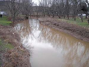 Mill Creek in Ripley in 2007
Country United States State West Virginia Tributaries - left Tug Fork Source Elk Fork - location western Roane County - elevation 1,021 ft (311 m) [1] - length 15.4 mi (25 km) [2] - coordinates 38°45′18″N 81°28′55″W / 38.755°N 81.48194°W [3] Secondary source Little Mill Creek - location northwestern Roane County - elevation 976 ft (297 m) [1] - length 11.1 mi (18 km) [2] - coordinates 38°49′15″N 81°29′36″W / 38.82083°N 81.49333°W [4] Source confluence - location east of Ripley - elevation 610 ft (186 m) [4] - coordinates 38°48′18″N 81°38′19″W / 38.805°N 81.63861°W [5] Mouth Ohio River - location Millwood - elevation 554 ft (169 m) [5] - coordinates 38°53′04″N 81°51′43″W / 38.88444°N 81.86194°W [5] Length 29.4 mi (47 km) Basin 234 sq mi (606 km2) 
 Location of the mouth of Mill Creek in Millwood, West Virginia
- For other uses, including other streams in West Virginia named Mill Creek, see Mill Creek.
Mill Creek is a tributary of the Ohio River, 29.4 miles (47.3 km) long,[2] in western West Virginia in the United States. Via the Ohio, it is part of the watershed of the Mississippi River, draining an area of 234 square miles (610 km2)[6] on the unglaciated portion of the Allegheny Plateau. According to the Geographic Names Information System, it has also been known historically as Big Mill Creek.[5]
Mill Creek is formed approximately 4 miles (6.4 km) east of the city of Ripley in central Jackson County by the confluence of streams known as the Elk Fork[3] and Little Mill Creek.[4] The Elk Fork, 15.4 miles (24.8 km) long,[2] rises in western Roane County and flows generally northwestward. Little Mill Creek, 11.1 miles (17.9 km) long,[2] rises in northwestern Roane County and flows generally westward.[7] Shortly downstream of their confluence, Mill Creek collects an 11.9-mile (19.2 km) long[2] tributary known as the Tug Fork,[8] which is formed in southern Jackson County by the confluence of the Bear Fork and Grasslick Creek, and flows northwestward, past the community of Statts Mills, joining Mill Creek from the south.[7]
Mill Creek flows generally west-northwestward in a winding course through central and western Jackson County, through the city of Ripley, which may have been named for Harry Ripley, a traveling preacher said to have drowned in the creek in 1830.[9] Downstream of Ripley, the stream passes through a broad valley in the vicinity of the community of Cottageville[10] and flows into the Ohio River at the community of Millwood.[7] Approximately the lowermost 6 miles (9.7 km) of the stream consists of backwater caused by damming of the Ohio.[10] A commercial port facility is located on the creek near its mouth, handling limestone, sand, gravel, aluminum, and salt.[11]
According to the West Virginia Department of Environmental Protection, approximately 74% of the Mill Creek watershed is forested, mainly deciduous. Approximately 25% is used for agriculture and pasture, and less than 1% is urban.[6]
See also
- List of West Virginia rivers
- Staats Mill Covered Bridge
- Sarvis Fork Covered Bridge
References
- ^ a b Google Earth elevation for GNIS source coordinates. Retrieved on 2007-03-22.
- ^ a b c d e f United States Environmental Protection Agency. "Watershed Assessment, Tracking & Environmental Results: Assessment Summary for Reporting Year 2008, West Virginia, Upper Ohio-Shade Watershed". Archived from the original on 2011-10-13. http://www.webcitation.org/62PyXjw2t. Retrieved 2011-10-13.
- ^ a b Geographic Names Information System. "Geographic Names Information System entry for Elk Fork (Feature ID #1538623)". http://geonames.usgs.gov/pls/gnispublic/f?p=gnispq:3:::NO::P3_FID:1538623. Retrieved 2007-03-27.
- ^ a b c Geographic Names Information System. "Geographic Names Information System entry for Little Mill Creek (Feature ID #1542173)". http://geonames.usgs.gov/pls/gnispublic/f?p=gnispq:3:::NO::P3_FID:1542173. Retrieved 2007-03-27.
- ^ a b c d Geographic Names Information System. "Geographic Names Information System entry for Mill Creek (Feature ID #1543321)". http://geonames.usgs.gov/pls/gnispublic/f?p=gnispq:3:::NO::P3_FID:1543321. Retrieved 2007-03-27.
- ^ a b West Virginia Department of Environmental Protection. "Watershed Atlas Project.". pp. Middle Ohio River 2. Archived from the original on 2006-05-07. http://web.archive.org/web/20050404165853/www.dep.state.wv.us/watershed/. Retrieved 2007-03-27.
- ^ a b c West Virginia Atlas & Gazetteer. Yarmouth, Me.: DeLorme. 1997. pp. 32–33, 43. ISBN 0-89933-246-3.
- ^ Geographic Names Information System. "Geographic Names Information System entry for Tug Fork (Feature ID #1548309)". http://geonames.usgs.gov/pls/gnispublic/f?p=gnispq:3:::NO::P3_FID:1548309. Retrieved 2007-03-27.
- ^ Flesher Bolovan, Carolyn (2006). "Ripley". In Ken Sullivan (ed.). The West Virginia Encyclopedia. Charleston, W.Va.: West Virginia Humanities Council. pp. 618. ISBN 0-9778498-0-5.
- ^ a b Davidson, Paul; Ward Eister, Dirk Davidson, Charlie Walbridge (1995). "The Northwest Quadrant - The Ohio Basin". Wildwater West Virginia (4th ed. ed.). Birmingham, Ala.: Menasha Ridge Press. pp. 156. ISBN 0-89732-156-1.
- ^ Public Port Authority, West Virginia Department of Transportation. "Riverport Locations & Services". p. Aggregates.. http://www.wvdot.com/5_rivers/5b_locations.htm. Retrieved 2007-03-27.
Categories:- Geography of Jackson County, West Virginia
- Rivers of West Virginia
- Tributaries of the Ohio River

Wikimedia Foundation. 2010.