- Clifton, West Yorkshire
-
Coordinates: 53°42′08″N 1°45′38″W / 53.7023°N 1.7606°W
Clifton 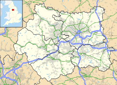
 Clifton
Clifton shown within West YorkshireOS grid reference SE159229 Metropolitan borough Calderdale Metropolitan county West Yorkshire Region Yorkshire and the Humber Country England Sovereign state United Kingdom Post town BRIGHOUSE Postcode district HD6 Dialling code 01484 Police West Yorkshire Fire West Yorkshire Ambulance Yorkshire EU Parliament Yorkshire and the Humber UK Parliament Calder Valley List of places: UK • England • Yorkshire Clifton is a small village, near Brighouse, in the Metropolitan borough of Calderdale in West Yorkshire, England.
Contents
History
Clifton is mentioned as Cliftone in the Domesday book of 1086.
Governance
Clifton Civil Parish merged with the neighbouring Borough of Brighouse in 1937. The borough was abolished in 1974 when it became part the metropolitan borough of Calderdale within the Metropolitan county of West Yorkshire.
Geography
The village is situated on the north side of the valley of the River Calder and the plateau adjoining it.
Nearby towns and villages

Bailiff Bridge Hartshead Moor Brighouse 
Hartshead  Clifton

Rastrick River Calder M62 Motorway Culture and community
There are two public houses situated at either end of the main street (Towngate); one, the Black Horse Inn, was the Yorkshire Post pub restaurant of the year 2006. Clifton also has a small hairdressing salon.
Clifton also gives its name to the Clifton & Lightcliffe brass band. This is one of the countries oldest being formed in 1838.[citation needed] The band HQ is in nearby Bailiff Bridge.
Landmarks
There are many local historical references connected to drift mining. It was first recorded in 1307 and also mentioned by Daniel Defoe, author of Robinson Crusoe, in his 1727 book 'A Tour Of Great Brittain'. On the western flank of the village is a long straight ridge, which constitutes the remains of a gravity railway that was last used to transport coal in 1920 to the (then) municipal gasworks by the Calder and Hebble Navigation at Brighouse. There are also intriguing historical connections such as America Lane, the fever hospital and Clifton 'airport' used by Sir Alan Cobham's Air Circus between the two world wars. The remains of the village well can be seen opposite the school. At the easterly edge of the village is the 16C Kirklees Hall, whose grounds contain the reputed grave of Robin Hood. The Hall was the model for 'Nunwood' in Charlotte Bronte's novel 'Shirley'. At the northerly end of the village, there remains evidence of strip farming, also known as 'open field system'. Originally there were thirty-two strips of land and families would work two or three of these. Beyond were fields known as the Doles; these were common grazing land. Doles Lane, a public right of way, still exists and starts (as Well Lane), opposite the Black Horse Inn. This inn was a meeting place for Luddites, the machine wreckers, in the early 19th century. Highley Hall (formerly Crosse Hall), near the war memorial, was a farm until the 1990s. Originally the family home of Richard de Hileagh, constable of the village in the mid 14th century; it is once again a private residence.
Education
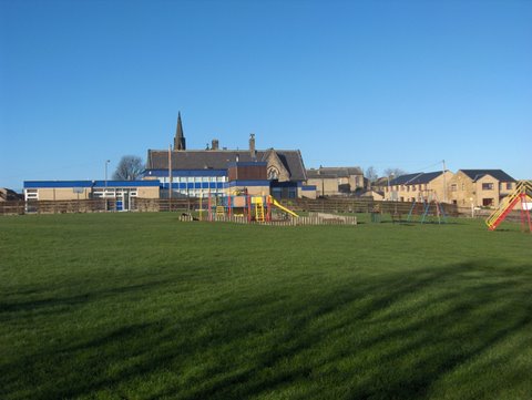
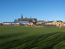 Clifton School viewed across the recreation ground.
Clifton village, a 'Village Design Statement' area, has a Junior and Infant school built in the 1870s (a consistent top performing school - 'outstanding' in successive Ofsted inspections - April 2008 and seventh best in England for SATS level 5 - December 2007).
Religious sites
There is an Anglican church (first baptism Goldthorpe Squire 1859, first burial Zillah Ramsden 1860) within the Diocese of Wakefield, and a Methodist church. Patrick Brontë, father of the novelist sisters, was Minister at the nearby Hartshead-cum-Clifton church.
Sport
Adjacent to the village is Willow Valley Golf Club. Each June, the club hosts the annual Yorkshire PGA Championship.
External links
Categories:- Villages in West Yorkshire
- Geography of Calderdale

Wikimedia Foundation. 2010.