- City of Palmerston
-
This article is about a local government area and authority. For the city, see Palmerston, Northern Territory.
City of Palmerston
Northern Territory
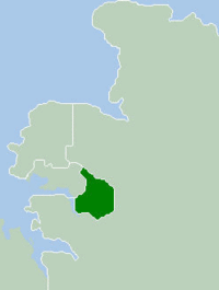
Location within Darwin metropolitan areaPopulation: 29,346(2009)[1] Established: 1981 Area: 95.6 km² (36.9 sq mi) Mayor: Robert Macleod JP Council Seat: Palmerston City Region: Outer Darwin Federal Division: Solomon 
LGAs around City of Palmerston: Darwin Litchfield Cox Peninsula City of Palmerston Litchfield Litchfield Litchfield Litchfield The City of Palmerston is a Local Government Area of the Northern Territory. It contains the suburbs of Darwin's satellite city, Palmerston, and is situated between the outer industrial areas of Darwin and the rural areas of Howard Springs. The City covers an area of 56.3 km² and has a population of about 25,000.
The Palmerston City Council consists of the Mayor and six aldermen. The city is not divided into wards, thus each alderman represents constituents from the entire city. Council elections are held on the last Saturday in May on leap years.
Contents
History
The City of Palmerston was incorporated in 1981 under the Local Government Act (NT), and in 2000 was proclaimed the Northern Territory's second city.
Suburbs
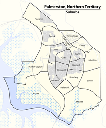
Suburbs of the inner city and of the outskirts, with post codes in parenthesis:
Suburbs Map Inner City Outskirts - Archer (0830)
- Johnston (0830)
- Marlow Lagoon (0830)
- Mitchell (0832)
- Pinelands (0829)
- Zuccoli (0830)
Sister cities
References
- ^ Australian Bureau of Statistics (30 March 2010). "Regional Population Growth, Australia, 2008–09". http://www.abs.gov.au/ausstats/abs@.nsf/Latestproducts/3218.0Main%20Features102008-09?opendocument&tabname=Summary&prodno=3218.0&issue=2008-09&num=&view=. Retrieved 4 June 2010.
External links
Suburbs of the City of Palmerston | Darwin | Northern Territory Inner City: Outskirts: Local Government Areas of the Northern Territory Darwin Region Belyuen · Coomalie · Darwin · Darwin Rates Act Area · Litchfield · Palmerston · Tiwi Islands · Unincorporated Top End Region · WagaitKatherine Region Katherine · Victoria Daly · Roper GulfArnhem Land Barkly Tableland Central Australia Coordinates: 12°29′38″S 130°58′54″E / 12.4939°S 130.9818°E
Categories:- Populated places established in 1981
- 1981 establishments in Australia
- Local Government Areas of the Northern Territory
- Darwin, Northern Territory
Wikimedia Foundation. 2010.


