- Nandlstadt
-
Nandlstadt 

 NandlstadtLocation of Nandlstadt within Freising district
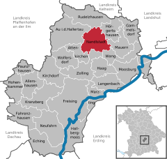
Coordinates 48°32′N 11°48′E / 48.53333°N 11.8°ECoordinates: 48°32′N 11°48′E / 48.53333°N 11.8°E Administration Country Germany State Bavaria Admin. region Upper Bavaria District Freising Mayor Jakob Hartl (CSU) Basic statistics Area 34.31 km2 (13.25 sq mi) Elevation 465 m (1526 ft) Population 4,977 (31 December 2010)[1] - Density 145 /km2 (376 /sq mi) Other information Time zone CET/CEST (UTC+1/+2) Licence plate FS Postal code 85405 Area code 08756 Website www.markt-nandlstadt.de Nandlstadt is a municipality in the district of Freising in Bavaria in Germany. Nandlstadt is said to be the oldest hop-growing area in the world, having grown them since the year 860. The town lies in a triangle between Freising, Moosburg and Mainburg.
Allershausen | Attenkirchen | Au in der Hallertau | Eching | Fahrenzhausen | Freising | Gammelsdorf | Haag an der Amper | Hallbergmoos | Hohenkammer | Hörgertshausen | Kirchdorf an der Amper | Kranzberg | Langenbach | Marzling | Mauern | Moosburg | Nandlstadt | Neufahrn bei Freising | Paunzhausen | Rudelzhausen | Wang | Wolfersdorf | Zolling
References
- ^ "Fortschreibung des Bevölkerungsstandes" (in German). Bayerisches Landesamt für Statistik und Datenverarbeitung. 31 December 2010. https://www.statistikdaten.bayern.de/genesis/online?language=de&sequenz=tabelleErgebnis&selectionname=12411-009r&sachmerkmal=QUASTI&sachschluessel=SQUART04&startjahr=2010&endjahr=2010.
Categories:- Municipalities in Bavaria
- Freising district
- Upper Bavaria geography stubs


Wikimedia Foundation. 2010.